Blog Article
July 30, 2026 Tornado Recap: Nebraska and Illinois Twisters
Full recap of July 30, 2026 severe weather: a confirmed EF-1 tornado near Chicago, a Nebraska landspout, and Florida Panhandle wind damage, plus what's next.
July 30, 2026 Severe Weather Recap: Two Tornadoes, One in Nebraska, One Nobody Saw Coming Near Chicago
Alright folks, here's the thing about July 30. The tornado everybody was watching for showed up right where SPC said it might, out in the Nebraska Sandhills. But the tornado that actually did damage snuck in overnight near Chicago, in an area that wasn't even in the risk area the day before. That's the story of yesterday in a nutshell: the Plains forecast held up, and the Midwest handed us a surprise.
How the Day Unfolded
The first tornado of the day actually happened before most folks in the Central time zone were even awake. Around 1 AM local time, a tornado touched down 2 miles east of Glenwood, Illinois. A member of the public reported it, and NWS Chicago's storm survey confirmed it as an EF-1 with peak winds of 110 mph, a path width of 225 yards, and a track of 3.7 miles through the Lansing and Munster area. That's a real tornado with real damage potential, and it happened well outside the Slight and Marginal risk areas SPC had drawn for the Plains and Southeast.
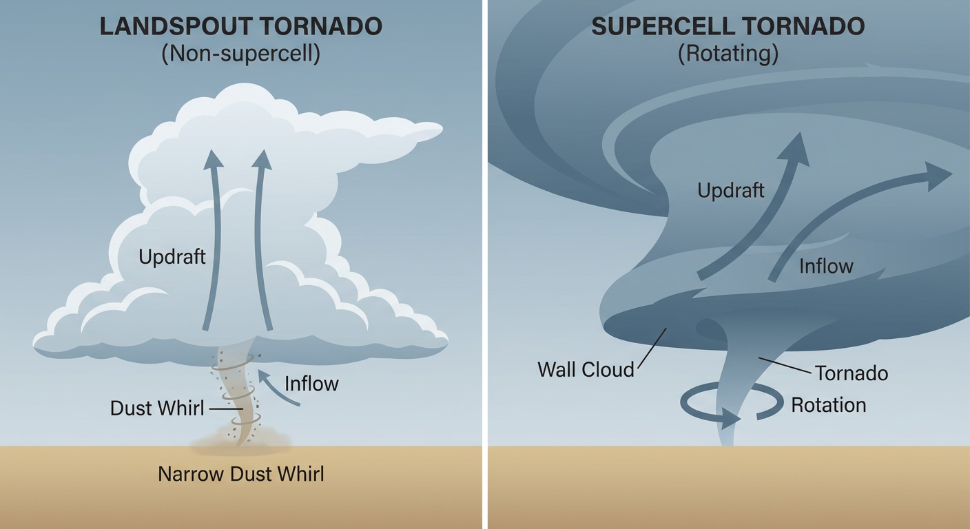
The rest of the day tracked much closer to script. SPC's Slight Risk was centered on towns like Ainsworth, Albion, and Aurora, Nebraska, and sure enough, a Mesoscale Convective System organized over the central Plains through the afternoon. A CO-OP observer reported a brief landspout tornado 20 miles north of Mullen, Nebraska, around 4:33 PM local time. Landspouts are weaker, shorter-lived spinups than the supercell tornadoes you'd get from a classic hook echo, but they're still tornadoes, and this one got logged as a confirmed report.
By late afternoon, wind damage started showing up on the northern edge of that MCS too. Grand Forks, North Dakota picked up a downed tree at a golf course on the south side of town, reported by broadcast media and confirmed by radar timing.
Then, as the sun dropped in the Southeast, the Florida Panhandle lit up almost exactly like it had the day before. Between about 5:20 and 5:45 PM Eastern, Tallahassee's local NWS office fielded a string of tree and power line reports: a tree down at Kemp Road and Iron Bridge Road in Havana, a smoking limb on power lines at Mission San Luis, a downed tree and power line in Shadeville, and a transformer fire in Panacea after a tree took out a line on Chipola Road. None of it rose to tornado level, but it was enough to cut power to pockets of the capital region.
Confirmed Facts From Yesterday
- Tornado, Lansing/Munster, IL area: NWS survey confirmed EF-1, 110 mph peak winds, 225-yard width, 3.7-mile path. Reported near 2 E Glenwood, IL.
- Tornado, near Mullen, NE: Brief landspout reported by a CO-OP observer, 20 miles north of Mullen.
- Wind damage, Florida Panhandle: Multiple 911 and emergency management reports of trees and power lines down across Havana, Mission San Luis, Shadeville, Panacea, and Freemont, including one transformer fire.
- Wind damage, Grand Forks, ND: Tree down at a local golf course, confirmed via radar-timed broadcast media report.
- Space weather: An S1 Minor solar radiation storm persisted through the back half of the day, a fairly rare mention for a severe weather recap but notable all the same.
Forecast vs. What Actually Happened
Give credit where it's due. SPC's Slight Risk over Nebraska and the northern Plains verified with an actual tornado report near Mullen, and the MCS that rolled through did exactly what the outlook said it would, organized wind and hail threat, isolated tornado potential included. The Florida Panhandle also verified close to the letter. Yesterday's blog specifically compared the day's expected Gulf Coast wind damage to the tree-and-powerline pattern from the day before, and that's exactly what showed up in Havana, Shadeville, and Panacea.
Where the forecast missed was Illinois. Nothing in the previous outlook mentioned tornado potential anywhere near Chicago, Lansing, or Munster. That EF-1 came out of an overnight setup that wasn't part of the Slight or Marginal risk discussion at all. It's a good reminder that SPC outlooks are probabilities, not guarantees, and that overnight, low-topped convection can still produce a real tornado outside the highlighted zones.
What's Coming Next
The pattern is shifting east and turning wetter. WPC has a Slight Risk for excessive rainfall posted today across the mid to upper Mississippi Valley, with precipitable water values still running at 2 inches or better, well above normal for late July. That flash flood threat is expected to nudge into the Ohio and Tennessee Valleys and the Great Lakes by Saturday and Sunday, covering cities like Nashville, Louisville, and Cincinnati.
Meanwhile, out west, a heat wave is building across the Southwest and Intermountain West, and WPC's extended discussion says that ridge holds strong into next week. Tropically, there's nothing to watch right now. Zero active storms and zero disturbances in either ocean basin as of this morning. Space weather is expected to stay quiet to unsettled with just a chance of M-class flares through August 2, nothing that should affect daily life.
Bottom Line
July 30 confirmed two separate tornadoes, a brief landspout in the Nebraska Sandhills that fell right where the forecast said storms might spin up, and a surveyed EF-1 near Chicago that came out of nowhere on the outlook maps. The Plains and Florida Panhandle threats verified about as well as a forecast can. The lesson from Illinois is the one worth remembering: a Marginal or even unmentioned area can still produce a real tornado overnight, especially with a strong shortwave and enough low-level shear in place. Keep your weather radio on even on the nights the outlook looks quiet.