Blog Article
August 03, 2026 Weather Recap: Keys Waterspouts & Flooding
A fact-checked recap of August 03, 2026: waterspouts off the Florida Keys, I-95 corridor flooding, and wind damage from North Dakota to North Carolina.

August 03, 2026 Severe Weather Recap: Waterspouts Off the Keys, Flooding Along I-95
Alright folks, let's talk about yesterday. The one tornado-family event on the books for August 3 wasn't a supercell chewing through farmland. It was a string of waterspouts twisting up off the Florida Keys, confirmed by an off-duty NWS meteorologist, a NAS Key West weather observer, and folks with their phones out on the Channel 5 Bridge.
The Headline Moment: Waterspouts Off Long Key and Key West
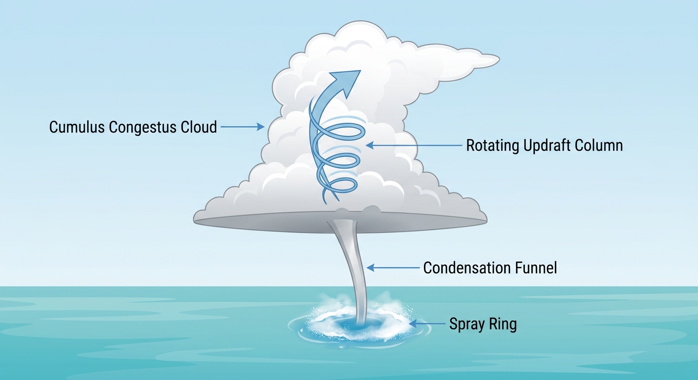
Around 3:30 PM local time near 3 NW Layton, FL, a mature, nearly vertical waterspout formed bayside of Long Key. Video from the Channel 5 Bridge showed a full condensation funnel reaching from cloud base to the water, spray ring and all. It drifted slowly east-northeast and lasted about 10 minutes.
That was just the opener. A few hours later, southeast of Key West and Stock Island, observers counted three separate waterspouts at once. An off-duty NWS meteorologist and the NAS Key West weather observer both had eyes on them. One was mostly vertical, one sat at a 45 degree lean, and the widest of the three kicked out to about a 60 degree angle partway up. All three had full condensation clouds and visible spray rings, and they were still going strong more than 30 minutes after first being spotted.
To be clear on what this was and wasn't: these were waterspouts over open water near the Keys, not tornadoes tearing through a neighborhood. No damage was reported from them, and there's no NWS survey or rating attached to any of these reports. If you see anyone claiming an EF-rating out of the Keys yesterday, that's not something the data backs up.
How the Day Actually Unfolded
- Overnight into early morning: The flash flood engine that had been working over the Mid-Atlantic and Northeast kept grinding. A tree came down with wires on US 9 near Cold Spring, NY around 4 AM local, closing both lanes. Rainfall totals topping 4 inches were reported in multiple spots across the Mid-Atlantic, building on the nearly 5 inches that fell in places like Maple Shade, NJ in the days before.
- Midday: SPC issued Severe Thunderstorm Watch 537 covering Minnesota and North Dakota. Wind damage showed up fast, with tree branches down around Bismarck, ND, timed right alongside the peak wind gust at the KBIS airport sensor.
- Afternoon: Monsoonal thunderstorms fired up across Arizona as expected for early August, part of the broader Southwest pattern that's been feeding wind and hail threats all week.
- Evening: A thunderstorm rolled through South Florida and tore metal roofing off a carport near Opa-Locka. Later that evening, a tree fell on a powerline near Silver City, NC, knocking out power through Duke Energy's system. That's the same corner of the Carolinas SPC had flagged.
- Late evening into overnight: The Keys waterspout show wrapped up the day, with the second batch of spouts confirmed ongoing past 7 PM local time.
What the Data Actually Confirmed
- Multiple waterspouts near Long Key and Key West, FL, all with full condensation funnels and visible spray rings, none causing reported damage
- Wind damage reports in Opa-Locka, FL (carport roofing failure), Cold Spring, NY (tree and wires down, road closed), Bismarck, ND (tree branches down), and Silver City, NC (tree on powerline, power outage)
- Rainfall exceeding 4 inches in parts of the Mid-Atlantic, continuing a multi-day flooding stretch along the I-95 corridor
- Severe Thunderstorm Watch 537 issued for Minnesota and North Dakota
Forecast Versus Reality
The previous day's outlook nailed the western Carolinas piece. SPC had a Marginal Risk up for Charlotte, Greenville, and Columbia, pointing to an isolated damaging wind threat, and sure enough, that's exactly where the Silver City tree-on-powerline report landed. Good forecast, good outcome.
What nobody flagged ahead of time was the Florida Keys. There was no severe weather outlook language pointing toward waterspouts off Long Key or Key West. That's not really a forecasting miss so much as the nature of the beast. Waterspouts over warm, humid, unstable Gulf and Atlantic waters in early August often develop with very little lead time, sometimes from garden-variety cumulus towers rather than organized severe storms. SPC outlooks are built around organized severe thunderstorm threats, not the kind of localized instability that spins up a Keys waterspout on a summer afternoon.
The Mid-Atlantic and Northeast flooding also played out about like advertised, a continuation of the training thunderstorm pattern that had already dumped heavy rain in New Jersey and Pennsylvania in the days prior. The Northern Plains wind damage in North Dakota lined up with an active severe thunderstorm watch, which is the system working the way it's supposed to.
What's Coming Next
The pattern is rotating again. Today, SPC has a Marginal Risk of severe thunderstorms split between the western Carolinas and the southern Rockies into southeast Arizona, mostly a wind and hail threat. WPC has a Slight Risk of excessive rainfall tucked into southern and southeastern Arizona too, so burn scars and steep terrain out there need to be watched closely.
By Wednesday, the severe threat baton passes north and west again, with SPC eyeing a corridor from Missouri into central Illinois and a separate zone from northeast New Mexico into the Texas and Oklahoma Panhandles. There's even a small 2 percent isolated tornado chance penciled in for that Missouri and Illinois zone, though wind and hail remain the headline threats there, not widespread tornado activity. Right behind that, WPC has a Slight Risk of excessive rainfall lined up for the Central Plains into the middle Mississippi Valley on Wednesday.
Meanwhile, out west, the ridge is not going anywhere. Confidence keeps building that the Southwest and eventually the Intermountain West settle into a stretch of above normal heat that holds through the weekend, with CPC now also flagging an enhanced risk for rapid drought onset across the Central to Southern Plains and Ozarks over the next couple weeks if the dry pattern holds.
Bottom Line
Yesterday's tornado-family event was a set of confirmed, harmless waterspouts off the Florida Keys, not a land tornado, and nothing in the data supports any damage rating attached to them. The bigger real-world impact came from the ongoing flash flooding along the I-95 corridor and scattered wind damage from North Dakota down to North Carolina. The forecast got the Carolinas wind threat right and the Northeast flooding pattern right. What it couldn't have flagged was a Keys waterspout outbreak, and that's a good reminder that not every rotating column of air shows up on a convective outlook. Keep an eye on the Southwest heat and flash flood risk and the Wednesday severe threat sliding into Missouri and Illinois, because that's where the next chapter is being written.