Blog Article
Historic March Heatwave, Fire Danger & Weekend Severe Weather
The Central US is facing record-breaking March heat and critical fire danger. Plus, track the weekend severe weather risk for the Ohio Valley and a G3 solar storm.

Record-Smashing March Heat, Critical Fire Danger, And... Northern Lights?
Alright folks, welcome back. Yesterday we talked about what a Tornadic Debris Signature (TDS) is and touched on the storm risk for the Ohio Valley. Today, the overall weather pattern is taking a massive swing. We are looking at a truly wild setup across the country as we head into the weekend.
Here is the thing. We are going from historic blizzards in the Upper Midwest just a few days ago to mind-boggling heat in the Central Plains. And if that is not enough, we have a solar storm heading our way that might put on a show in the night sky.
Let's break it all down.
The Heat is On (And So is the Fire Risk)
Get this. Temperatures in the Central U.S. are about to skyrocket 30 to 40 degrees above normal for this time of year. We are talking about locations in the Nebraska Panhandle potentially reaching the mid-90s on Saturday. That is not just warm for March. That is breaking all-time records for both March and April.
If you are heading out to MLB Spring Training games in Arizona today, like the Diamondbacks or Royals games, keep the sunscreen and water handy. Phoenix just set an all-time March record of 105 degrees yesterday, and that heat dome is now sliding east.
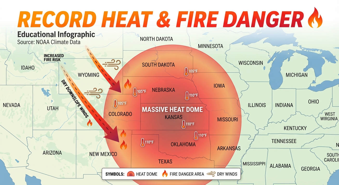
With this kind of unseasonable heat comes a very serious threat. The Storm Prediction Center has outlined a Critical Fire Weather Area for central and eastern Wyoming today, which expands into western Nebraska and northwestern Colorado by tomorrow.
We have high pressure sitting over the mountains pushing dry downslope winds onto the plains. When you combine 30 mph wind gusts with humidity levels dropping down to 10 percent, any spark can turn into a raging wildfire instantly. We just saw massive fire warnings and evacuations in Oklahoma and Arkansas earlier this week. Please do not do any outdoor burning if you are in these critical zones y'all.
Space Weather: Look Up Tonight
Now for something a little different. We are tracking a G3 (Strong) Geomagnetic Storm.
The Sun recently fired off a Coronal Mass Ejection, which is basically a massive burst of solar wind and magnetic energy. It is expected to make a direct impact with Earth. Do not worry, the Earth's magnetic field protects us on the ground. But what it does do is supercharge the Northern Lights.
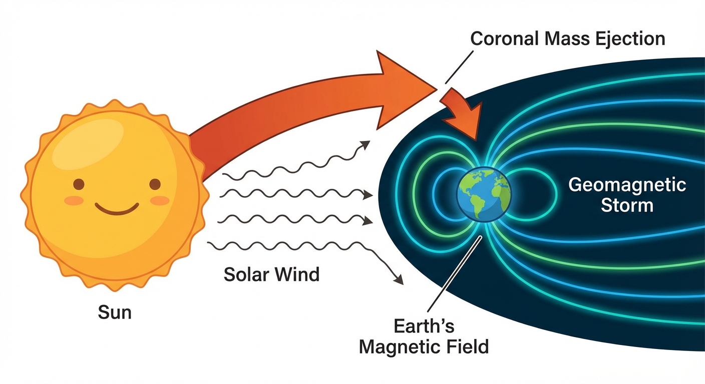
If the skies are clear where you are, especially across the northern tier of the U.S., you might just see the aurora borealis tonight or tomorrow night.
Sunday's Severe Weather Risk
While the Plains bake, we have to keep our eyes on the Ohio Valley. As we mentioned yesterday, there is a Marginal Risk for some strong storms in places like Pittsburgh and Canton today.
But Sunday is when things might get a bit more organized. The SPC has already issued a Slight Risk for severe thunderstorms on Sunday stretching across parts of the Ohio Valley. A mid-level shortwave is going to move in, dragging a cold front right into all that unseasonable warmth we just talked about.
Key areas to watch Sunday:
- Indianapolis, IN
- Columbus, OH
- Cincinnati, OH
- Louisville, KY
- Dayton, OH
As temperatures heat up on Sunday afternoon, the atmosphere is going to get unstable. We will be watching for damaging winds and large hail. If you are heading out to outdoor events on Sunday, make sure you have a way to get weather alerts.
The Pacific Northwest Keeps Taking on Water
Finally, I have to mention our friends out west. An atmospheric river, often called a Pineapple Express, is still funneling tropical moisture right into Washington state. We have a Marginal Risk of excessive rainfall for western Washington today and tomorrow. After seeing the Snohomish River hit moderate flood stage yesterday, the ground is completely saturated. Be incredibly careful driving around out there, as landslides and local flooding are still major hazards.
Bottom Line
- Central Plains: Prepare for historic, record-breaking heat into the 90s. Avoid any activities that could cause a spark in Wyoming, Nebraska, and Colorado due to critical fire danger.
- Ohio Valley: Keep the weather radio on standby for Sunday afternoon and evening. Strong to severe storms are possible.
- Pacific Northwest: Keep the umbrellas out and stay off flooded roadways.
- Night Owls: Look up! You might catch a rare glimpse of the Northern Lights thanks to that G3 solar storm.
Stay safe, stay weather aware, and I will talk to y'all soon!
https://ryanhallyall.com/blog/record-smashing-march-heat-critical-fire-danger-and-northern-lights