Blog Article
High Plains Severe Storms and Plains Flood Risk June 24
An Enhanced severe risk hits the Colorado and Wyoming High Plains while a Slight Risk of excessive rainfall threatens saturated Plains and Mid-South ground.
Same Pattern, New Day: The Plains Stay Wet While the High Plains Light Up Again
Alright y'all, here's the thing about this week. We keep waking up to the same setup. A big upper ridge parked over northern Mexico and the Southwest, a broad trough up north, and shortwaves rolling out of the Rockies every single afternoon like clockwork. That pattern has been the engine behind a brutal run of flash flooding and severe storms, and June 24 keeps the engine running.
Let's start with the story that worries me most: water.
The Flood Threat Is the Headline
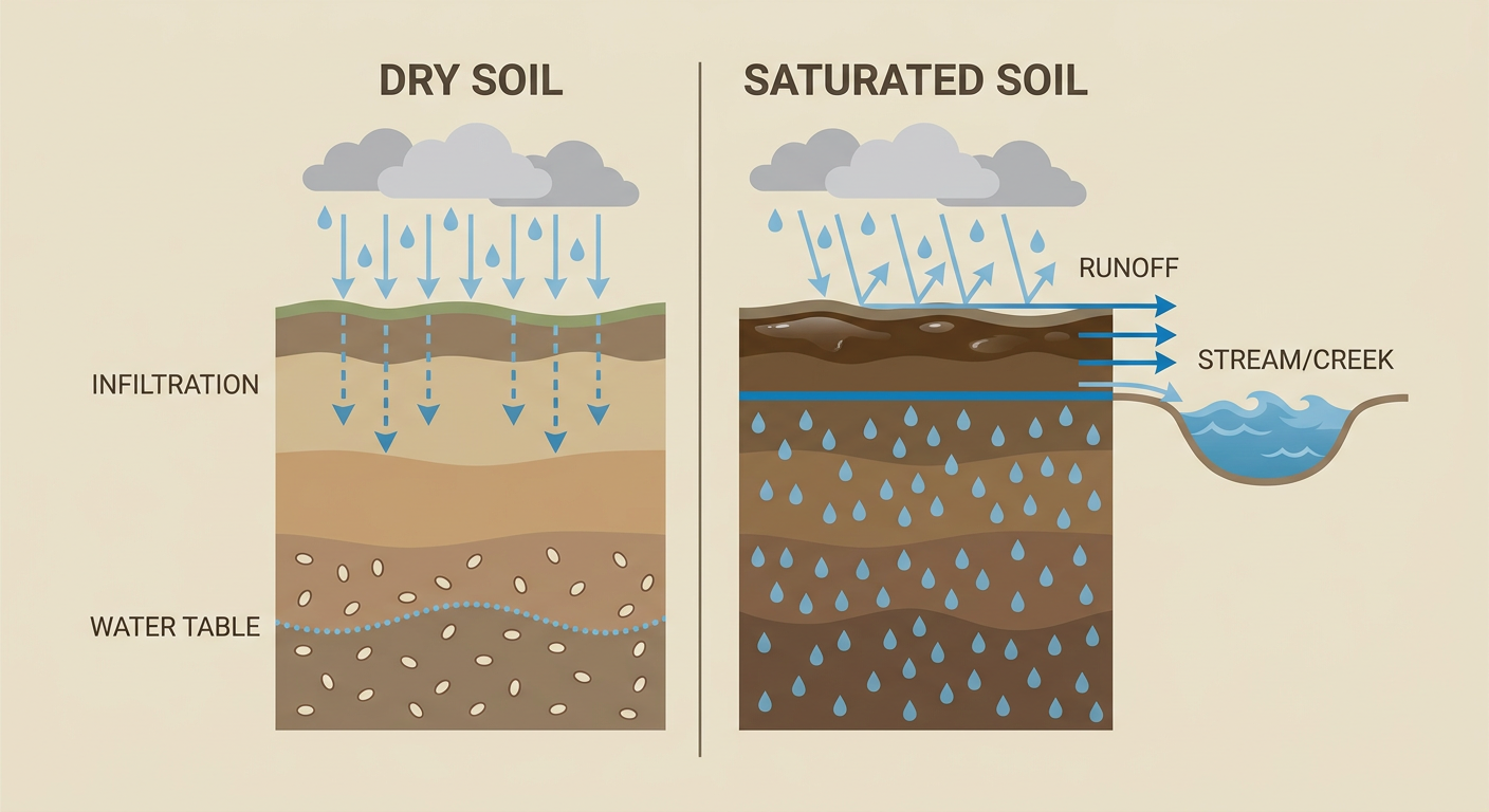
The Weather Prediction Center has a Slight Risk of excessive rainfall stretched from the central High Plains, through the Mid-South, down to the central Gulf Coast. A Slight Risk means at least a 15% chance of rainfall heavy enough to cause flash flooding within about 25 miles of you. On a normal week, that's a manageable day. This is not a normal week.
Get this. Just yesterday, Atoka County, Oklahoma got a Particularly Dangerous Situation Flash Flood Emergency after 4 to 8 inches of rain. Lamar County, Texas had boat rescues at an RV park. Southern West Virginia had washed-out bridges and active water rescues. The ground across a big chunk of the Plains and Mid-South is already soaked. When dirt can't soak up any more, new rain runs straight off into creeks and low spots. That's how you get fast-rising water on a setup that wouldn't normally scare anybody.
The heavy rain axis doesn't pack up and leave, either. WPC keeps a Slight Risk going Thursday across the central and southern Plains into the mid-Mississippi Valley, then shifts it east into the mid-Mississippi and Ohio Valleys on Friday. So if you're in that corridor, this is a multi-day watch, not a one-and-done.
The High Plains Get Lit Up Again
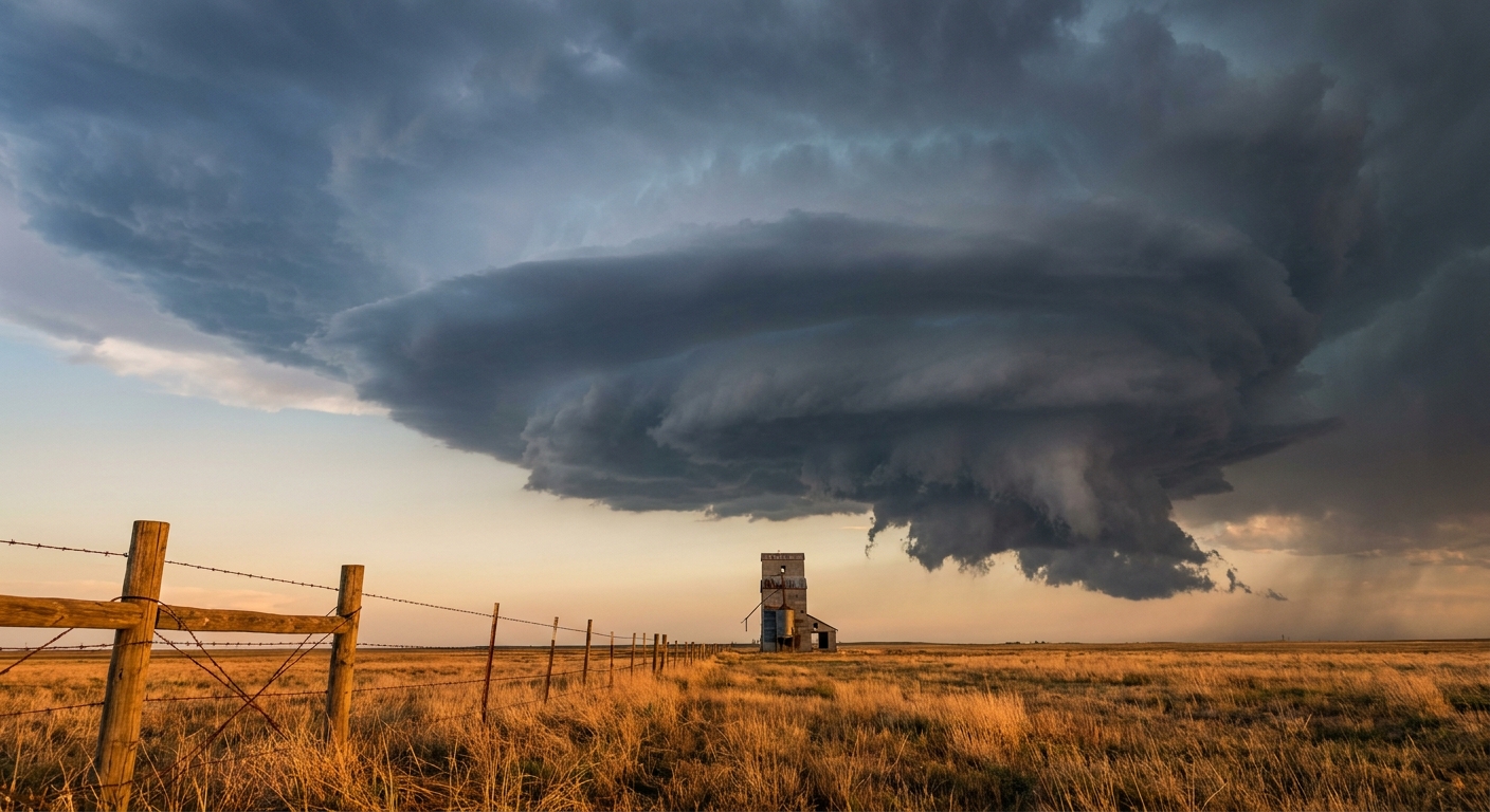
We talked yesterday about Denver and the Front Range sitting under an Enhanced Risk. Well, the High Plains aren't done. The Storm Prediction Center has another Enhanced Risk, that's Level 3 of 5, painted across the central High Plains today. This time the bullseye sits over northeast Colorado and southeast Wyoming, including Cheyenne, Akron, Fort Morgan, Sterling, and Yuma.
A wider Slight Risk wraps around that, and it pulls in Denver, Colorado Springs, Amarillo, and even Salt Lake City and Provo out in northern Utah. Here's what the data says you're dealing with inside the worst of it:
- Hail: A Level 2 (15%) scattered severe hail threat, with a hatched zone where stones could reach 3.5 inches. That's softball size. Big enough to total a windshield.
- Wind: A Level 2 (15%) scattered damaging wind threat, with a hatched area where gusts could hit 75 mph or more.
- Tornadoes: A Level 2 (5%) threat over the High Plains, meaning a few tornadoes are possible if storms get rooted.
The ingredients are there. Strong instability, plenty of wind shear, and a shortwave to kick storms off the high terrain in the afternoon. Three years ago to the day, Colorado produced a June EF3 tornado, and the setup today again supports significant severe weather on those plains. Not a guarantee, but a reason to keep your phone loud this afternoon.
There's also a more isolated severe threat scattered across the Upper Midwest, the Ozarks, and down toward Mississippi, plus that northern Utah piece. A Marginal Risk reaches all the way to Chicago, Oklahoma City, Memphis, Milwaukee, and Tulsa, so a stray strong storm is on the table for a lot of folks.
Don't Forget the Fire Side
Weird as it sounds on a day this wet elsewhere, SPC has a Critical Fire Weather area up for western and central Utah. The same shortwave that fires storms on the Plains kicks up high-based, dry thunderstorms out west. Those storms drop lightning on near-record dry fuels without much rain to go with it. Salt Lake City is in a strange spot: a fire weather concern and a severe wind concern in the same day.
What About the Ballgames and Festivals?
This matters for a few things on the calendar.
- Red Sox at Rockies, Coors Field, first pitch 1:10 local-ish in the data window. Denver is in the Slight Risk again. Afternoon and evening storms could bring delays, so keep an eye on the radar if you've got tickets.
- Dodgers at Twins and Diamondbacks at Cardinals. Minneapolis and St. Louis are both near that Marginal severe area. Probably playable, but a pop-up storm could interrupt.
- Summerfest Weekend 2 and Electric Forest both kick off Thursday in Milwaukee and Rothbury, Michigan. Milwaukee sits in the broad Marginal zone Wednesday, and storms linger in the Midwest through the week. Pack a poncho.
- The Cubs-Mets games in Queens and the slate across the Northeast look clean. The Ohio Valley and Mid-Atlantic actually get the nicest day in the country today behind a departing front. Low humidity, comfortable air. Enjoy it.
Temperature-wise, nothing wild. Denver should run near its June normal of 83 for a high. The Plains stay seasonably warm and humid, which is exactly the kind of moist air these storms feed on.
What I'm Watching
- Saturated ground in the Plains and Mid-South. This is the big one. New rain on soaked soil is the difference between a nuisance shower and a water rescue.
- Where the High Plains storms organize this afternoon. If they go up over northeast Colorado and southeast Wyoming and stay discrete, that's your large hail and isolated tornado window.
- Training storms in the central Plains Thursday and Friday. The AI guidance even flags a possible Moderate Risk upgrade for rainfall over Kansas and Missouri. We'll watch the WPC updates closely.
- Dry lightning in Utah. Lightning on dry fuels is how new fires start.
Bottom Line
If you're in the central High Plains today, especially northeast Colorado and southeast Wyoming, have a way to get warnings this afternoon and be ready to move indoors fast. Softball-size hail and 75 mph gusts are nothing to test. If you're anywhere from the Plains through the Mid-South where the ground is already soaked, the bigger danger is water. Never drive into a flooded road. You can't tell how deep it is or whether the road's even still under there. Folks in Utah, watch for new fire starts from dry lightning. And if you're lucky enough to be in the Ohio Valley or Mid-Atlantic, go outside and enjoy the best air the country's got today.