Blog Article
Plains Wind Threat and Midwest Flood Risk: July 8 Forecast
A Slight Risk for severe wind hits Nebraska while flash flooding threatens the Upper Midwest. Here's the July 8, 2026 weather setup and what to watch.

Same Story, New Corner: Flash Flood Risk Slides South While the Plains Line Up Another Wind Threat
Alright y'all, if this week feels like a loop, that's because the atmosphere keeps running the same play. Yesterday brought a confirmed tornado in Minnesota, 74 mph winds in South Dakota, and flash flooding that trapped vehicles from Virginia down through Kentucky and into the Raleigh metro. Get this: the Raleigh area logged report after report of trees on power lines and cars stranded in high water into the early morning hours today.
The pattern behind all of it is still parked over us. So let's talk about where the trouble goes next.
The Rain Threat Isn't Done
The Weather Prediction Center has a Slight Risk (at least 15%) for excessive rainfall today, running from the Central Plains up through the Upper Great Lakes. That's the headline threat, and here's why it matters more than the number suggests.
The ground across parts of the Midwest and Upper Mississippi Valley is already loaded. When soil is saturated, it can't soak up much more. So even a garden-variety downpour runs straight off into creeks and storm drains. The WPC discussion flags an overnight complex of storms that may still be rolling through parts of the region at the start of the day.
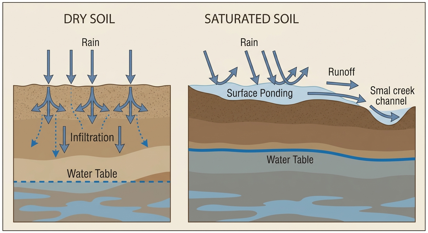
The risk continues into Thursday and Friday. WPC keeps a Slight Risk going Thursday over the Upper Mississippi Valley and Upper Great Lakes, then shifts it Friday into the Middle Mississippi, Ohio, and Tennessee Valleys plus the Central Appalachians. If you're in Minnesota or Wisconsin, that's your window to keep an eye on. The AI guidance points to areal averages of 1 to 2 inches with localized swaths over 3 inches, and precipitable water values running above the 90th percentile. Translation: the air is holding an unusual amount of water for storms to squeeze out.
The Severe Side: Nebraska, Watch Your Evening
SPC has a Slight Risk for severe storms today from the Central Plains into the Mid Missouri and Upper Mississippi Valleys. Omaha, Des Moines, Madison, and Green Bay all fall inside it.
The piece worth zeroing in on is southern Nebraska. SPC bumped the damaging wind probability there to 30%, which is the highest severe threat anywhere in the country today. The main hazard is wind. If storms organize this afternoon and evening, we're talking 60-plus mph gusts capable of knocking down trees and cutting power. That's a familiar tune for the Plains this month. We've already seen a 105 mph gust in Huron, South Dakota back on the 2nd, and 70-plus mph readings around Aberdeen just last night.
Here's the rundown of what SPC has posted for today:
- Wind: Up to 30% (Level 3, numerous damaging gusts) in southern Nebraska; broader 5 to 15% across the Plains and Upper Midwest
- Hail: 5% (Level 1, isolated) with quarter-size stones possible
- Tornado: 2% (Level 1, isolated) where the strongest storms fire
There's also a Marginal Risk for isolated severe gusts from North Carolina into southern Virginia. After the rough night the Raleigh-Durham area had, that's not the news anybody there wants, but it's a lower-end threat than what's setting up in the Plains.
Baseball Under the Gun
A whole slate of games sits inside or near today's risk zones. The Guardians visit the Twins in Minneapolis and the Brewers play the Cardinals in St. Louis, both in the general zone where afternoon and evening storms could bubble up. Up in Chicago, the Red Sox and White Sox play under a Marginal severe risk. If you've got tickets, keep an eye on the sky and expect the possibility of a rain delay.
The MLB All-Star Game is set for Philadelphia on July 14, and the All-Star festivities lead into it. Philly sits under a Marginal severe risk on the SPC Day 2 outlook for Thursday, so the wet, stormy pattern in the Northeast we talked about with the World Cup Final isn't going anywhere yet.
Heat and Fire Out West
While the eastern two-thirds of the country deals with storms and rain, the Southwest is still baking. The AI guidance notes heat indices of 105 to 115 across the Southeast and continued Excessive Heat Warnings in the Southwest. Fire weather stays elevated across the southern Great Basin, the Four Corners, and interior southern California, where relative humidity drops into the 5 to 15% range and holdover fires from recent lightning are a concern.
Where the Nice Weather Is
If you want the good stuff, look north and west. The Pacific Northwest and northern High Plains are the sweet spot the next few days, with light winds, comfortable dewpoints, and near-zero rain chances. That's the edge of a strong ridge building over the Northern Plains, and it's going to expand its grip over the weekend into early next week. Under that ridge, the central and southern parts of the country stay hot and humid.
One Quiet Note Overhead
Space weather stays mostly calm. SWPC expects quiet geomagnetic conditions through today, with a chance of unsettled to active levels on the 9th and 10th as a coronal-hole high-speed stream arrives. There's only a slight chance for an isolated period of G1 (Minor) storming, so this is more of a heads-up for aurora watchers in the far north than anything with real impact.
Bottom Line
The pattern hasn't changed, it's just moved the pieces around. Here's what to actually do today:
- Southern Nebraska and the Central Plains: Have a way to get warnings this afternoon and evening. Damaging wind is the main play, so secure loose outdoor items and be ready for power flickers.
- Minnesota, Wisconsin, and the Upper Midwest: Watch for heavy rain on already-soggy ground. Never drive into water over a road. You can't tell how deep it is or whether the road is even still there.
- Raleigh, Durham, and southern Virginia: A lower-end storm threat lingers after last night's mess. Give flooded spots time to drain and avoid the roads that gave trouble overnight.
- Southwest: Keep hydrating, limit midday outdoor work, and respect any fire restrictions.
Same airmass, same water-heavy summer setup. The trouble spots keep sliding around the map, but the ingredients are the same ones we've been tracking all week.