Blog Article
South Texas Flash Flood Risk Sunday: 2 to 4 Inches of Rain
A Level 2 of 4 flash flood risk covers South Texas on Sunday, with 2 to 3 inches of rain and locally more. Here's the timing, who's hit and what to do tonight.
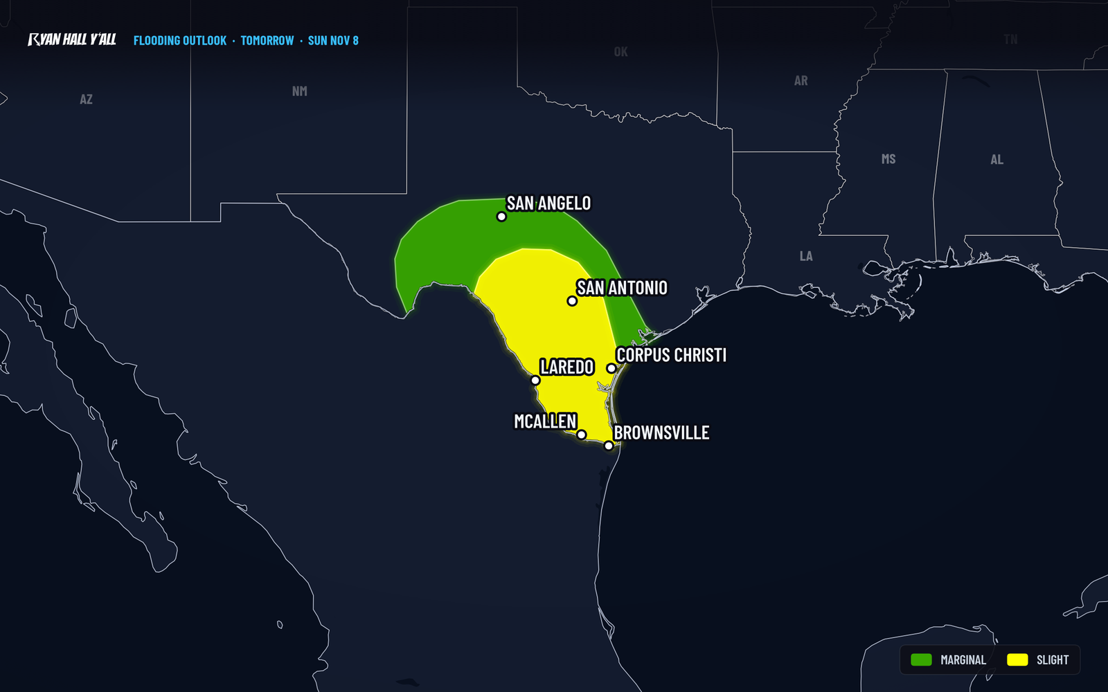
South Texas flash flood risk peaks Sunday with 2 to 3 inches, locally 4 to 6
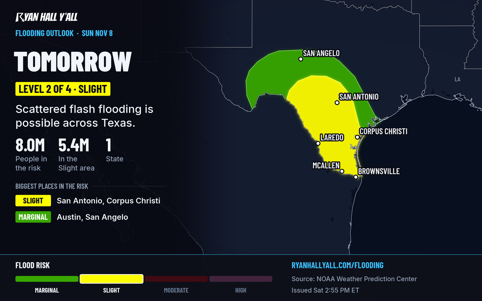
Heavy rain is building across South Texas tonight, and Sunday is the day that matters. A Level 2 of 4 (Slight Risk) for flash flooding covers the Hill Country, the Rio Grande Valley and the Coastal Bend from Sunday morning into Monday morning. Out West, a strong front brings gusts up to 60 mph to parts of the Oregon and south Washington coasts tonight.
The short version
- South Texas, Sunday into Monday morning: Rounds of heavy thunderstorms. Expect 2 to 3 inches in the core area, locally 4 to 6. Low-water crossings and creeks are among the main concerns.
- Tonight in Texas: Rain spreads across west, central and south Texas under a Level 1 of 4 risk. Most of it is manageable, but a few downpours could cause isolated trouble.
- South Washington and northern Oregon coasts, until 11 PM PST: Gusts up to 60 mph on the Clatsop, Tillamook and South Washington coasts. Isolated damaging gusts are possible near Forks late tonight.
- Washington Cascades, tonight into Sunday morning: Rain turns to snow around Washington Pass on SR-20. A few inches are possible.
- Hawaii: Tropical Storm Pena passes well to the south. No coastal watches or warnings are in effect.
South Texas has a Sunday flood threat
An upper-level storm is spinning into northern Mexico. Southeast winds are pumping Gulf moisture into Texas, and the air is carrying far more water than normal. That mix makes storms that rain hard and keep redeveloping over the same ground.
The most concerning swath runs from the Hill Country and Edwards Plateau down through Del Rio and Laredo toward Corpus Christi and the Coastal Bend. Brownsville and the lower Rio Grande Valley are in the wider rain shield. Rain should be ongoing Sunday morning, then get heavier and more widespread through the day.
Most places in the core area should see 2 to 3 inches. Persistent bands could drop 4 to 6 inches. Some computer guidance shows more than 8 inches near and east of Laredo, but that is a low-confidence outlier. The Slight Risk area is solid. Exactly where the heaviest bands set up is not.
One thing works in people's favor. Soils are dry, so the first round of rain soaks in. Flooding becomes more likely later Sunday, once the ground can't take more. Another 1 to 2 inches is possible Monday morning before the rain fades from west to east. Monday still carries a Level 1 of 4 risk.
What to do:
- Don't drive into water over the road.
- Avoid low-water crossings and dry creek beds after dark Sunday.
- Turn on Y'all Alerts and watch the flash flood outlook for changes.
Gusty front hits the Northwest coast tonight
A High Wind Warning runs until 11 PM PST for the Clatsop and Tillamook County coasts in Oregon and the South Washington coast. South winds of 20 to 30 mph will gust to 60 mph. Secure loose outdoor items and expect delays along coastal highways.
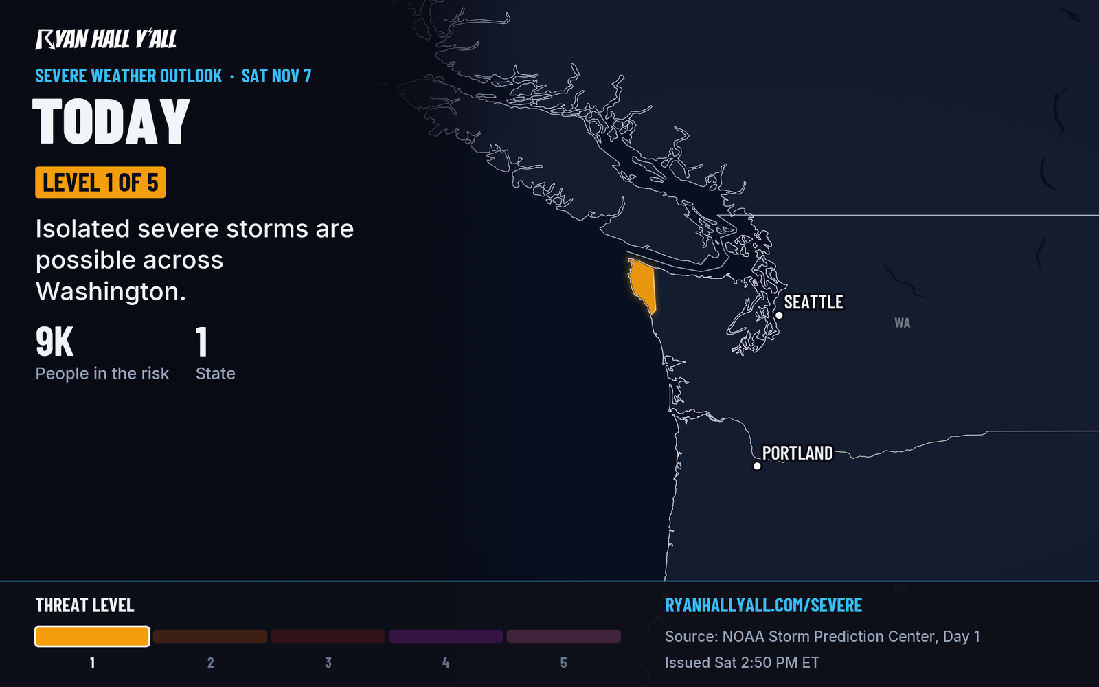
The front also puts a Level 1 of 5 (Marginal) severe risk on the northwest Washington coast near Forks. Isolated damaging gusts are possible late this evening into tonight, and the risk is small and narrow.
In the Cascades, snow levels drop from above 7,000 feet today to around 4,000 to 5,000 feet by Sunday morning. Washington Pass should change from rain to snow tonight. The odds of at least 4 inches are about 40 to 60 percent, and about 30 percent for 6 inches or more. Drive with caution if you're crossing SR-20. A lull Sunday night gives way to more Pacific moisture Monday. Light snow may reach Washington Pass Monday morning before changing to rain later in the day, with snow levels rising above pass level Monday night.
Pacific Coast surf stays dangerous through Monday
Beach hazard statements from San Francisco to Big Sur run through Monday evening. Breaking waves of 12 to 16 feet bring a risk of sneaker waves and strong rip currents. Keep off jetties and rocks. A coastal flood advisory for San Francisco and San Pablo bays runs through Friday. Advisories for the San Diego and Orange County coasts run through Tuesday, with minor to locally moderate flooding expected.
Pena stays south of Hawaii, and aurora chances are up
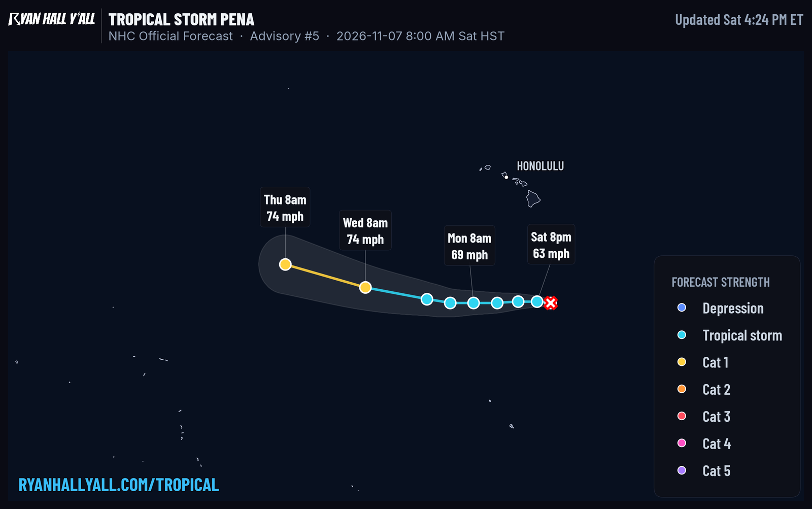
Tropical Storm Pena has top winds near 50 mph and is moving west-northwest at 9 mph. It's about 530 miles south-southeast of South Point on the Big Island. Its closest pass comes late Saturday night in Hawaii, and there are no hazards for land. Some strengthening is expected, but the track keeps it moving west, away from the islands.
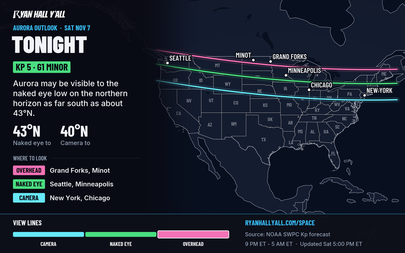
A fast stream of solar wind should push the geomagnetic field to G1 (Minor) storm levels tonight, with a chance of G2. Clear, dark skies in the northern U.S. are worth a look. Check our space weather page for updates.
Bottom line
South Texas should plan for a flash flood threat Sunday, with the heaviest rain expected from morning through Sunday night. Other hazards include wind and mountain snow in the Northwest and rough surf along the Pacific coast.