Blog Article
Weekend Forecast: South Texas Flood Rain Sunday, Nov 7-8
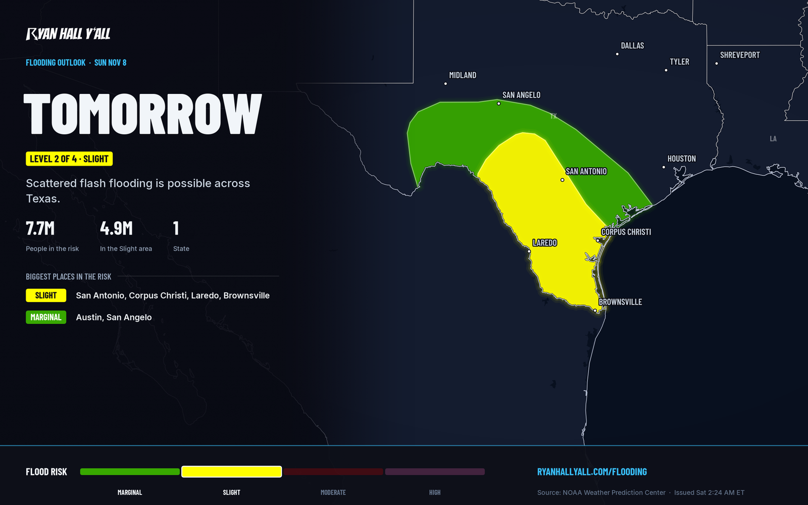
Level 2 of 4 flash flood risk for South Texas Sunday into Monday, with 2 to 4 inches of rain. Cool and dry elsewhere, plus where the weekend is great.
South Texas Flood Rain Sunday Leads a Mostly Cool, Calm Weekend Elsewhere
Heavy rain is the one weekend story that can wreck plans. It runs across South and south-central Texas from Sunday morning into early Monday, with a Level 2 of 4 (Slight) flash flood risk from the Hill Country down toward the Rio Grande Valley. Most of the country is dry and cool, and the Carolinas, the Panhandles and the Four Corners get the best of it.
The short version
- South Texas, Sunday into Monday morning: Widespread 2 to 3 inches, locally 4 to 6, from the Hill Country to the Rio Grande Valley. The core sits along and south of I-10.
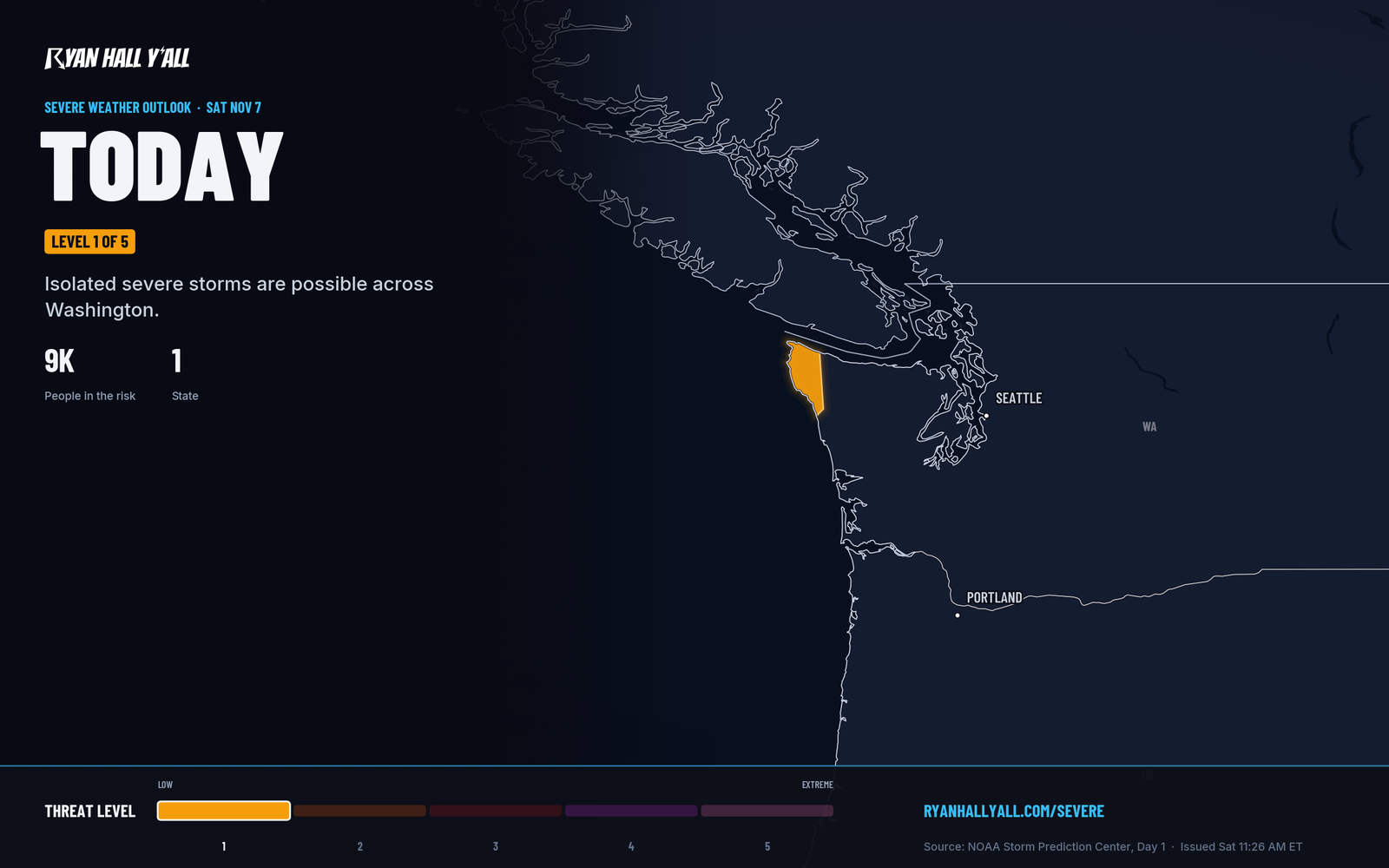
- Washington coast, tonight: A cold front brings isolated gusts of 60+ mph near Forks, a Level 1 of 5 (Marginal) severe risk. It is the only severe risk in the country this weekend.
- Cascades, tonight into Sunday: Rain turns to snow at Washington Pass, with snow levels falling to 4,000 to 5,000 feet by Sunday morning.
- Great Lakes and New England: Cold rain today and tonight, with some wet snowflakes mixing in over higher terrain.
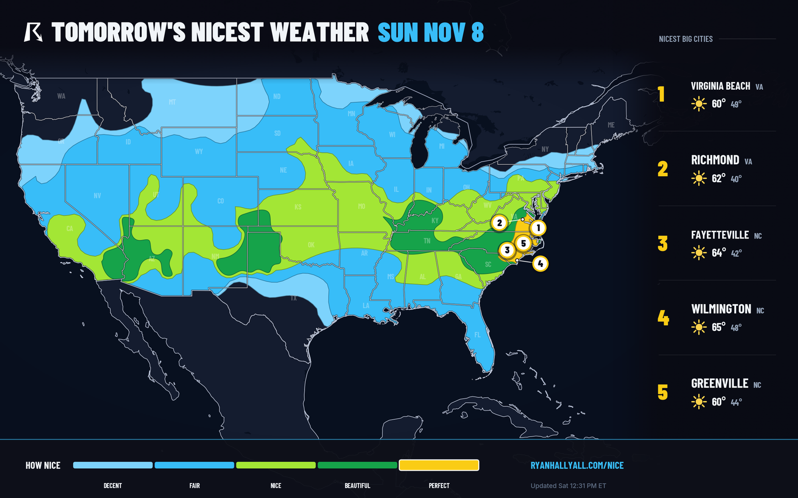
- Best weather: Eastern North Carolina and southeastern Virginia on Sunday, plus the Texas and Oklahoma Panhandles and the Four Corners today.
Friday night
Friday night is already behind us. The forecast for eastern North Carolina turns quiet and sunny.
Saturday
Texas: Rain is already falling from southern New Mexico into West Texas. Through tonight it shifts south and east, and the heavier rain builds over South Texas after dark. Saturday carries a Level 1 of 4 flood risk, so localized flooding is possible, but this is not the main event.
Pacific Northwest: A cold front reaches the northwest Washington coast late this evening, Pacific time. A band of rain along it could mix strong gusts to the ground, with 60+ mph possible near Forks. Gusts like that can drop limbs on power lines. Only about 9,000 people live in the risk zone, and the rest of the country has no severe risk. Behind the front, snow levels fall and Washington Pass (SR-20) goes from rain to snow tonight.
Elsewhere: A large area of high pressure keeps most of the country dry. Highs run around 60 across much of the Plains and Mid-Atlantic. A round of cold rain pushes from the lower Great Lakes into New England. Santa Ana winds blow in the hills around the San Gabriel Valley, with gusts of 30 to 40 mph and very dry air, so careful with any outdoor fire.
Sunday
South Texas: This is the day to plan around. Moisture from the Gulf streams in, and rain starts Sunday morning across the Edwards Plateau and Hill Country. The steadiest rain sinks south through the afternoon and evening toward Laredo, the Coastal Bend and Corpus Christi, and the lower Rio Grande Valley toward Brownsville. The rain hangs around for 24 hours or more, so the same spots can get hit again and again. That is how a few inches turns into flooded low-water crossings and creeks coming up fast.
What to do: don't drive into water over the road, especially Sunday night. Give yourself extra time on I-10 and I-35 from San Antonio toward Austin. Check the flash flood outlook before you head out. A lower-confidence scenario puts totals above 8 inches near and east of Laredo if storms keep repeating over one area. The exact placement of the heaviest rain can still shift.
Northern tier: Cold rain lingers in Maine until Sunday night. A clipper system then brings another round of rain to the lower Great Lakes and upstate New York early Monday. In the Pacific Northwest, Sunday night is a lull after the front, with another surge of moisture arriving Monday.
Sky watchers: The space weather outlook calls for likely G1 (Minor) geomagnetic storm levels, with a chance of G2 (Moderate) levels, through Sunday. Check our space page after dark.
Best bets
- Eastern North Carolina and southeastern Virginia, Sunday: This is the best weather in the country. Sunny skies, light wind, and highs near 62 with lows in the low 40s, from Richmond down through Fayetteville to Wilmington.
- Texas and Oklahoma Panhandles, southeastern Colorado and the Four Corners, Saturday: Almost no clouds and light wind, with highs around 60. It's a good day for a hike or yard work.
- Phoenix, the Tennessee Valley, Alabama and Georgia, Monday: If you need a day to catch up on outdoor chores, this is one. Our Nice Weather outlook has the city-by-city rankings.
Bottom line
South Texas needs a flood plan from Sunday morning through early Monday, while much of the rest of the country gets a cool, dry weekend. Tropical Storm Pena is far out in the Central Pacific and threatens no land.