Blog Article
Midwest Snow & Southern Plains Severe Weather Forecast | April 6
Track a sneaky midwest snow band, ongoing Florida rain, and a developing severe weather threat for the Southern Plains later this week.
Spring Whiplash: Sneaky Midwest Snow, Southern Sunshine, and Plains Storms
Alright y'all, we have a fascinating setup across the country today. As we talked about yesterday, that stalled front over Florida is still causing headaches. If you're heading down to the Tampa Bay Wine and Food Festival tomorrow, pack the rain gear. That Marginal Risk for excessive rainfall is holding steady through Wednesday.
But for a huge chunk of the country, today is an absolute stunner.
The Massive Spring High
A sprawling area of high pressure is dominating the Central and Southern U.S. right now. The air is incredibly dry, the skies are clear, and the humidity is non-existent. Down in Dallas, the average high for early April is 77 degrees. You're going to see numbers right around there with perfect sunshine today. If you have yard work to tackle or just want to eat dinner on the patio, this is your window.
Winter's Last Gasp in the Midwest
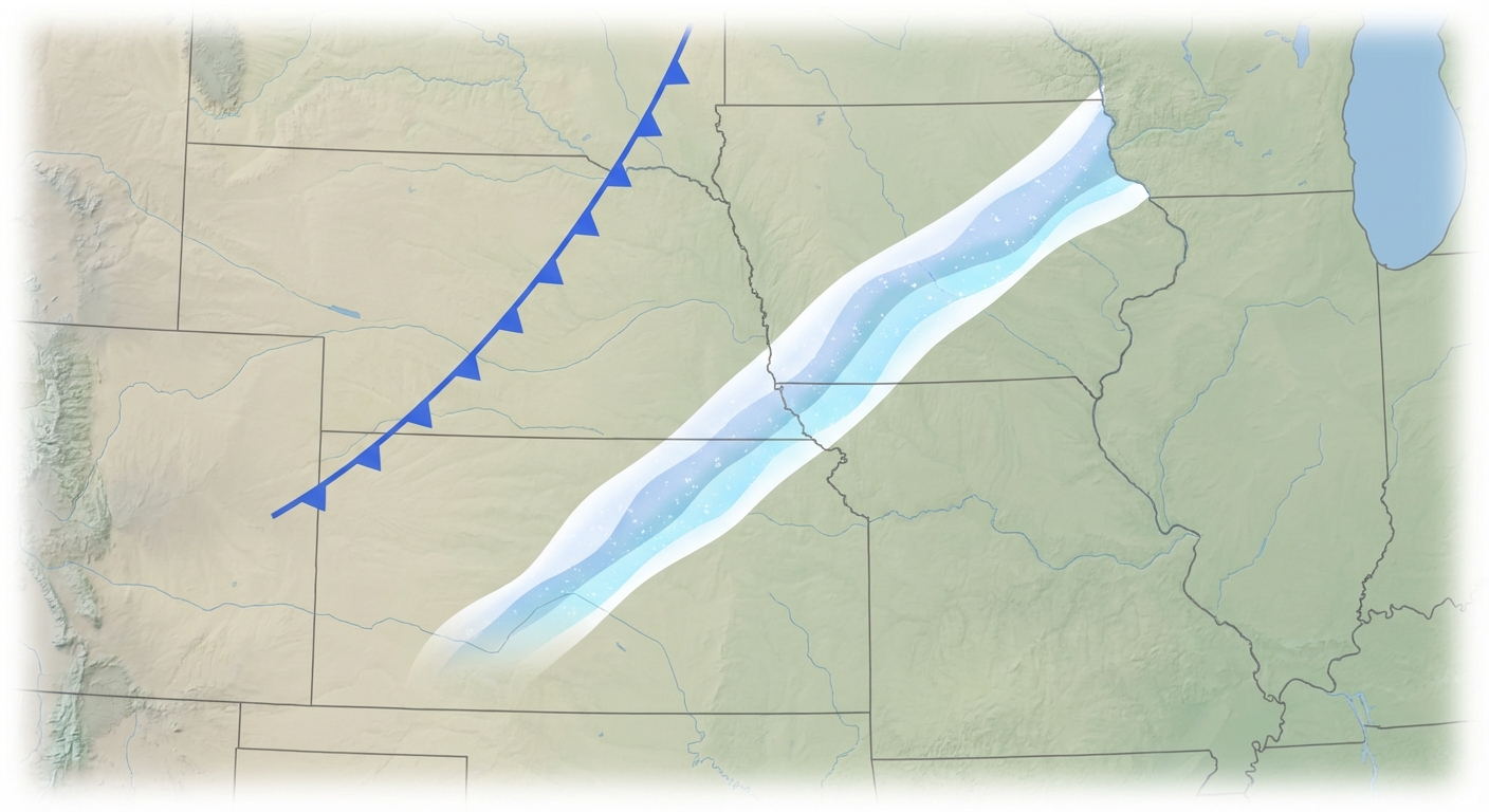
Here's the thing about April, though. It loves to throw a curveball. We're watching a very narrow, intense band of heavy snow setting up later today.
A cold front dropping through the Missouri Valley is going to stall out and interact with some upper-level energy. This means folks from eastern Nebraska through southwest Iowa and into northern Missouri could see a quick burst of heavy snow tonight into Tuesday morning. The Weather Prediction Center is highlighting this area for impressive snowfall rates. If you commute along I-80 or I-35 in those areas tomorrow morning, leave early. The roads will get slick.
Fire Today, Storms Tomorrow
Out west, the pattern is getting active again. We still have a Critical Fire Weather area today for the central and southern High Plains. Cities like Liberal, Kansas, and Guymon, Oklahoma, are dealing with 20 to 25 mph winds and humidity dropping down to 10 percent. Please don't burn anything outside today.
By Wednesday, that same region transitions into a severe weather threat. The Storm Prediction Center has a Marginal Risk posted for the Central Plains. A cold front will stall over northern Kansas, and we expect isolated elevated supercells to fire off Wednesday night. Large hail is the main threat there.
Looking further ahead, things get more organized. SPC already has a 15 percent probability area highlighted for severe storms on Saturday across the Southern Plains. This includes Lubbock, Amarillo, and Oklahoma City. Moisture is going to surge northward off the Gulf, and the upper-level winds look supportive for severe thunderstorms. It's a 'have your plan ready' kind of setup for the weekend.
Key Factors We Are Watching
- Florida Rain: Stalled front keeps a Marginal Risk for flash flooding over the peninsula through mid-week.
- Midwest Snow: A narrow but intense band of snow impacts eastern Nebraska, southwest Iowa, and northern Missouri tonight.
- Plains Fire Threat: Critical fire weather today for the Oklahoma and Texas Panhandles into southwest Kansas.
- Weekend Severe Potential: A 15% severe risk is already marked for Saturday across the Southern Plains.
Bottom Line
Enjoy the pristine weather if you're under that big high pressure system today. Midwest folks, keep the ice scraper handy for one more morning. And if you live in the Plains, use these quiet days to review your severe weather safety plan before the weekend gets here.