Blog Article
Texas Flood Risk: High Risk Today, Moderate Risk Thursday
WPC's High Risk of excessive rainfall returns to the Texas Hill Country and San Antonio area today, with a Moderate Risk following Thursday as an MCV lingers.

Texas Hill Country Isn't Out of the Woods: High Risk Today, Moderate Risk Tomorrow
Alright y'all, let's not bury the lede here. Texas is still the story, and it has been all week. Y'all remember yesterday, we talked about the Northeast's severe setup taking center stage, but overnight and into this morning, the real headline snapped right back to the Edwards Plateau, the Hill Country, and the central Rio Grande Valley. WPC has a HIGH Risk of excessive rainfall posted for that corridor today, and get this, tomorrow's outlook actually keeps a MODERATE Risk going as the disturbance responsible for this mess continues to loiter right where it's been sitting since Monday.
What's Actually Happening Here
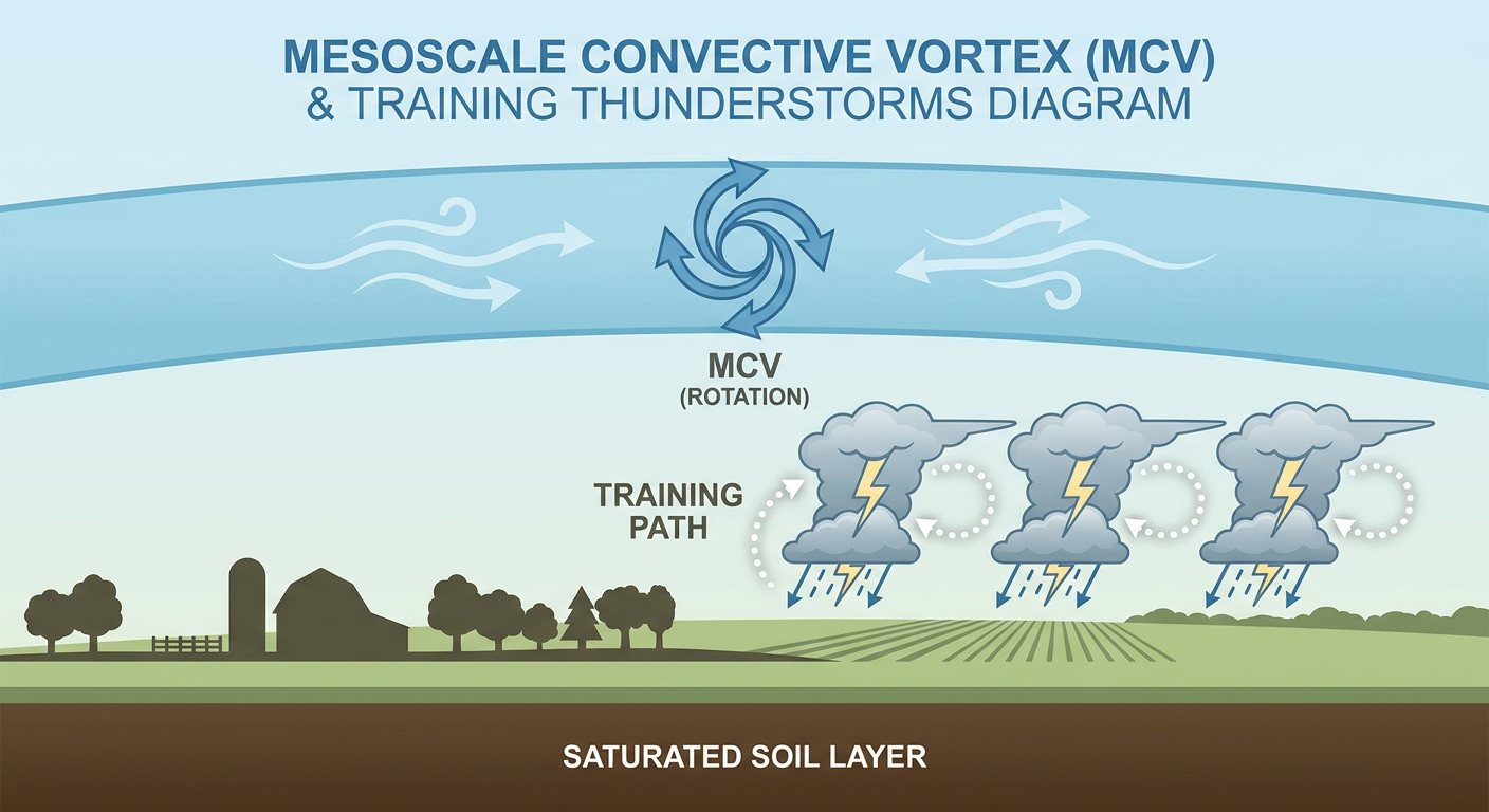
There's a low to mid-level circulation, what forecasters call a mesoscale convective vortex or MCV, parked over the Edwards Plateau and Hill Country, right along and north of US-90 west of San Antonio. This thing has been feeding training thunderstorms, meaning storm after storm rolls over the exact same ground, for days now. Ground that's already saturated from Tuesday and Wednesday's rain. That's the recipe for flash flooding, and it's exactly what played out yesterday.
Just look at what came in during the last 24 hours. Multiple roads closed in Navasota with reports of homes and vehicles swept away. Four high water rescues in Medina County. A tornado warning fired for Bexar County. A funnel cloud spotted near Olmos Park late last night. Leon Valley on the northwest side of San Antonio dealing with flooded low water crossings well past midnight. This isn't a one-day event. This is a system that's been grinding on this region since Monday, and today it's not letting up.
Timeline and Who's Affected
- Today (Day 1, High Risk): Edwards Plateau, central Rio Grande Valley, and Hill Country. The MCV may drift south toward the San Antonio metro itself, which raises urban flash flood concerns for a city that already took a beating overnight.
- Thursday (Day 2, Moderate Risk): Same general area. WPC says convection will continue for at least one more period, with another round of nocturnal storms possible into Thursday morning before things start to relax.
- Friday (Day 3, Slight Risk): The pattern finally starts to decay as the upper trough over West Texas weakens. Risk area shifts and shrinks to cover much of West Texas, southern New Mexico, Arizona, and the southern Great Basin, with lingering elevated moisture still capable of one more round.
Additional rainfall of 2 to 4 inches on top of ground that's already full is the concern here. That's not a huge number by itself, but when the soil can't absorb another drop, it doesn't take much to turn a creek into a hazard.
Elsewhere Around the Country
Compared to Texas, everything else today is pretty tame.
- Mid-Atlantic and New England: SPC has a Marginal Risk up for parts of New York, Philadelphia, and Newark today, mainly large hail and damaging wind gusts Wednesday afternoon and evening. There's a hatched area tucked in there too, meaning if a storm does go severe, an isolated tornado reaching EF2 strength isn't impossible, though that's a low-probability, high-impact scenario, not the headline. Mets at Phillies tomorrow night in Philadelphia falls right in this window, so keep an eye on the radar if you've got tickets.
- Arizona: Also Marginal today, monsoonal storms capable of gusty downbursts. Phoenix is in the zone.
- Western Montana: Marginal Risk Thursday, strong to severe storms possible around Missoula, Great Falls, and Helena. This is the same general region that saw an 86 mph gust and 2.5-inch hail near Hobson and Lewistown overnight, so the ground's already primed for another round of reports up there.
- Fire weather: Elevated conditions continue in northeastern California, south-central Oregon, and northwestern Nevada, plus a dry thunderstorm risk across Washington and the northern Idaho panhandle where a 50 to 60 knot mid-level jet could spark fires without much rain to go with the lightning.
Heat and Comfort Check
If you're not under one of those rain or storm zones, the bigger story is just heat and humidity. Dewpoints are running 55 to 73°F across a big chunk of the country today, and heat indices are topping 90 to 110°F in spots, mainly the Midwest, Plains, and Eastern Seaboard. That's on the heels of South Dakota hitting 108°F and Michigan's Upper Peninsula climbing into the upper 90s and low 100s just yesterday, so this heat pattern isn't new, it's just persistent. For reference, Dallas and San Antonio's normal July high sits around 96 to 97°F, so if you're down in Central Texas today, the rain and cloud cover from all this convection is probably keeping temperatures a notch below where they'd otherwise be this time of year. Small mercy given everything else going on down there.
The best weather in the country tonight, if you're looking for it, sits in that Boise to Spokane to Salem to Kalispell corridor of the Intermountain West, where dry, sinking air keeps things comfortable and clear.
Tropical Watch
Nothing organized yet, but three weak invests are on the board. Two sit way out in the Central Pacific near 10°N (Invest 90CP and 91CP), and one's churning in the Eastern Pacific off Mexico (Invest 96EP). All three are running 25 to 30 knots, basically disorganized clusters of thunderstorms, and none are an immediate threat to land. Worth watching over the coming days, not worth losing sleep over tonight.
Space Weather
Quiet story here too. SWPC says geomagnetic conditions stay below G1 levels through mid-August, with a small chance of M-class solar flares as some active regions rotate into view. Nothing that'll disrupt your GPS or your weekend plans.
What We're Watching
- Whether that MCV over the Hill Country drifts far enough south to put urban San Antonio squarely in the bullseye for flash flooding
- Additional rainfall totals in the 2 to 4 inch range on top of already-saturated ground in the Edwards Plateau and RGV
- Whether Thursday's Mid-Atlantic storms complicate travel or ballgames in the Philadelphia and New York corridor
- Montana's severe threat Thursday afternoon and evening, given how active that region's been the last 24 hours
- Any organization out of the three tropical invests in the Pacific over the coming week
Bottom Line
If you're anywhere near San Antonio, the Hill Country, the Edwards Plateau, or the central Rio Grande Valley, today is not a day to test a low water crossing. This isn't a new threat, it's the same flood-prone setup that's been grinding on this part of Texas since Monday, and WPC's High Risk designation for today plus a Moderate Risk tomorrow means forecasters expect this to keep going, not wind down. Everywhere else, today's a pretty ordinary summer day: watch for scattered strong storms in the Northeast, Arizona, and Montana, and expect the heat and humidity to be the main character if you're not under one of those risk zones.