Blog Article
Arctic Outbreak Continues: Lake Effect Snow & Southern Ice Risk
Significant lake effect snow hits NY while dangerous cold grips the Plains. Plus, a winter storm eyes the South this weekend. Get the latest forecast.
The Arctic Express Rolls On: Historic Lake Snow & A Southern Mess Brewing
Alright folks, grab a hot cup of coffee and pull up a chair because we need to talk. If you thought last week was wild with snow falling all the way down in the Florida Panhandle, get this. The atmosphere is reloading for round two. We are stuck in a pattern dominated by what we call the "Hudson Bay vortex." That's just a fancy way of saying a massive swirl of cold air is parked up north, and it keeps sending piece after piece of Arctic air right into our backyards.
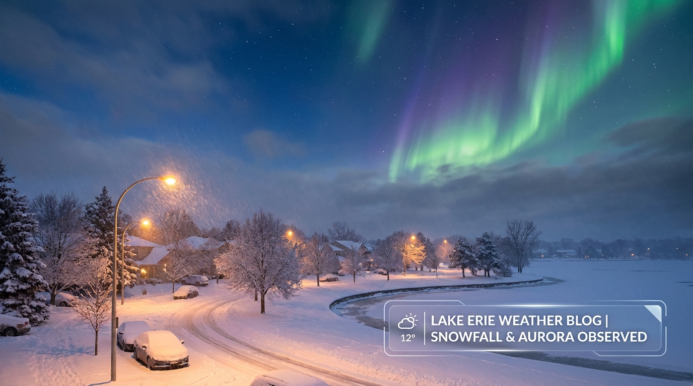
Here is the thing, while some of y'all are shivering, folks up near the Great Lakes are burying their cars.
The Lake Effect Snow Machine is Wide Open
Let's start with the immediate headache. Cold air is rushing over the relatively warmer waters of Lake Erie and Lake Ontario, and the result is explosive. We are talking about snowfall rates of 2 to 4 inches per hour. That is not just "winter wonderland" snow, that is dangerous travel-stopping snow.
If you are in the Buffalo Southtowns or up on the Tug Hill Plateau, you could see localized amounts of 2 to 4 feet by Tuesday morning. Yes, you read that right. Feet. If you have travel plans near I-90 or the snow belts, you need to be extremely careful. This is whiteout territory.
The Midwest Deep Freeze
For my friends in the Upper Midwest and Northern Plains, the story is the cold. We have wind chills dropping into the -30s and even -40s in the Dakotas and Minnesota. That is frostbite-in-minutes kind of cold.
There is also a "clipper" system diving down through Tuesday and Wednesday. It's a fast-moving system that's going to drop a quick 2 to 4 inches of fluffy snow across northern Iowa, southern Wisconsin, and into Michigan. It's not a blizzard, but with those temperatures, the roads will get slick fast.
I saw there is a "Nature Prescription" outdoor event scheduled in Osceola, WI for Thursday. Folks, the data shows wind chills could be brutal. You might want to take that prescription indoors or bundle up like an astronaut.
The Big Question: A Southern Mess This Weekend?
Now, let's look ahead to the weekend because this is what has my attention. We have all this cold air established across the central and eastern U.S. It is heavy and stubborn. By Friday, a new storm system is going to eject out of the Southwest. It's going to try to pull moisture from the Gulf of Mexico up over that cold dome.
When warm moisture overrides freezing air at the surface, you get a mess. We are watching a growing signal for a winter storm stretching from the Southern Plains into the Mid-South and eventually the Mid-Atlantic Friday through Sunday.
Here is what we are watching for the South:
- Texas & Oklahoma: Friday looks tricky. We could see a transition from rain to sleet and snow. If you are heading to the San Antonio Coffee Festival events early, keep an eye on the roads.
- Tennessee Valley to the Carolinas: By Saturday and Sunday, this moisture moves east. The setup favors ice or sleet in some areas where that cold air refuses to budge. This could impact travel significantly.
It is too early to promise snow totals or ice accretion numbers, but the signal is there. This looks like a classic "overrunning" event where the cold air wins the battle at the surface.
Bonus: Look Up!
One bright spot in all this active weather is the space weather. We have had some major solar flares recently, and the Space Weather Prediction Center says we could see geomagnetic storms reaching G1 to G4 levels. If the skies clear out between these snow bands, folks in the northern tier might get a spectacular light show with the Aurora Borealis tonight and tomorrow.
Bottom Line
If you are near the Great Lakes, stay off the roads if you can. If you are in the Plains, cover exposed skin. And for everyone in the South from Texas to Virginia, pay close attention to the forecast for Friday and Saturday. This winter pattern is not giving up without a fight.
Stay safe out there, y'all!
https://ryanhallyall.com/blog/the-arctic-express-rolls-on-historic-lake-snow-a-southern-mess-brewing