Blog Article
Midwest Severe Weather Threat Moving East Tomorrow
A major storm system brings a severe weather and tornado threat to the Midwest and Texas today before shifting to the Ohio Valley and Mid-Atlantic tomorrow.

The Midwest Severe Threat Is Here, And It's Moving East Tomorrow
Alright folks, let us talk about what is happening right now. Yesterday we discussed those wild viral Michigan tornado videos and warned you that another dangerous setup was targeting the Midwest for Tuesday. Well, Tuesday is officially here, and the atmosphere is absolutely loaded.
Here is the thing. We are looking at a massive, multi-hazard storm system today. It is bringing severe weather to the heartland, a literal blizzard to the Pacific Northwest, and a nasty ice storm up to New England. Let us break down exactly what you need to know and how this is going to impact your week.
The Midwest and Texas Danger Zone Today
For today, the Storm Prediction Center has outlined a Level 3 out of 5 Enhanced Risk for severe thunderstorms in two main areas.
The first area covers northern Missouri, straight across northern Illinois, and into northwest Indiana. Yes, that includes the entire Chicago metro area. We have a sharp cold front colliding with some really warm, spring-like air. When that happens, the atmosphere gets angry. We are looking at the potential for very large hail, damaging winds, and a few strong tornadoes.
The second Enhanced Risk area is down in the Texas Plains, right over Dallas and Fort Worth. If you are driving home from work this evening in either of these zones, you need to keep your head on a swivel. Leave early for your commute if you can, and make sure you have a way to get warnings that will actually wake you up if storms roll through after dark.
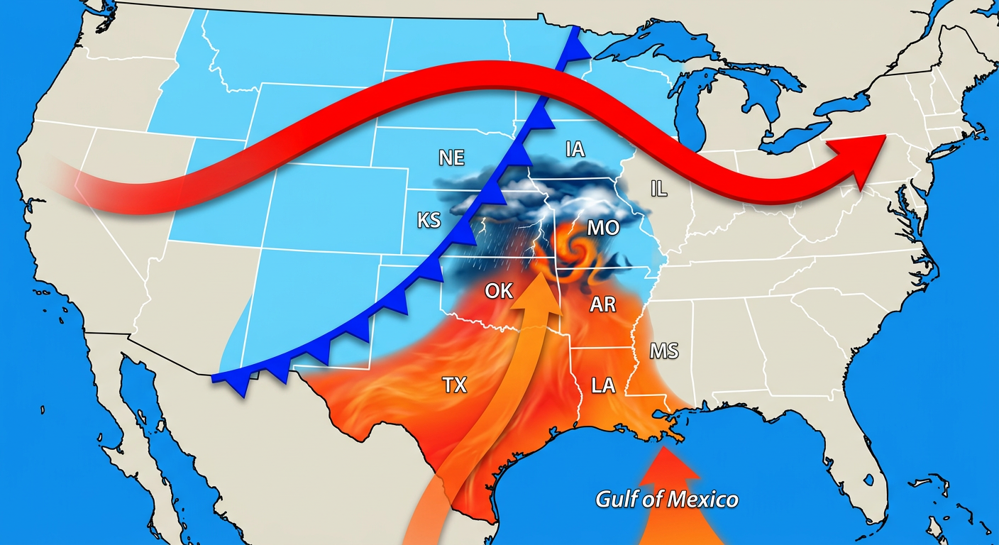
Also, if you are down in East Texas or Louisiana getting things set up early for the Houston Crawfish Day Fest this weekend, expect some soggy ground. There is a Slight Risk for excessive rainfall and flash flooding in that area today into tomorrow.
The Eastward Shift on Wednesday
This system does not just vanish after tonight. Tomorrow, the whole mess pushes east.
We have a Level 2 out of 5 Slight Risk covering a huge area from the ArkLaTex region, up through the Lower Mississippi Valley, across the Ohio Valley, and right into the Mid-Atlantic.
- Cities to watch: Memphis, Nashville, Columbus, Baltimore, and Washington DC.
- The main threats: Widespread damaging winds and a few isolated tornadoes.
- The temperature swing: You are going to go from keeping the AC running to digging out your hoodies in a matter of hours. Expect a sharp 15 to 30 degree temperature drop right behind this front.
Winter Is Not Done Yet
While the eastern half of the country is dealing with spring severe weather, the northern tier is getting a harsh reminder that it is still technically winter.
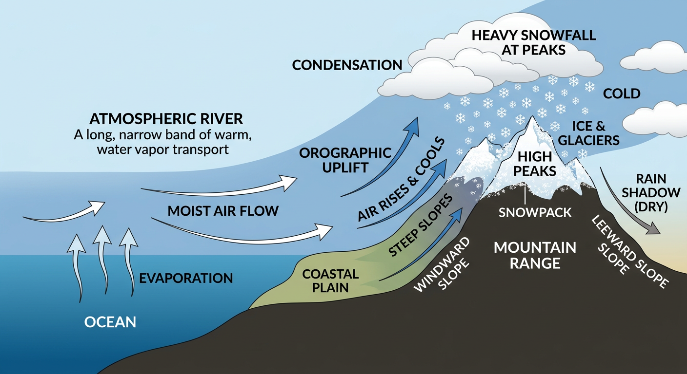
Get this. We have a powerful atmospheric river slamming into the Pacific Northwest. The Washington Cascades are under Blizzard Warnings. We are talking about storm total accumulations of 2 to 5 feet of snow in the higher elevations. If you have travel plans through the mountain passes, you might want to rethink them because travel is going to be nearly impossible.
Way over on the other side of the country, northern Maine is bracing for a significant winter storm of its own. Cold air is trapped at the surface, which means they are looking at 1 to 4 inches of sleet and freezing rain tonight into Wednesday. That is the kind of heavy ice that brings down tree branches and causes power outages, so make sure your devices are charged up.
Bottom Line
Y'all need to pay close attention to the weather today and tomorrow. If you are in the Midwest or Texas today, have your severe weather safety plan ready to go. If you are in the Ohio Valley or Mid-Atlantic, prepare for a bumpy and windy Wednesday. And if you are in the Cascades or northern Maine, hunker down and stay off the roads. Stay safe out there, and keep an eye on the sky!
https://ryanhallyall.com/blog/the-midwest-severe-threat-is-here-and-its-moving-east-tomorrow