Blog Article
Severe Weather Today: 58M at Risk from Atlanta to Philadelphia
Slight Risk covers 58 million from the Southeast to Mid-Atlantic today with damaging winds, large hail, and isolated tornadoes. High Plains severe threat Tuesday and Wednesday.

The Outbreak Moves East: 58 Million in Today's Severe Crosshairs
Alright y'all, if you were with us yesterday, you know what happened. A major tornado outbreak tore across southern Illinois and Indiana. Two PDS Tornado Warnings in Jefferson County, Illinois. A supercell that tracked for over two and a half hours. A confirmed fatality in Sedgwick, Kansas. It was one of the worst days of an already brutal June.
Now that system is pushing east, and today the threat lands right on top of the most populated corridor in the country.
Today's Setup: Mid-Atlantic and Southeast
The SPC has a Slight Risk posted from the Southeast up through the Mid-Atlantic. We're talking about 316,000 square miles and roughly 58 million people. The major cities in the crosshairs? Philadelphia, Charlotte, Washington DC, Baltimore, and Atlanta.
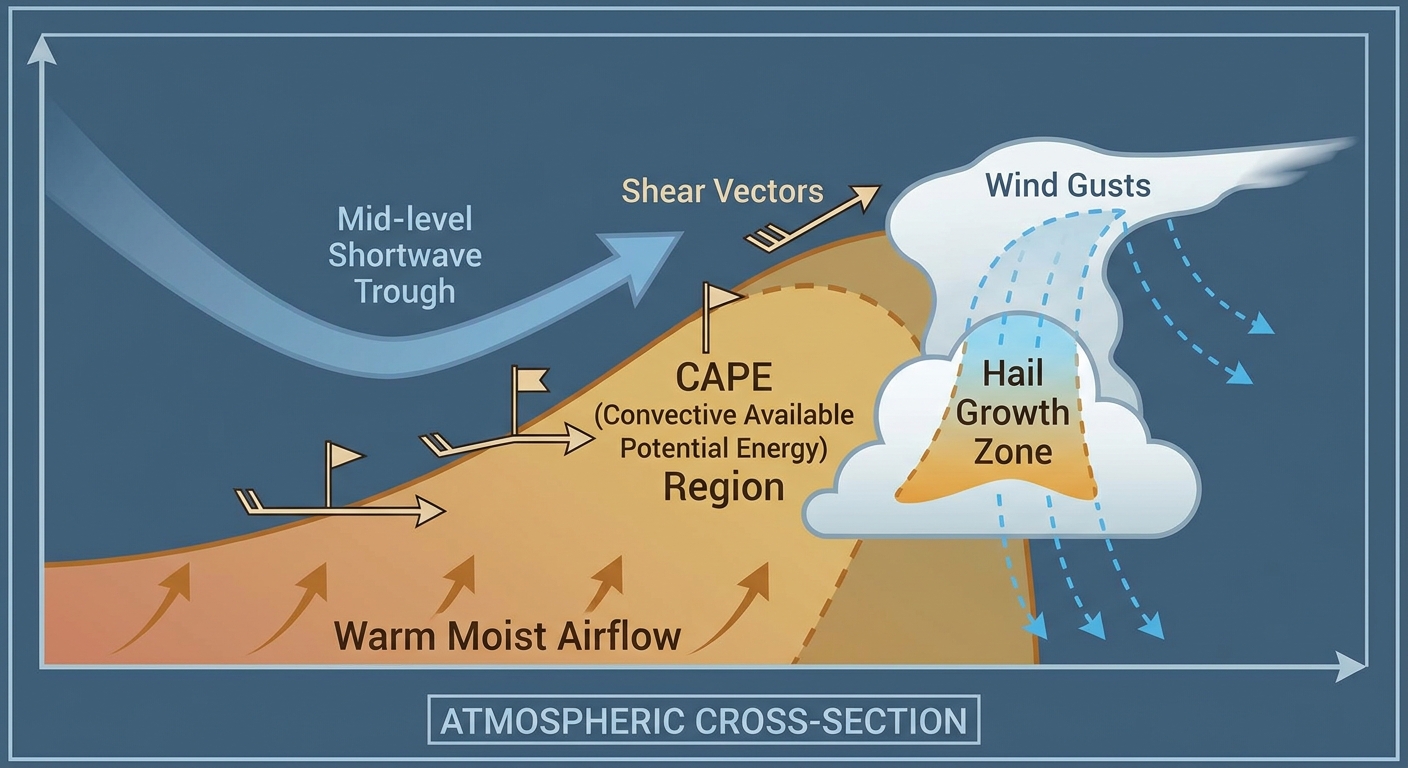
Here's what the atmosphere is doing. A potent mid-level shortwave is sliding southeast through the Central and Southern High Plains this morning, and it's going to interact with a warm, humid air mass sitting over the eastern third of the country. That boundary layer instability is already looking juicy, and as we heat up this afternoon, storms are gonna fire.
The main threats today:
- Damaging wind gusts: 15% probability (Level 2, scattered). SPC is flagging 60+ mph gusts where storms organize.
- Large hail: 15% probability (Level 2, scattered). Inside the hatched area, hailstones could reach 2 inches, hen-egg size. That's roughly 6.5 million people in that hatched zone.
- Tornadoes: 2% probability (Level 1, isolated). If storms can stay discrete ahead of the main line, an isolated tornado or two is not out of the question, especially along any boundaries that set up.
Now, why should you care beyond the forecast? Because there are MLB games today right in the risk area. The Phillies are in Washington to play the Nationals at 6:45 PM. The Cubs are at the Mets in Queens, which sits in the Marginal Risk. The Brewers are in Cincinnati, also Marginal. If you're heading to any of those games, keep an eye on radar and have a plan for getting to shelter if storms roll through during the game.
And if you're commuting on I-95 between DC and Philadelphia this afternoon, leave yourself some extra time. These storms will be moving through during peak heating, which means right around rush hour.
Excessive Rainfall: Southern Plains to Northeast
The WPC has a Slight Risk of excessive rainfall stretched from the southern Plains all the way to the Northeast today. That's a big footprint. The discussion mentions a mid-level shortwave sliding southeast through the Central and Southern High Plains with favorable boundary layer instability downstream into the Lower Mississippi Valley and southwestern Tennessee Valley through the afternoon.
This matters because we've already had catastrophic flooding this month. Tropical Storm Arthur dumped 26 inches on parts of Louisiana. The Anker Lake Dam failed in Mississippi. Soils across the South are still saturated. Any additional heavy rain is going to run off fast, and flash flooding can develop quicker than you'd think.
If you're in the ArkLaTex or along the I-20 corridor, pay attention today. Training storms could easily produce 2 to 3 inch per hour rates in the worst cells.
Days 2 and 3: High Plains Takes the Stage
While the East deals with today's mess, the focus shifts back to the High Plains for Tuesday and Wednesday. And this is a different flavor of severe weather.
SPC has a Slight Risk for Tuesday covering eastern Colorado into western Kansas and northern Oklahoma. Denver, Wichita, and Cheyenne are the major cities highlighted. The setup here is persistent moderate to strong mid-level west-northwesterly flow, 40 to 50 knots, over the central High Plains. That kind of flow aloft combined with upslope terrain is a classic recipe for supercells.
The threats Tuesday:
- Very large hail: 15% probability (Level 2). Hatched area says 2+ inch hail possible. That's hen-egg size or bigger.
- Damaging wind: 15% probability (Level 2). Hatched area indicates 75+ mph gusts possible in the strongest cells.
- Isolated tornado: 2% probability (Level 1).
Wednesday looks like a repeat. Slight Risk again for the central High Plains, centered on Denver, Colorado Springs, Pueblo, and Cheyenne. The SPC discussion says scattered severe storms are likely with a threat for large to very large hail. If you're in that area, Tuesday and Wednesday are both days to have your weather radio on and your plan ready.
The Red Sox are in Denver to play the Rockies on Tuesday evening. First pitch is scheduled for 6:40 PM local. If you're going to that game at Coors Field, just know that storms could be firing right around gametime. Coors Field has had its share of weather delays over the years.
Fire Weather: Four Corners and Great Basin
Out west, fire weather is a growing concern. The SPC Day 2 Fire Weather Outlook highlights a Critical area for portions of northern Arizona into southern Utah on Tuesday. We're looking at 15 mph sustained west-southwesterly surface winds combining with 10 to 15 percent relative humidity over dry fuels. That's a dangerous combination.
The Iron Fire near Eureka, Utah was upgraded to catastrophic intensity yesterday with mandatory evacuations and confirmed structural loss. Any new ignitions in this environment are going to spread fast.
Space Weather: Quiet But Watching
SWPC says the geomagnetic field is expected to stay mostly quiet today and tomorrow. Solar activity was actually high yesterday with an M6.8 flare from Region 4473, which produced an R2 Moderate radio blackout. That same region is still showing flare potential, with an increasing chance for M-class flares over the next couple of days. Nothing actionable for most folks, but if you're into HF radio or aviation, that's your heads up.
Looking further out, the 27-day outlook shows a potential G1 Minor geomagnetic storm on July 3rd with a peak Kp of 5. Not a big deal, but it could mean some aurora visibility at high latitudes around Independence Day.
A Quick Word on This Month
Y'all, June 2026 has been absolutely relentless. We've had near-continuous severe weather across the eastern two-thirds of the country since June 1st. Measured wind gusts of 113 mph in Salina, Kansas. A PDS Tornado Emergency in Illinois on June 11th. Tropical Storm Arthur making landfall on the 17th. Yesterday's tornado outbreak with PDS warnings in Jefferson County. And now today's Slight Risk over 58 million people.
The analog data backs this up. The last two Junes each produced over 250 tornado reports nationally, well above the long-term average of 188. Maryland saw nine tornado reports last June, triple the state's June average. The Mid-Atlantic can get busy when the pattern aligns, and today that pattern is aligned.
Bottom Line
If you're in the Slight Risk area today from Atlanta up through the Mid-Atlantic, here's what to do:
- Have your phone charged and weather alerts enabled. Wireless Emergency Alerts will ping you for Tornado Warnings. Make sure those notifications are turned on.
- Know where your safe space is. Interior room, lowest floor, away from windows. If you live in a mobile home, figure out now where you'd go if a warning is issued.
- If you're at an outdoor event or MLB game today, know the venue's shelter plan. Don't wait until the sky turns green to figure out where to go.
- If you're in the ArkLaTex or Gulf Coast states, watch for flash flooding. Turn around, don't drown. It sounds cliché because it's true.
- If you're in the central High Plains, Tuesday and Wednesday are your days to prepare. Denver, Cheyenne, eastern Colorado. Very large hail and 75+ mph winds are possible.
This pattern doesn't look like it's letting up anytime soon. The WPC has Slight excessive rainfall risks posted for three straight days from the southern Plains to the lower Mississippi Valley. We'll keep tracking it.
https://ryanhallyall.com/blog/the-outbreak-moves-east-58-million-in-todays-severe-crosshairs