Blog Article
Polar Vortex Split Causes Extreme US Weather Whiplash
The Polar Vortex just split thanks to a Sudden Stratospheric Warming event. Find out why Texas is hitting 104 degrees while the Northeast is buried in snow.
The Polar Vortex Just Broke In Half (And It Is Wrecking The Map)
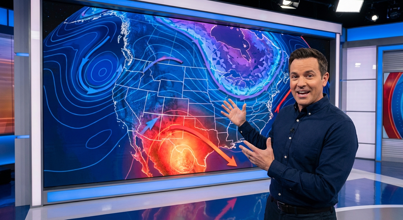
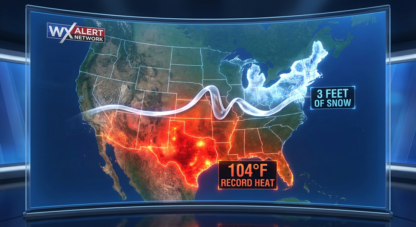
Alright folks, get this. If you looked at a weather map of the United States today, you would think the simulation is glitching. We have people down in Laredo, Texas sweating through 104-degree heat. That is the first triple-digit reading of 2026, and it is still February. Meanwhile, folks up in Rhode Island and New York are still trying to dig their cars out from under three feet of snow from the Blizzard of 2026. Oh, and Los Angeles just hit 91 degrees right after being underwater from historic flooding.
What in the world is going on? Here is the thing. The atmosphere is completely out of whack right now, and it all comes down to something called a Sudden Stratospheric Warming event.
The Polar Vortex Split Explained
You have probably seen the memes flying around TikTok today about the weather being broken. Well, the culprit is 20 miles above our heads. The Polar Vortex just broke in half.
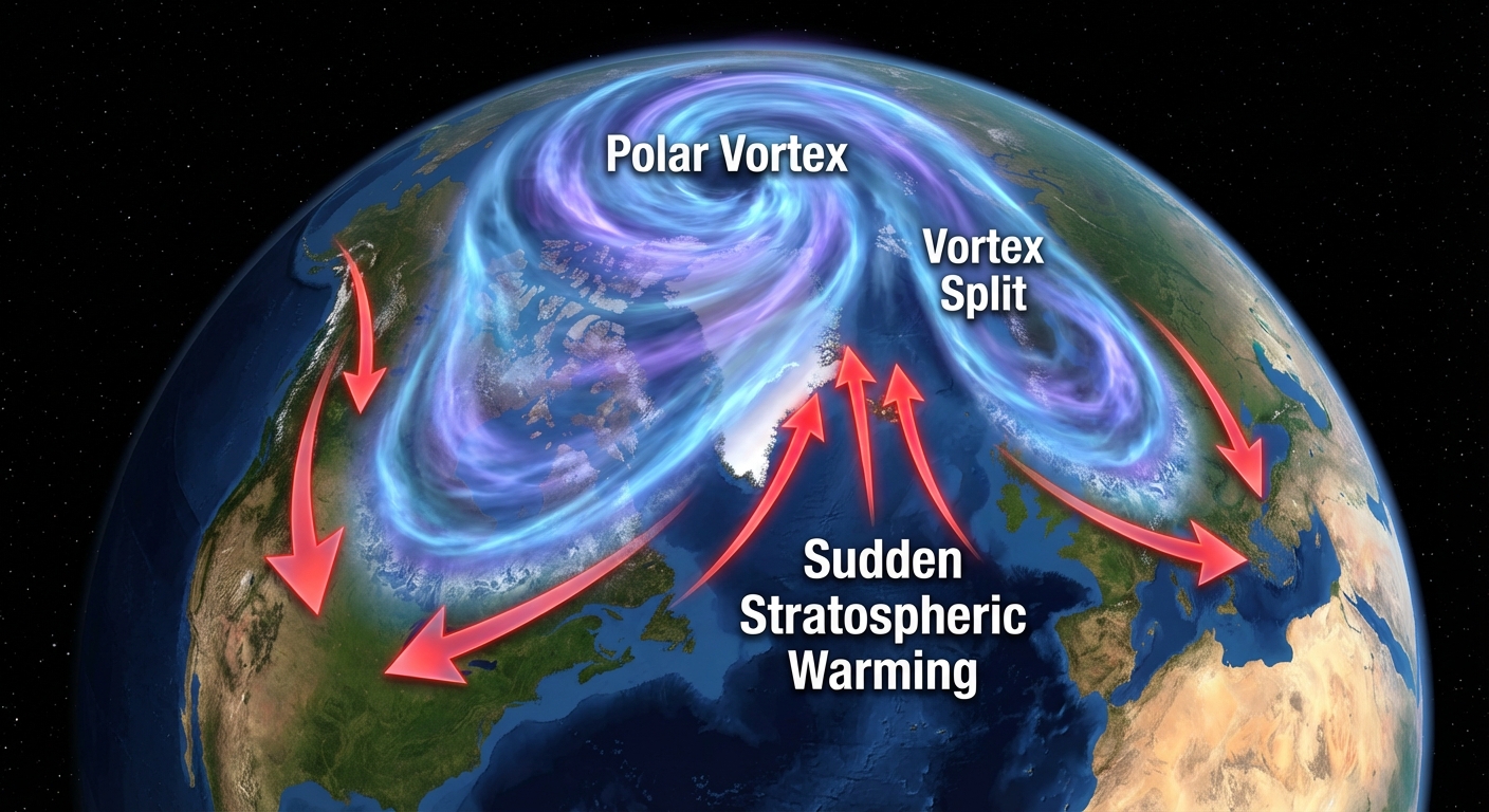
Normally, the Polar Vortex is a tight, spinning top of freezing air locked right over the North Pole. But a Sudden Stratospheric Warming event essentially just body-slammed it. Temperatures high up in the stratosphere spiked rapidly, and that forced the vortex to split into two separate lobes. When that spinning top breaks, all that frigid Arctic air has to go somewhere, and it spills right down into the lower latitudes.
That is exactly why the weather map looks like a patchwork quilt of extremes right now. The jet stream is buckling hard. It is pulling scorching summer heat up into Texas while dumping historic blizzards on the Northeast.
Florida Storms and Spring Training
Speaking of weird weather, let us talk about Florida. If you are down there for the weekend checking out some Grapefruit League Spring Training baseball games, you need to keep your head on a swivel this evening. We have a Marginal Risk for severe weather draped right across Central and South Florida.
A cold front is stalling out near the I-4 corridor. We are already seeing some isolated strong thunderstorms popping up, and they could bring some gusty winds and maybe a little hail to places like Miami and Fort Lauderdale. It is nothing catastrophic, but it is definitely enough to delay a baseball game or ruin your evening cookout.
What is Coming Next?
Do not think we are done with winter just because Texas is baking. As we look ahead to Sunday and Monday, a brand new system is going to slide cold, high pressure into the northern tier.
- The Ohio Valley to the Northeast: We have a wintry mix pushing through. The Adirondacks and Berkshires could see another couple of inches of snow. It is not going to be another 37-inch snowstorm, but it will make the roads slick.
- The Southern Plains: A quasi-stationary front is setting up from Texas to the Mid-South. That is going to trigger more showers and thunderstorms through the start of the week. In fact, by Wednesday, we are looking at a 15 percent severe weather risk for places like Dallas and Fort Worth.
- Space Weather: Get this. We are also expecting a G1 Minor Geomagnetic Storm tonight. A coronal mass ejection is arriving, so if you live up north, you might just catch the Northern Lights if the skies clear up.
The Bottom Line
Y'all, this Polar Vortex split means March is going to come in like a lion with an identity crisis. We are going to see wild temperature swings, active storm tracks, and a whole lot of climate whiplash. Keep your winter coats handy, but maybe do not pack away the shorts just yet.
Stay weather aware, and I will see y'all in the next update.
https://ryanhallyall.com/blog/the-polar-vortex-just-broke-in-half-and-it-is-wrecking-the-map