Blog Article
West Coast Weather Whiplash: Atmospheric River & Record Heat
The eastern severe weather threat is over, but a massive atmospheric river is bringing blizzards to the Cascades while the Southwest faces record heat.
The Severe Threat is Fading, But The West Coast is About to See Extreme Weather Whiplash
Alright folks, we finally made it through one of the wildest severe weather weeks I have seen in a long time. As we talked about yesterday, that "false spring" setup fueled an absolute monster of a storm system. From that unbelievable 5.2-inch hailstone in Kankakee to the 80 mph squall line that hammered the Mid-Atlantic, it has been a relentless few days. If you are heading out to the Cherry Blossom Festival in Washington D.C. this weekend, you will be happy to know the worst of the wind and rain has finally pushed offshore.
But here is the thing. The atmosphere never really stops working. Now that the eastern half of the country is getting a much-needed breather, the West Coast is stepping up to the plate with some serious weather whiplash of its own.
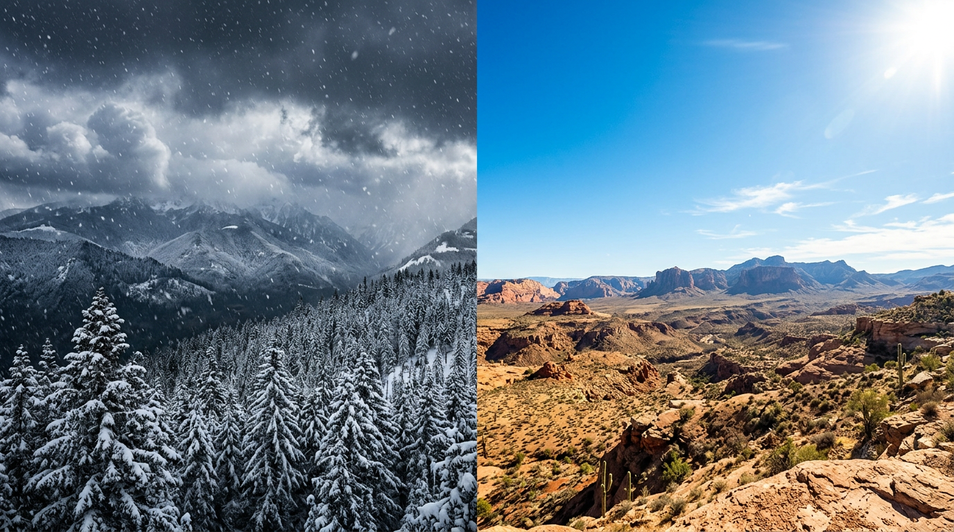
The Great Western Divide: Blizzards and Baking Heat
Get this, we are looking at a classic split pattern out West over the next few days. Up north, a powerful atmospheric river is pointing a firehose of Pacific moisture right at Washington and Oregon. Down south, a massive ridge of high pressure is building in, bringing a taste of mid-summer heat to the desert.
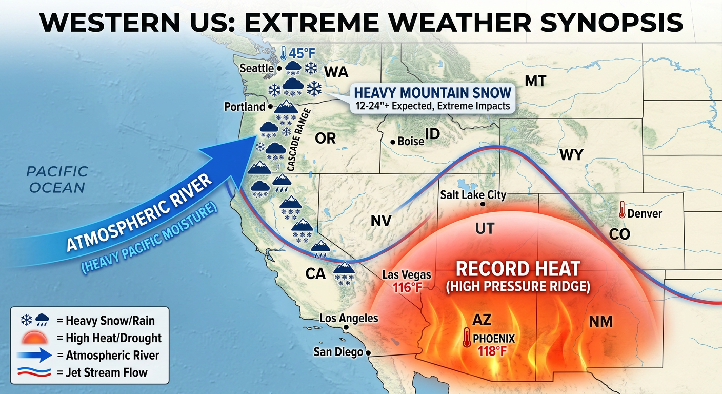
Let's start with the Pacific Northwest. This atmospheric river is not messing around. It is bringing heavy coastal rain and absolutely burying the high elevations. We have Blizzard Warnings in effect for the Washington Cascades today, and they are looking at 1 to 3 feet of snow up there. If you are trying to travel through the mountain passes, you need to rethink those plans. And if you are hanging out in the lower elevations for the Brujos Brewing anniversary event in Portland this weekend, bring your rain gear. It is going to be soggy.
Now, swing your attention down to the Southwest and California. It is a completely different world. That high-pressure ridge is going to crank up the thermostat, bringing unseasonably warm and potentially record-breaking temperatures by the weekend. We are talking about highs pushing into the 90s in some spots. If you are heading out to the Tasty Nights Street Food Festival in Mesa, Arizona, this weekend, you are going to want to dress light and stay hydrated.
The Sneaky Great Lakes Clipper
I can't forget about my friends in the northern tier. While the big storms are gone, a fast-moving, intense little clipper system is diving out of the Northern Plains today and sweeping into the Great Lakes by tonight.
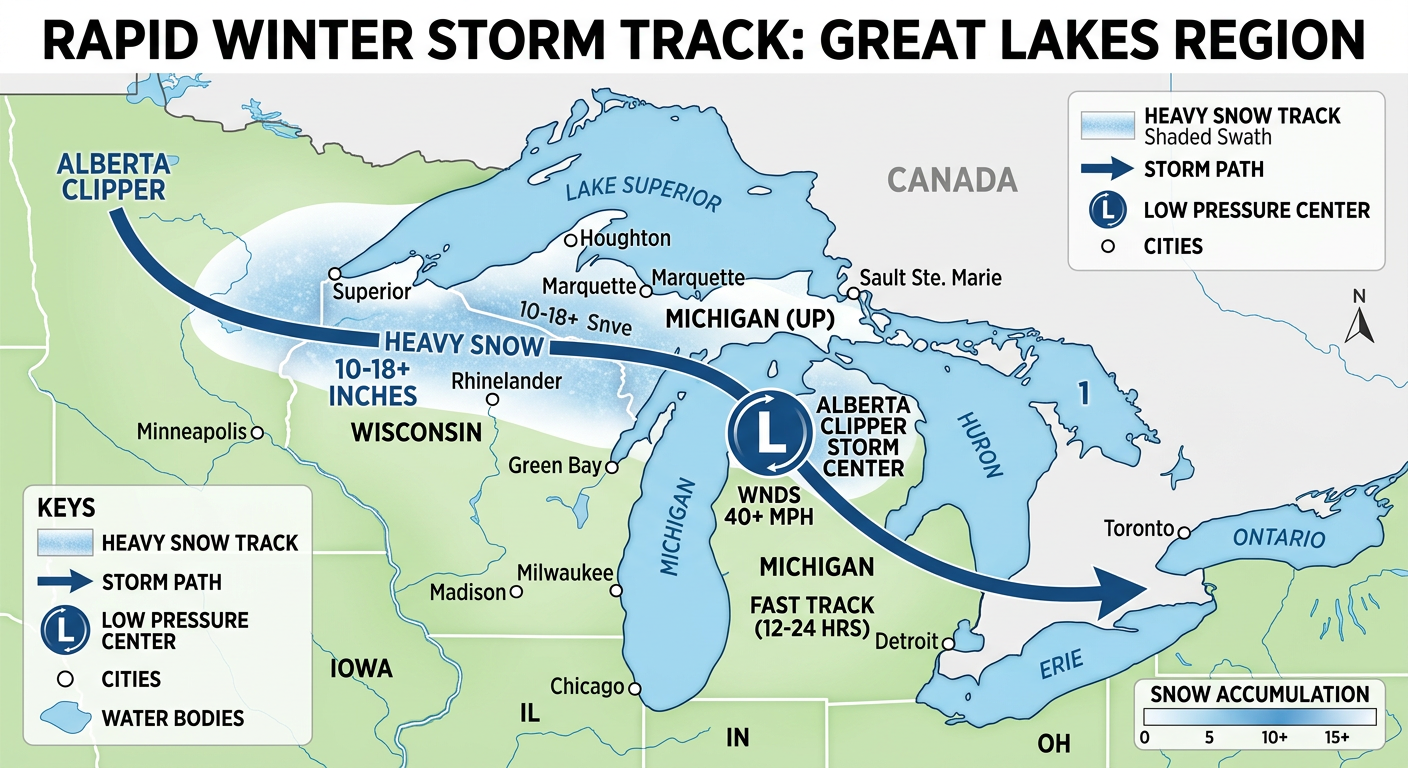
This system is going to bring a quick but heavy swath of snow, especially across northern Wisconsin and the Upper Peninsula of Michigan. We are expecting a solid 4 to 8 inches of snow up there, with some locally higher amounts in the favored lake-enhanced spots. It is also going to be incredibly windy, so expect some blowing snow and terrible visibility if you are driving tonight or early Friday.
High Winds and Fire Danger in the Plains
We also have a serious situation developing in the Central and Southern High Plains. All that wind rushing out of the Rockies is drying out the air incredibly fast.
The Storm Prediction Center has issued a Critical Risk for fire weather today for places like Colorado Springs, Pueblo, and Amarillo. We are looking at humidity levels dropping to 10 to 15 percent, combined with wind gusts up to 40 mph. The fuels out there are dry, and any spark is going to spread like crazy. Please be smart with anything that can cause a fire today.
Items to Watch
- Cascade Snowfall: The atmospheric river will keep pumping moisture into the Pacific Northwest through Friday. Watch for avalanche dangers to rise significantly after this blizzard.
- Southwest Heat: Temperatures will challenge daily records this weekend. Don't let the calendar fool you, heat exhaustion is a real risk if you are not prepared.
- Plains Fire Danger: The critical fire risk means absolutely no outdoor burning.
- Space Weather Bonus: We have a minor G1 geomagnetic storm kicking off midday today. If you live in the far northern tier and the clouds clear out from that clipper, you might just catch a glimpse of the northern lights tonight.
Bottom Line
The historic severe weather threat in the East is over for now, but the West is swinging from extreme snow in the mountains to intense heat in the deserts. If you are in the path of the Great Lakes clipper tonight, take it slow on the roads. For my folks in the Plains, respect the wind and the fire danger. Stay weather aware, y'all!