Blog Article
Memorial Day Weather: South Flooding & West Texas Severe Risk
A stubborn weather pattern brings flash flood risks to the South and Southeast this Memorial Day weekend, while West Texas prepares for severe storms on Tuesday.

The South's Stubborn Flood Threat and a Memorial Day Weather Split
Alright y'all, we have a classic holiday weekend weather split on our hands. Yesterday we talked about that viral water rescue in Atlanta and the stubborn rain threat over the Gulf Coast. That same system is absolutely refusing to budge. If your Memorial Day plans involve the Southeast or the Ohio Valley, you need to keep a close eye on the radar. But if you are heading to the Indianapolis 500 or catching a baseball game in the Midwest, you are looking at some truly spectacular weather.
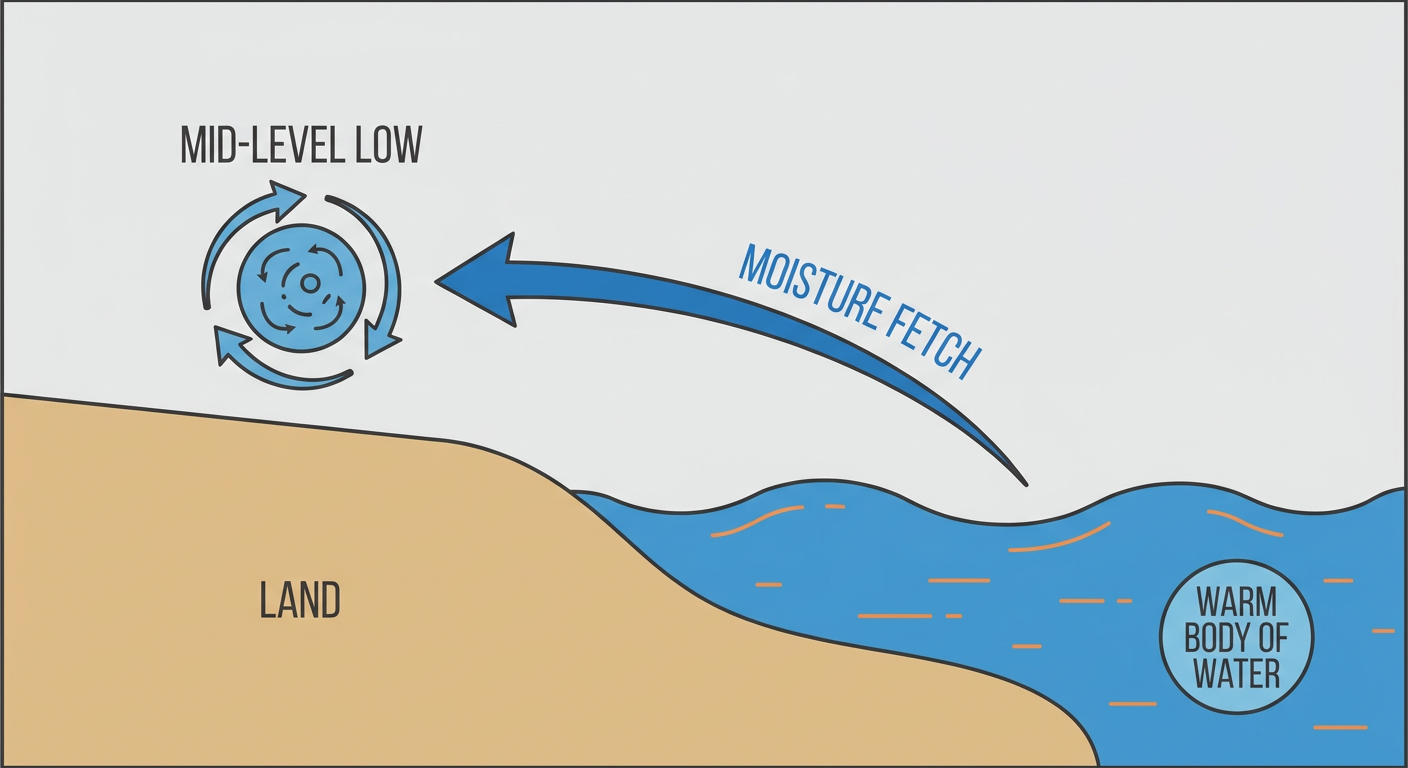
The Atmospheric Water Pump Continues
We have a slow-moving low-pressure system sitting in the mid-levels of the atmosphere right near the ArkLaTex region. It is acting like a giant water pump. It is pulling a continuous river of anomalous moisture straight out of the Gulf of Mexico and slinging it across the Deep South.
The Weather Prediction Center has a Slight Risk for Excessive Rainfall posted today from the Central Gulf Coast up into North Georgia and the Upper Ohio Valley. They have another Slight Risk posted for Monday covering the Gulf Coast toward the Southern Appalachians.
Here is the main issue. The ground in these areas is already completely saturated from yesterday's storms. Normal high temperatures for places like New Orleans and Atlanta sit in the low to mid 80s this time of year. We have plenty of warm air holding a massive amount of water. When you get these training thunderstorms moving over the exact same waterlogged soils, flash flooding happens fast. Expect to see 1 to 3 inches of rain in these zones, with locally higher amounts where the heaviest cells set up.
Severe Storms and West Texas Hail
We also have a few severe weather setups to track. Today, the Storm Prediction Center has a Marginal Risk covering parts of the Southeast and the Central Great Plains. This is a low-end threat. If a storm gets robust, it could produce 60 mph wind gusts or quarter-size hail. The tornado threat is very isolated at just 2 percent.
The bigger severe threat shows up on Tuesday after the holiday. An upper-level low is going to dig into the Pacific Northwest, and the subtropical jet stream will increase over Mexico. This is going to set the stage for organized severe storms in West Texas.
The SPC already has a Day 3 Slight Risk posted for places like Midland, Odessa, and Del Rio. The main hazards on Tuesday afternoon will be large to very large hail, severe wind gusts, and potentially a tornado or two. If you live in the Permian Basin, Tuesday is your day to be weather-aware.
Critical Fire Weather Out West
While the South deals with too much water, the Great Basin is dealing with the exact opposite. A potent trough moving into the Pacific Northwest is going to crank up the winds across the interior West on Monday.
The SPC has highlighted a Critical Fire Weather area for northwestern Nevada into southeastern Oregon for Memorial Day. We are looking at sustained winds of 20 to 25 mph combined with relative humidity dropping to between 10 and 15 percent. Any spark in those dry fuels will spread rapidly.
The Good News
It is not all bad news this weekend. High pressure is promoting clear skies and comfortable warmth right across the Midwest and the Pacific Northwest. If you are traveling the I-80 corridor or heading to the race track in Indiana today, you are going to find perfect conditions.
- Southeast Flooding: A Slight Risk for excessive rainfall continues today and Monday from the Gulf Coast to the Appalachians.
- West Texas Severe: A Slight Risk for severe storms is posted for Tuesday, with very large hail possible around Midland and Odessa.
- Nevada Fire Weather: Critical fire conditions are expected Monday in northwestern Nevada due to high winds and low humidity.
- Holiday Travel: Smooth flying and driving across the Midwest and West Coast. Expect delays at major hubs like Atlanta and Charlotte due to rain and low visibility.
Bottom Line
If you are in the South or the Ohio Valley this weekend, do not let a flooded road ruin your holiday. Turn around and find another route. For folks in West Texas, use the quiet holiday weekend to make sure your severe weather plan is ready for Tuesday afternoon. Have multiple ways to get warnings, and keep your phones charged.
https://ryanhallyall.com/blog/the-souths-stubborn-flood-threat-and-a-memorial-day-weather-split