Blog Article
Upper Midwest Severe Storms Today: 80 MPH Wind Threat
An Enhanced Risk for severe storms hits the Upper Midwest and Great Lakes today with 80 mph winds, large hail, and flash flooding as the heat wave builds east.

The Storm Machine Keeps Cranking: Upper Midwest Back in the Bullseye Today
Alright y'all, remember that storm machine we've been talking about? The one that will not quit over the Upper Midwest? It's still running, and today it's got a fresh Enhanced Risk stamped on it from the Storm Prediction Center. Same part of the country that got worked over the past two days is right back under the gun.
Here's the setup. Broad southwesterly flow aloft keeps pumping an unstable, muggy airmass northward into the Upper Midwest and Great Lakes. Add some shortwaves rolling through that flow, and you've got the ingredients for scattered severe storms this afternoon and tonight. SPC has the Enhanced Risk covering about 77,000 square miles and roughly 5.5 million people, including Green Bay, Traverse City, and a good chunk of northern Lower Michigan.
Where the threat sits and what to expect
The Enhanced Risk is the headline. Around it sits a broader Slight Risk that pulls in Minneapolis, plus a separate Slight zone out into the Northeast around Rochester, Syracuse, and Albany. Then a big Marginal Risk stretches all the way from New York City down to New Orleans and out to Omaha. That's a lot of real estate, but not everybody in it sees the worst.
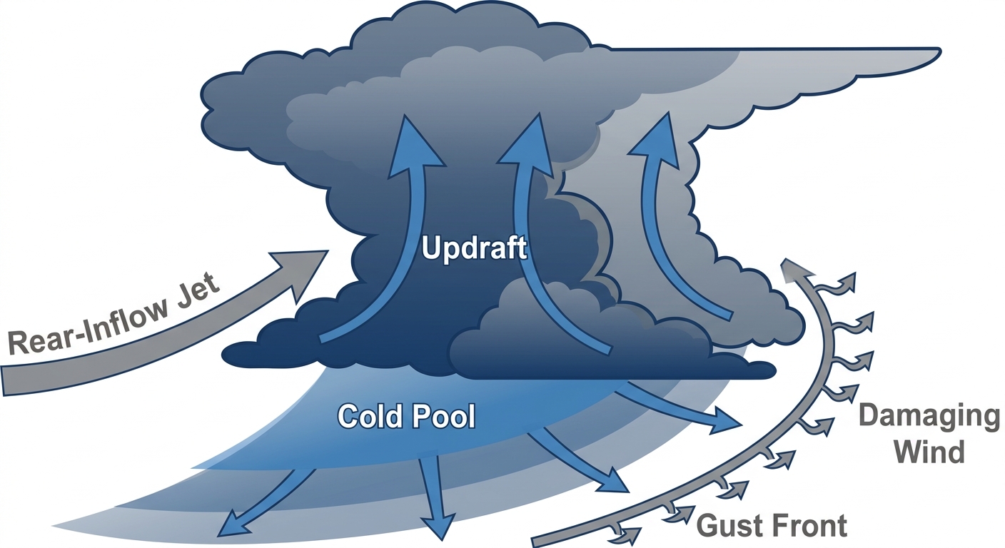
The main concern today is damaging wind. SPC is talking gusts up to 80 mph inside that Enhanced Risk zone. Here's why: late June and early July, storms in this part of the country love to grow upscale into damaging-wind complexes. That's the classic history here. Not tornadoes first, but a line or cluster of storms that organizes and pushes a wall of wind out ahead of it.
That said, don't sleep on the other hazards:
- Damaging wind: The big one. A Level 3 of 5 wind threat inside the Enhanced Risk, with gusts to 80 mph possible. Isolated to scattered wind damage across a much larger area.
- Large hail: A hatched zone means stones could reach 2 inches, hen-egg size. That'll dent cars and shred gardens.
- A few tornadoes: A Level 2 of 5 tornado threat over parts of the region. Not the top story, but if a storm stays discrete before things line out, an isolated tornado is on the table.
The rain piles onto ground that's already soaked
There's a second layer to this. WPC has a Slight Risk for excessive rainfall over the Upper Midwest today, and it carries right into Thursday and Friday. Precipitable water values are running well above normal, which is a fancy way of saying the atmosphere is loaded with moisture. When storms train over the same area, that's your flash flood setup.
The reason this matters more than usual: the ground up there has already taken repeated hits. We've watched flash flooding in Michigan earlier this week and wind damage stacking up night after night. Saturated soil and stressed trees don't handle another round well. It doesn't take much to bring down a limb that's already been loosened.
Meanwhile, the heat keeps marching east
We walked through the heat wave in detail yesterday, so I won't rehash the whole thing. But the short version hasn't changed: the heat is peaking Thursday and Friday, with highs in the 90s to low 100s and heat indices climbing past 105 in spots. The news headlines are all over it, and they should be. This is the story dominating the eastern half of the country heading into the holiday weekend.
If you're in the Northeast or Mid-Atlantic, the heat is your main concern, not storms. If you're in the Upper Midwest, you're juggling both.
What today's storms mean for your plans
Plenty going on outdoors. Summerfest Weekend 3 kicks off in Milwaukee tomorrow, and Milwaukee sits in that Marginal Risk today with the Slight zone not far north. Keep an eye on the sky if you're heading out. The Cincinnati Reds at Milwaukee Brewers game is under a roof, so that one's fine.
Out at the ballparks in the open air, the San Diego Padres at Chicago Cubs game at Wrigley and the White Sox game up in Baltimore are worth a radar check for afternoon and evening storms. Chicago's in the Marginal Risk today.
Here's your watch list for today:
- Timing: Afternoon into the overnight hours. Storms may grow upscale and travel a long way after dark, so this is not just a daytime threat.
- Wind is the top hazard: 80 mph gusts inside the Enhanced Risk. Secure loose outdoor items.
- Flash flood potential: Especially over ground that's already saturated in the Upper Midwest.
- Have a way to get warnings: If you're camping, at an outdoor event, or out at a game, make sure your phone alerts are on.
Bottom line
If you're in the Enhanced Risk across northern Wisconsin and northern Lower Michigan, today is a have-your-plan-ready kind of day. Damaging wind to 80 mph is the main threat, with large hail and an isolated tornado also possible, and storms could roll through well after dark. Folks in the broader Slight and Marginal zones should stay weather-aware and check the radar before evening plans. And if you're farther east under the building heat, hydrate, find shade, and pace yourself. Two different stories, one busy stretch of weather, and we'll keep tracking both.