Blog Article
Enhanced Severe Weather Risk: Texas Dryline to Oklahoma
A multi-day severe weather outbreak is targeting the Central and Southern Plains this week, while the Northeast prepares for more freezing rain and ice.
The Texas Dryline Awakens and Friday's Enhanced Severe Threat
Alright folks, welcome back. Yesterday we talked about the Blood Moon and those fancy new SPC intensity maps. Well, today we are seeing exactly why those maps matter. The severe weather engine is officially revving up, and we have a multi-day threat across the Plains that you need to know about.
Plus, if you live in the Northeast, you might want to keep the ice scraper handy. Let's dive right into the details.
The Texas Dryline Wakes Up on Thursday
Here's the thing about spring in the South. You can have jacket mornings, but you will absolutely keep the AC running by the afternoon. That rapid heating is exactly what is going to fuel our severe weather threat on Thursday.
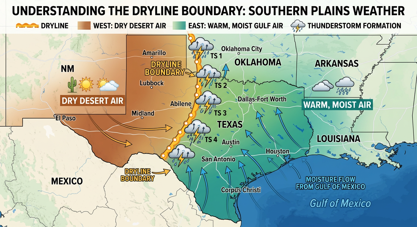
We have a Slight Risk of severe weather for West Texas up into south-central Kansas. Cities like Lubbock, Amarillo, and Dodge City are right in the bullseye. An upper-level system is kicking out of the Rockies, and it is going to form a sharp dryline across West Texas.
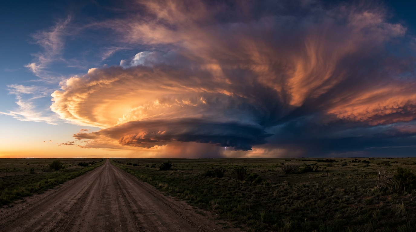
What is a dryline? It is a boundary separating very dry desert air from rich, moist Gulf air. When those two air masses crash into each other in the late afternoon heat, storms explode. We are expecting supercells to develop right on the Caprock by late Thursday afternoon.
Get this. The main threats tomorrow are going to be very large hail and severe wind gusts. But the Storm Prediction Center has also highlighted a 5% tornado risk for the Texas Panhandle area around Lubbock and Amarillo. If you live in these areas, you need to be weather aware as you head home from work or school.
Friday's Enhanced Risk
As we roll into Friday, this system pushes east and gets a lot stronger. The Storm Prediction Center has already issued an Enhanced Risk for parts of the Southern and Central Plains, stretching right up into the lower Missouri Valley.
This includes millions of people in places like Oklahoma City, Kansas City, and Tulsa.
- The Setup: A strong cold front will sweep southeast across the Plains. Ahead of the front, the air will be loaded with moisture.
- The Threats: We are looking at a serious risk for large hail, damaging straight-line winds, and tornadoes.
- The Timing: Storms will likely fire up by midday Friday and continue into the overnight hours as they sweep across the Ozarks and into the Mississippi Valley.
Fire in the West, Ice in the East
While the Plains are dealing with thunderstorms, we have two completely different extremes happening on the edges of this system.
Out West, it is bone dry. We have critical fire weather conditions expected today for eastern New Mexico and the Palmer Divide in Colorado. With wind gusts hitting 30 mph and humidity dropping below 15%, any spark could start a rapidly spreading wildfire.
Meanwhile, the Northeast is bracing for a wintry mess. A potent cold front is dropping down from Canada, and it is going to set up a classic freezing rain event.
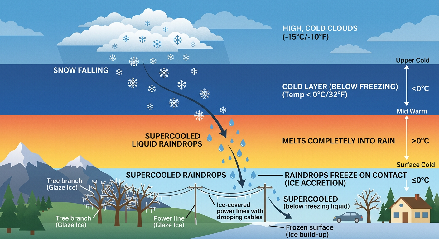
Starting Thursday evening and lasting through Friday, the southern Green Mountains, the Berkshires, and parts of southern New Hampshire are looking at moderate icing. WFO Albany is warning about ice accumulations up to a quarter of an inch. I know a lot of y'all are already searching online for WMUR school closings up in New Hampshire. With this much ice, you might just see some delays or cancellations Friday morning, so definitely plan for a messy, slippery commute.
What This Means For Your Weekend
The severe threat doesn't just vanish on Friday night. It is going to shift further east and south for the weekend. The SPC is already highlighting a 15% severe risk for next week, but even this Saturday, we are watching a cold front drop into the Ohio Valley and Texas.
If you are heading out to the massive Holi Festival in Pflugerville, Texas on Saturday, or if you have outdoor sports lined up, you will want to keep a very close eye on the radar. The weather is going to be incredibly active.
The Bottom Line
- Texas to Kansas: Have a way to get warnings Thursday afternoon and evening. Large hail is a near certainty with any storms that form on the dryline.
- Oklahoma to Missouri: Friday is your big day. An Enhanced Risk means widespread severe storms are expected. Review your tornado safety plan now.
- New England: Prepare for slippery travel and localized power outages Thursday night into Friday due to freezing rain.
- New Mexico & Colorado: Obey all burn bans. The fire danger is extreme.
I will be keeping a close eye on the data as it rolls in. Stay safe, be prepared, and keep looking up y'all.
https://ryanhallyall.com/blog/the-texas-dryline-awakens-and-fridays-enhanced-severe-threat