Blog Article
World Cup Final Weather: Jersey's Flood Pattern Explained
The World Cup Final hits New Jersey July 19, and the same flood-prone summer pattern just soaked NYC and NJ. Here's the meteorology behind it and what it means.

The World Cup Final Is Coming to Jersey, and the Weather Pattern That Just Flooded It Isn't Going Anywhere Yet
Alright folks, here's what the whole world is talking about right now. Ronaldo says this is his last World Cup. The search numbers back it up, tens of thousands of people looking up his age, his record, whether he's ever actually lifted the trophy. And the biggest match of all, the final itself, is headed to East Rutherford, New Jersey on July 19.
Now get this. That same corner of the country, New Jersey and New York City, spent today under a Moderate Risk for excessive rainfall from the Weather Prediction Center. That's a Level 3 out of 4. The local headline said it plain: "NYC and New Jersey Brace for Heavy Rain and Flooding." So before we all pile into a stadium in Jersey in less than two weeks, let's talk about the kind of summer setup that's been parking over the Northeast, because it tells you a lot about what a soccer final might be up against.
Why Today Got A Rare Moderate Risk
The WPC forecaster this morning actually flagged how unusual it was. Their own words: it's "unusual to have a MDT risk in an area with such low current and forecast instability." Translation, the atmosphere wasn't loaded with the usual thunderstorm fuel, and they still went with a high-end flood risk anyway.
Here's why. Flash flooding isn't really about how violent the storms are. It's about how much water falls and how fast, over ground that can't drink it in quick enough. The setup today had a stationary front draped across the Mid-Atlantic and precipitable water values over 2 inches. That's a fancy way of saying the whole column of air was a wrung-out sponge waiting to drop its load.
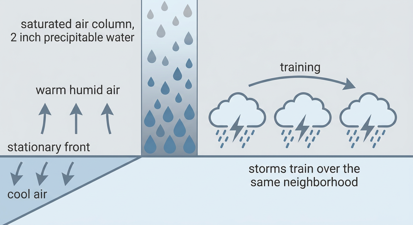
When storms line up and cross the same neighborhood one after another, we call that training, like railcars passing over the same stretch of track. You don't need a monster storm. You just need the same modest storm to hit your street five times in an hour. That's how you end up with the kind of scene Pennsylvania lived through just yesterday, where Hummelstown reported close to 4 inches of rain in 45 minutes and crews were pulling folks out of submerged vehicles.
This Has Been The Story All Week
This isn't a one-off. The Northeast and Mid-Atlantic have been stuck in a wet, stormy regime for days. Yesterday it was catastrophic flash flooding in Pennsylvania. Earlier in the week, Central Iowa measured over 13 inches of rain in 24 hours near Polk City. Same theme, different zip code: slow-moving storms, saturated ground, water with nowhere to go.
And the severe side has been busy too. We logged a 92 mph gust in Norman, Oklahoma yesterday. A 131 mph gust near Highmore, South Dakota back on June 29. The pattern this summer has been active, wet, and persistent.
So What About July 19?
Let me be straight with you, because accuracy matters more than drama. We cannot forecast the weather for the World Cup Final yet. Nobody can. That's almost two weeks out, well past the range of any honest daily forecast.
What I can tell you is this. New Jersey in mid-July normally runs warm and humid, with New York City averaging a high around 85 and a low near 68 this time of year. Summer in that corridor means afternoon and evening thunderstorm chances are a regular guest, not a rare surprise. The recent pattern has favored slow, soaking storm systems rather than quick-hitting ones. If that flavor of pattern is still around on the 19th, the concern for an outdoor event isn't wind or hail. It's a downpour that dumps a lot of rain fast and snarls the roads and rails getting 80,000 people in and out.
That's the practical piece. Getting to and from a packed stadium is where summer storms bite hardest, and today's flood headlines are a preview of the kind of transportation mess heavy rain can cause in that region.
The Nearer Stuff You Can Actually Plan Around
Before the final, the calendar is stacked. The MLB All-Star Game hits Philadelphia on July 14. And this week, Phillies and Nationals and Braves are all playing outdoor ballgames across the affected zone.
Here's the good news for the next couple days. The Storm Prediction Center has the Northeast drying out. The severe weather focus shifts to the Northern Plains for Tuesday, with a Slight Risk from the Dakotas into Minnesota, including Minneapolis. There's still a lingering flash flood risk from southwest Pennsylvania into central Virginia and northeast North Carolina on Tuesday, so folks in that stretch shouldn't file the umbrella away just yet. But the worst of the Northeast soaking is easing.
If you're heading to a ballgame this week in the Mid-Atlantic, keep half an eye on the radar for pop-up evening storms. That's normal July business. Nothing on the SPC boards suggests a widespread severe outbreak in the big Eastern metros over the next couple days.
The Takeaway
Ronaldo's last World Cup gets its final in a state that just spent a day underwater warnings. The lesson isn't panic, it's pattern. Summer flooding in the Northeast comes from slow, moisture-rich storms training over saturated ground, and that setup has been the season's signature. We'll get a real forecast for July 19 when it's actually inside the window. Until then, the smart move for anyone with big outdoor plans in the corridor is simple: know that heavy rain is the region's summer specialty, and build a little flexibility into how you get there.