Blog Article
Midwest Flood Risk Sunday, Plains Severe Storms This Weekend
Moderate flood risk hits the Midwest Sunday while Kansas, Oklahoma, and Colorado face severe storm chances. Plus a tropics update on three watch areas.
Tropics Stay Busy, But Sunday's Midwest Flood Threat Is the Story to Watch
Alright y'all, good Saturday morning. Let's get you caught up on what's actually gonna affect your weekend, because there's a lot happening on the map right now and not all of it matters to folks reading this in the US.
The Tropics Are Busy, But Quiet for Us
We've got four invests being tracked between the Atlantic and Eastern Pacific right now, and three of them carry a HIGH development risk from the National Hurricane Center. Here's the rundown:
- AL99 sits several hundred miles southwest of the Azores. A tropical depression could form later today, but this system is expected to drift south and stay well out to sea. Not a US concern.
- EP99, south-southwest of Mexico, is disorganized right now but sitting in a favorable environment. NHC thinks a depression could form late this weekend or early next week as it moves northward off the southwestern Mexican coast. Worth watching if you've got interests along that coastline, but it's not aimed at the US.
- EP98, also in the Eastern Pacific, carries an 80% development chance through the week.
None of these are pointed at the continental US right now. We'll keep an eye on EP99 since anything that tracks north off Mexico can eventually matter for the southwest US monsoon pattern, but for today, the tropics are a "watch and wait" story, not an "act now" story.
The Bigger Deal at Home: Flooding Rain Targets the Midwest Sunday
Here's the thing. After the week we just had, with 3 to 5 inches of rain flooding out I-95 in Connecticut and stranding cars in Paterson, New Jersey on the 13th, and West Des Moines picking up nearly 8 inches back on the 9th, the flood-prone pattern hasn't really let up. It's just moving.
Today (Day 1), WPC has a Slight Risk of excessive rainfall posted for the Upper Mississippi Valley and southwest Montana. That's the appetizer.
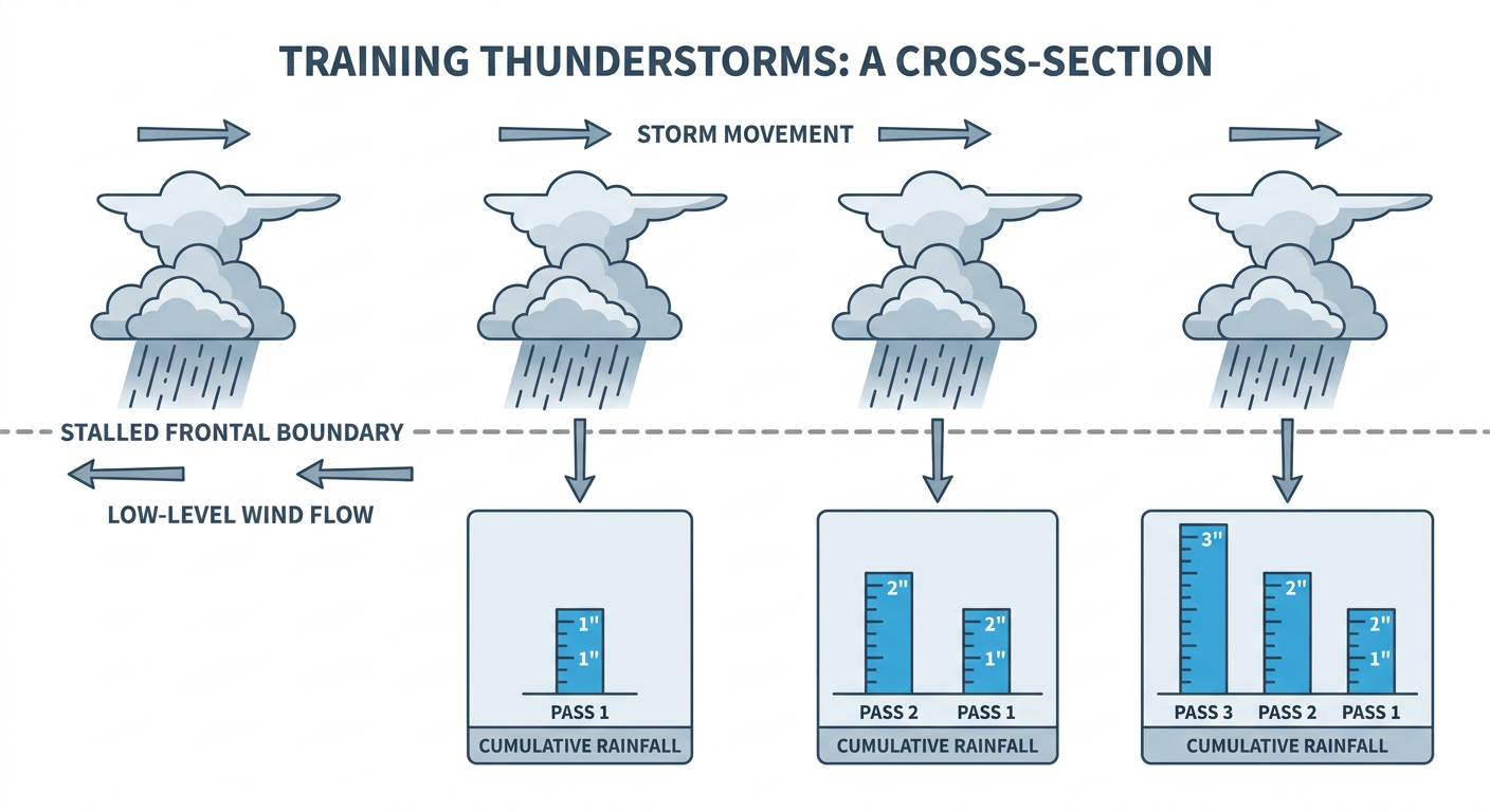
Sunday (Day 2) is the main course. WPC has bumped a chunk of the Midwest and Ohio Valley up into a Moderate Risk of excessive rainfall, and that's not a category WPC hands out lightly. The zone covers eastern Iowa, northern Illinois, southern Wisconsin, and northern Indiana, which means the Quad Cities, Chicago, Milwaukee, and Fort Wayne are all in the crosshairs. Multiple rounds of training thunderstorms (storms repeatedly moving over the same area, like cars on a train track) are the concern, and with precipitable water values running near or above the 99th percentile for this time of year, hourly rain rates of 2 inches or more are possible. That's enough to overwhelm storm drains fast, especially in urban areas like ORD and MDW where airport delays are already a good bet.
If you're in that Moderate Risk zone for Sunday, keep half an eye on the radar during the afternoon and evening. Flash flooding doesn't need a hurricane to cause real problems, and this setup has the ingredients for it.
Severe Storms: Kansas Today, Oklahoma and the Front Range Tomorrow
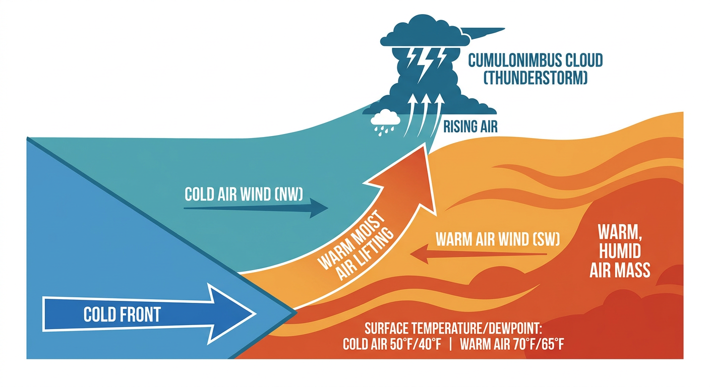
SPC has a Slight Risk of severe thunderstorms posted for today across parts of the central Plains, roughly Wichita and Topeka in Kansas over to Akron and Deer Trail, Colorado. A cold front is dropping south into the Plains today, and ahead of it, storms will fire this afternoon and evening capable of scattered severe wind gusts and hail around quarter size. There's also a broader Marginal Risk stretching from Denver and Kansas City over to Indianapolis, Louisville, and even Atlanta, mainly for isolated gusts.
Sunday, the action slides into central and eastern Oklahoma, plus the Colorado Front Range, both under a Slight Risk. This is the one Oklahoma State Fair goers in OKC need to know about. With temperatures likely climbing into the 90s (that's roughly 6 to 10 degrees above the September normal high of 84°F for Oklahoma City) and dewpoints near 70, there's enough instability building ahead of a southward-moving cold front to support MLCAPE values in the 2,500 to 3,500 J/kg range. That's plenty of fuel. Storms are expected to fire mid to late afternoon and could merge into clusters or an outflow-dominant cluster capable of damaging winds of 60 mph or better and hail around or above an inch. SPC also has a 2% isolated tornado probability tagged onto part of the southern Plains for Sunday, which isn't a headline number, but it's not zero either.
What Else Is Going On
- Nice weather elsewhere: If you want the best sky in the country today, head to northern New England, the interior Pacific Northwest, or Arizona's high country, where high pressure is delivering dry air and light wind. Sunday, that title shifts to the central Rockies and Intermountain West.
- Space weather: Nothing to worry about. A minor G1 geomagnetic storm passed through on the 16th and 17th, and conditions are quiet through Monday. Another small G1 chance shows up September 24 through 26 if you're an aurora chaser watching the northern sky.
- Day 3 severe: A Marginal Risk shows up Monday for the Tennessee Valley into the southern and central Appalachians, mainly isolated gusts. Nothing major yet, but we'll keep watching it.
- Fire weather: A surface low deepening over the central Plains today will bring breezy southwest winds, something to note if you're in north-central Texas or southern Oklahoma, though no critical fire weather has been flagged yet.
Bottom Line
The tropics are noisy right now with three separate HIGH-risk development areas, but none of them are knocking on the US mainland's door today. Save your worry for closer to home. If you're anywhere from eastern Iowa through Chicago, Milwaukee, or northern Indiana, Sunday's Moderate excessive rainfall risk deserves real attention, this is a flash flood setup, not just a rainy day. And if you're in Oklahoma or along the Colorado Front Range, especially if you're headed to the Oklahoma State Fair in OKC, keep tabs on the sky Sunday afternoon. Storms capable of damaging wind and hail are a real possibility as that cold front works through. Everybody else from the Rockies to the Pacific Northwest, enjoy what's shaping up to be a genuinely nice weekend.