Blog Article
Nolo, Polo & Southwest Flood Risk: Sept 28 Forecast
Hurricane Nolo nears Cat 5 near Hawaii, Hurricane Polo hits Baja tonight, and a Moderate flood risk spreads from the Four Corners into the southern Plains.

Two Majors, One Moderate Flood Risk, and a Wednesday to Watch in the Southern Plains
Alright y'all, Monday morning and the tropics are stacked three deep in the Eastern Pacific. We've got two hurricanes, a tropical storm, and a disturbance NHC is giving a 90% shot at development by day seven. That's a lot to track, and the moisture off two of those systems is about to cause real problems on dry land, not just at sea. Let's get into it.
Hurricane Nolo: Category 4 and Knocking on Category 5's Door
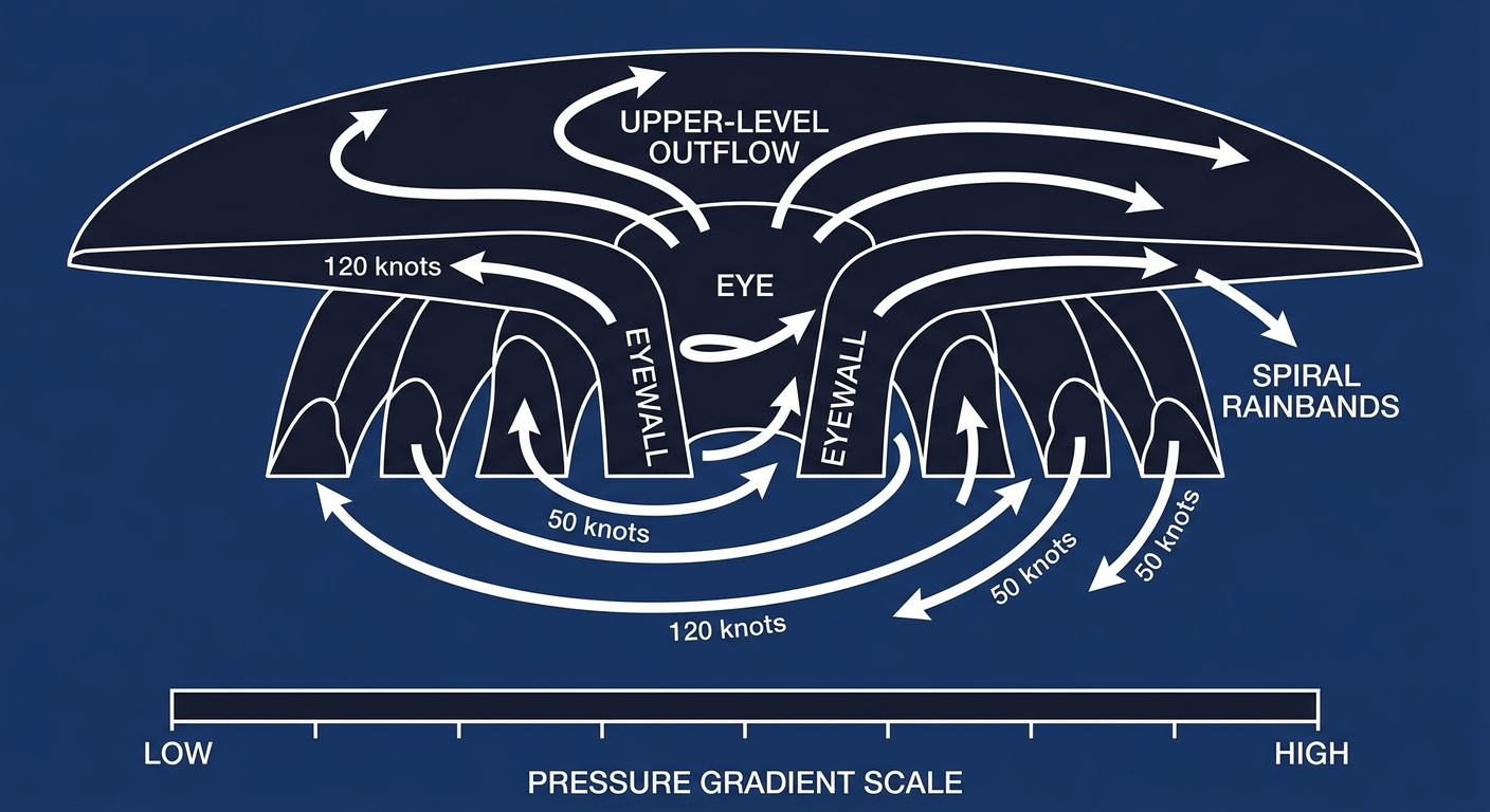
Nolo is the strongest thing on the map right now. As of the overnight advisory, sustained winds sit at 155 mph with a central pressure of 929 mb, and NHC's discussion says the system could soon reach Category 5 intensity. That's a well-organized, symmetrical hurricane with a 30 nautical mile eye and cloud tops cold enough to mean serious business.
Here's the good news for Hawaii: Nolo is still several hundred miles southwest of the islands and forecast to stay well offshore. The closest approach to Kauai's south shore is projected around 279 miles out, roughly two days from now, with intensity weakening to around 102 mph by the time it gets that close. Our impact model has Hawaii sitting at a "prepare" threat level, not an "action" level. Translation: this is a get-your-plan-ready storm for surf, swells, and rip currents, not a bunker-down hurricane threat for the main islands right now. The Central Pacific Hurricane Center is watching Papahanaumokuakea closely given the track uncertainty this far out, so don't tune this one out just because it's staying offshore for now.
Hurricane Polo: Category 3, and Baja California Sur Is In the Bullseye
While Nolo grabs headlines for its intensity, Polo is the one with an actual landfall clock running. This Category 3 hurricane, 115 mph winds and a 958 mb pressure, is about 125 miles southwest of Cabo San Lazaro and moving north-northeast at 10 mph. NHC's forecast has Polo making landfall near Loreto in roughly 16 hours, so sometime tonight into early Tuesday.
Our impact model has bumped Loreto and Santa Rosalía to the "action" threat tier, meaning life-threatening winds and flash flooding are expected today and Tuesday across Baja California Sur and into Sonora. Hermosillo and Guaymas sit one notch down at "prepare." If you've got family or business ties across the border in that stretch of Mexico, today's the day to finish preparations, not start them.
Rachel, Fay, and a Disturbance Worth Watching
Tropical Storm Rachel is running 46 mph winds a few hundred miles southwest of Acapulco and tracking west-northwest, mostly a coastal Mexico concern over the next several days rather than a US one. Way off in the central Atlantic, Tropical Depression Fay remains a weak, disorganized system with no coastal watches or warnings.
The one to actually keep an eye on longer-term is an unnamed disturbance well east-southeast of Hawaii that NHC gives a 70% shot at development within two days and 90% within seven. That's a high-confidence call this far out, so expect a name attached to that system before the week is out.
The Flood Threat Back Home: Moderate Risk From the Four Corners Toward the Plains
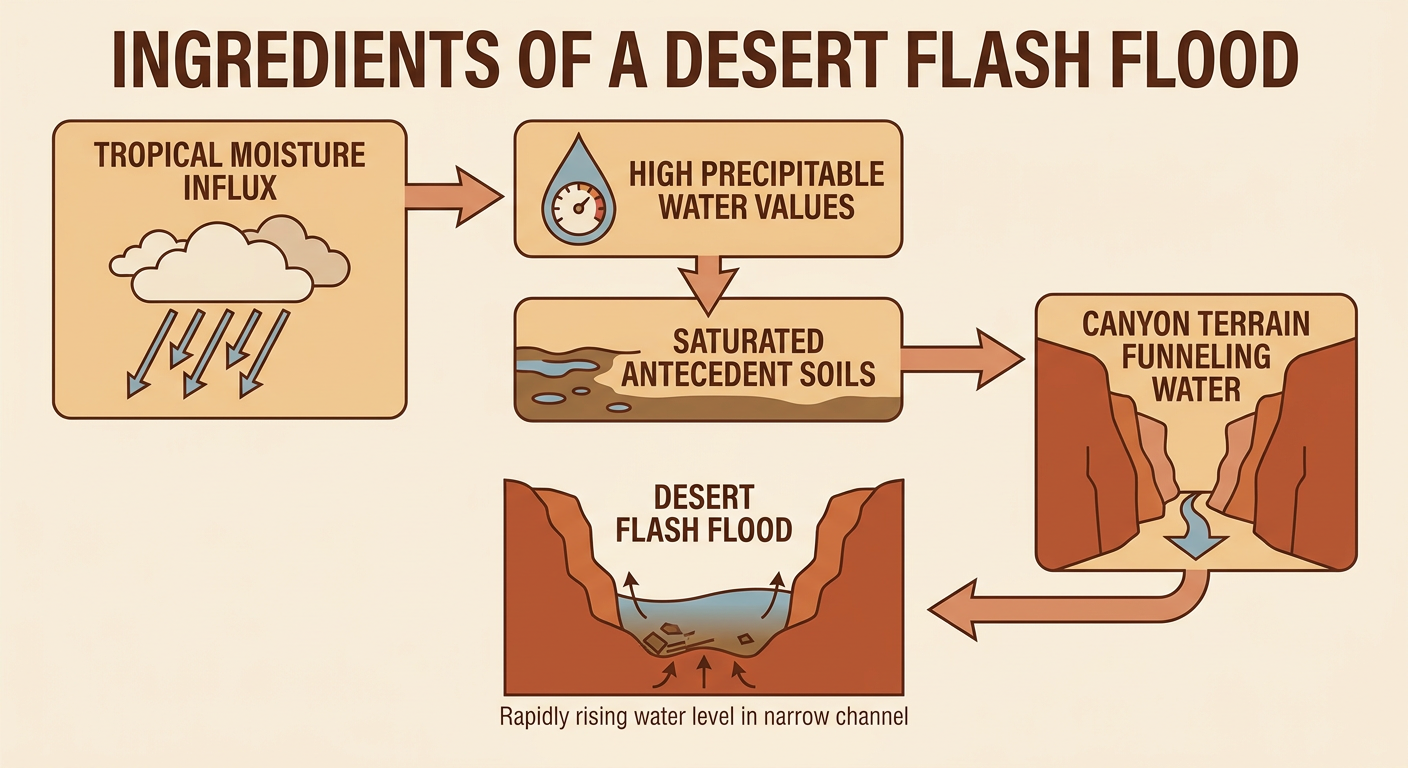
Here's where the tropics stop being a Pacific story and become a US story. WPC has a Moderate Risk of excessive rainfall posted today across the Southwest and Four Corners, and it's directly tied to a predecessor rainfall event fed by leftover moisture from Odalys combined with Polo's approach. Precipitable water values are running 2 to 3.5 standard deviations above normal for this time of year, and soils across the region are already at or near saturation from recent heavy rain. That's a recipe for widespread 1 to 3 inch totals with considerably higher amounts possible in favored spots.
The risk doesn't sit still. By Tuesday, the Moderate Risk zone spreads from the Southwest into the southern High Plains as remnant upper-level energy from Polo lifts out. By Wednesday, WPC has Moderate Risk categories painted across the central and southern High Plains and into the southern Plains, with the tropically enhanced moisture axis stretching all the way toward the northern Mississippi Valley.
Our forecast team has specifically flagged Phoenix and Flagstaff, Arizona; Albuquerque, New Mexico; and Salt Lake City, Utah, for this stretch, all places dealing with the same core issue: burn scars, slot canyons, arroyos, and urban drainage that just can't handle water moving that fast. For reference, Phoenix normally sits around 100°F for an afternoon high this time of year and Salt Lake City around 81°F, so if you see cooler, cloudier days behind this rain, that's the tropical moisture and cloud cover doing their thing, not an early cold snap.
If you're eyeing the Albuquerque International Balloon Fiesta starting October 3, this system should be clearing the immediate area by then based on the current three-day outlook, but saturated soils and swollen arroyos from this week's rain could still be a lingering headache for the grounds crew.
Wednesday's Severe Weather Risk in the Southern Plains
The same upper-level system driving all that rain eastward is also going to fire up some severe storms. SPC's Day 3 outlook has a Slight Risk posted for Wednesday afternoon and evening across west-central and northwest Texas into western and central Oklahoma, covering Abilene, Wichita Falls, San Angelo, Lawton, and Altus. A Marginal Risk wraps around that core into Oklahoma City, Wichita, Enid, and Stillwater.
The setup: a 50 to 70 knot upper-level low digs into the region, and large hail, damaging wind gusts, and an isolated tornado or two are all on the table. For context, OKC and Tulsa both run a normal high of 84°F in late September, so this isn't a heat-driven setup, it's a dynamics-driven one riding in ahead of that same trough responsible for the flood threat. Looking further out, SPC's extended discussion has Thursday's instability axis stretching from central Texas into southwest Missouri, so this pattern isn't a one-day deal.
Meanwhile, Some Genuinely Nice Fall Weather
It's not all warnings and watch items. Today's best weather sits in a run from the Ohio Valley into the Carolinas and Southeast, plus pockets of the Ozarks, Upper Michigan, and the interior Willamette Valley, where light wind, dry air, and mostly clear skies add up to a near-ideal early-fall day. That same general corridor, Ohio Valley through the Carolinas, holds up nicely into Tuesday and Wednesday too, with the central High Plains and interior West joining the party by midweek. If you're headed to the Chicago Bears and Eagles game today or catching any of the fall festival circuit in the Southeast, you picked a good week for it.
Fire Weather Watch: Southern California
Surface high pressure building into the Intermountain West combined with an upper low dropping into the Lower Colorado River Basin is setting up dry, offshore wind flow across southern California today and Tuesday. Expect gusts of 30 to 45 mph in wind-prone terrain across southern Santa Barbara County and the mountains and foothills of Ventura and LA counties, paired with relative humidity down in the 15 to 25 percent range. That combination is enough to support elevated fire weather concern, so if you're in those foothill communities, it's worth double-checking your defensible space this week.
Space Weather: Quiet, For Now
SWPC has the geomagnetic field running mostly quiet through Wednesday, with just a slight chance of an M-class solar flare today. Nothing here threatens power grids or GPS in the near term. Worth flagging for the calendar: SWPC's 27-day outlook shows a G1 (Minor) geomagnetic storm possible around October 22, so mark that one for later, not this week.
What We're Watching
- Whether Nolo actually reaches Category 5 strength, and whether its track shifts any closer to the main Hawaiian Islands
- Polo's landfall near Loreto tonight into Tuesday, and how quickly it weakens once it interacts with Baja's terrain
- The Moderate Risk flood zone sliding from the Four Corners into the southern High Plains through midweek, especially in burn scar and slot canyon terrain
- Wednesday's Slight Risk severe setup in west Texas and Oklahoma, and how far east the Thursday instability axis pushes
- That East Pacific disturbance NHC gives a 90% shot at becoming a named system within a week
Bottom Line
Hawaii should keep an eye on Nolo's swells and surf but doesn't need to panic about a direct hit right now. Baja California Sur and Sonora need to be in full preparation mode today as Polo comes ashore near Loreto tonight. And here in the US, the real ground-level story is the Moderate Risk flood threat sliding out of the Southwest into the southern Plains through Wednesday, layered right on top of a legitimate severe weather setup in west Texas and Oklahoma. If you're in Arizona, New Mexico, Utah, or the Texas Panhandle this week, know your flash flood evacuation routes and stay off flooded roads. If you're in the Abilene-to-Lawton corridor Wednesday, have a way to get warnings after dark.