Blog Article
Valentine's Day Weather: South Severe Storms & Sierra Snow
Severe storms threaten Valentine's Day plans in the South while the Sierra Nevada braces for up to 8 feet of snow. Get the full forecast here.

Valentine's Day Outlook: Severe Storms Crash Date Night in the South & 8 Feet of Snow for California
Alright folks, Happy Valentine's Day! I hope y'all got your chocolates and flowers ready. But here is the thing. Mother Nature didn't get the memo about this being a peaceful holiday. We are tracking a very active setup that could put a damper on your date night plans, especially if you are down in the South.
Yesterday we talked about how the pattern was flipping, and now we are seeing it happen in real time. We have a split-screen situation today. One half of the country is dealing with a severe weather threat that could spin up tornadoes, and the other half is getting buried under enough snow to hide a two-story house. Let's break it down.
Heartbreak Weather: Severe Storms in the South
If you are in East Texas, Louisiana, or Mississippi, keep your phone on loud during dinner tonight. The Storm Prediction Center has outlined a Slight Risk (Level 2 out of 5) for severe weather today.
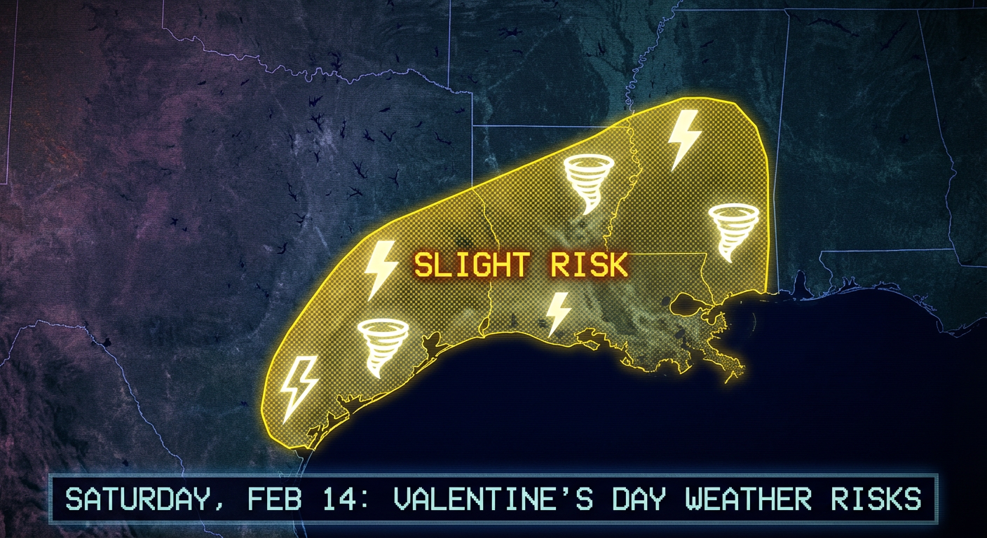
Here is the deal. A low-pressure system is moving through, and it is tapping into some warm, moist air from the Gulf. This is going to fire off showers and thunderstorms starting this afternoon and going into the overnight hours. The main threats are damaging winds and hail, but there is a 5% tornado risk in that yellow zone. That includes places like Houston, Baton Rouge, and New Orleans.
It doesn't stop there. As we head into Sunday (Feb 15), this energy shifts east. We are looking at a Slight Risk for Northern Florida and Southern Georgia. Folks in Tallahassee and Jacksonville, you need to pay attention tomorrow. The data is suggesting we could see a "strong tornado or two" with this setup on Sunday. If you are heading out to the 321: Food Fest in Melbourne or just traveling back home, keep an eye on the sky.
The Western Whiteout: "Donner Party" Levels of Snow
While the South is dodging lightning, the West Coast is getting hammered. We have been talking about this atmospheric river, and it is delivering. The Sierra Nevada mountains are in the bullseye of a major winter storm.
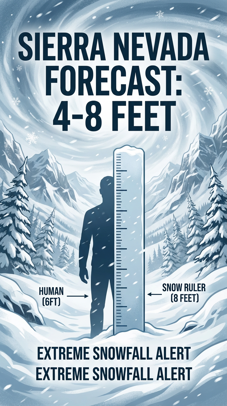
Get this. The Weather Prediction Center is forecasting 4 to 8 feet of snow for the higher elevations. That is not a typo. That is potentially life-threatening if you try to travel through the passes. Interstate 80 and the other mountain routes are going to be parking lots—or just completely closed.
This system is also bringing a Marginal Risk for severe weather to coastal Southern California by Monday. So places like Los Angeles could see some feisty storms to start the work week.
Space Weather: A Belated Valentine's Gift?
The sun has been incredibly active lately. We just had another CME (Coronal Mass Ejection) pop off, and it is heading our way. The Space Weather Prediction Center says we could see G1 to G2 geomagnetic storming by late Sunday into Monday.
What does that mean for you? Well, if you are in the northern tier states, you might get a belated Valentine's gift in the form of the Northern Lights. It is not a guarantee, but the potential is there.
The Bottom Line
Here is what you need to do:
- For the Date Night Crowd (TX, LA, MS): Have a way to get warnings tonight. If you are dining out, know where the safe place is. Don't drive through flooded roads—remember, we have a flood risk in the ArLaTex region too.
- For the Sunday Crew (FL, GA): The tornado risk tomorrow is real. Charge your devices tonight so you are ready for Sunday's storms.
- For the West Coast: Do not attempt to drive through the Sierra Nevada unless it is an absolute emergency. That much snow is no joke.
Stay safe, enjoy the candy, and keep watching the weather, y'all!