Blog Article
Vance, Olana Stay Offshore as US Weather Pattern Calms
Tropical Storms Vance and Olana stay away from the US mainland while the Lower 48 enjoys a calmer stretch, with mountain snow returning out west by late week.
Vance and Olana Stay Offshore While the Lower 48 Settles Into a Quiet Stretch
Alright y'all, good morning. After the week we just had, from San Juan River flooding in New Mexico to King Tides swamping the SC-61 off-ramp in Charleston, it is genuinely nice to open up this morning's data and see things calming down. Let's start where the attention is, which is the tropics, then work our way back home.
Vance and Olana: Two Storms, Neither One a US Threat
Tropical Storm Vance is sitting about 260 miles southwest of Manzanillo, Mexico, crawling northwest at just 6 mph with 65 mph winds and a pressure of 995 millibars. The National Hurricane Center's forecast discussion says Vance isn't well organized right now, with disorganized bursts of convection and outflow mostly limited to the northern side of the storm. The official track brings it closest to the Mexican mainland near Topolobampo late this week, and by then it's expected to be down to about 35 mph, basically a fading remnant low. There's no coastal watch or warning in effect, and nothing in the data points this storm toward the US.
Out in the Central Pacific, Tropical Storm Olana is a much smaller system, 40 mph winds, 1002 mb, moving east at 7 mph roughly 490 miles southwest of Johnston Island. Southwesterly shear is starting to work on it, and the forecast track keeps its closest pass to Hawaii (near Kauai's south shore) on Wednesday, still well offshore. There's also a new Invest, 94CP, trailing along near the Date Line with 30 kt winds, worth a glance but nothing urgent yet. If you've got flights through Honolulu over the next couple days, the airport travel data is already flagging some convective bumps there, so build in a little buffer.
Bottom line on the tropics: two named storms on the board, zero direct US impact expected from either one right now.
The Lower 48 Takes a Breather
After the severe weather and flash flooding that tore through New Mexico and Far West Texas yesterday, including a radar-indicated tornado warning in Quay County and warnings for up to 1.5 inch hail and 60 mph gusts, today looks a lot calmer there. SPC's extended discussion for Day 4 through 8 (Thursday through next Monday) describes a "low-amplitude and weak deep-layer flow regime" settling in over most of the country. That's meteorologist for not much going on. A weak shortwave trough is expected to eject across the southern Plains toward the Mid-Mississippi Valley by Friday, with just enough moisture for scattered showers and thunderstorms, nothing SPC is highlighting as a severe setup at this range.
The nicest weather today sets up across the southern Appalachians, the central Mid-Atlantic, central New York, and the desert Southwest, rated BEAUTIFUL in our nice weather outlook thanks to dry high pressure and ridging. If you're headed to Philadelphia for Eagles-Cowboys this afternoon, you picked a good day for it. Tomorrow that same beautiful air shifts toward the Georgia-Carolinas corridor and the Florida Panhandle, good news if you're making the drive down for the Breeders' Cup in Lexington later this week, since the trend through Wednesday looks dry and pleasant across that stretch too.
Rain Risk: Marginal, Not Major
WPC has a Marginal excessive rainfall risk, that's the lowest tier on their scale, posted for the central and southern High Plains today as an upper low and trailing cold front and dryline move across the central Plains. Scattered showers and storms are possible there, but this isn't a flash-flood-emergency kind of setup like we saw out of Dodge City earlier this month.
The other Marginal risk area is southeast Florida, where onshore flow is piling up moisture (precipitable water values near 2 inches) ahead of a weak upper low drifting north of the Bahamas. That risk holds through Tuesday and Wednesday, focused along the I-95 corridor from around Cape Canaveral down to Fort Lauderdale. Our airport travel data already flags FLL for potential IFR conditions and heavy downpours today, so if you're flying in or out of South Florida, check your flight status before you leave for the airport.
Mountain Snow Returns, Days 4 Through 7
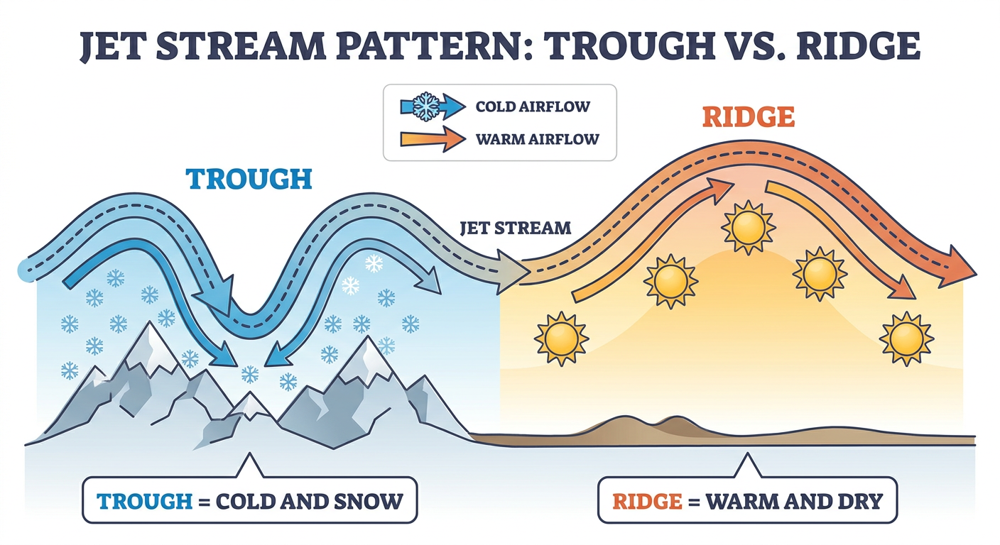
Here's the headline for the back half of the week. A persistent upper-level trough is going to dig into the western US and bring multiple rounds of accumulating mountain snow to the Pacific Northwest and the northern to central Rockies from Thursday through Sunday. Seattle and the Cascades are in that snow outlook zone, along with higher terrain further into the Rockies.
Meanwhile, downstream ridging is going to hold unseasonably warm and dry conditions over the central and eastern US through that same stretch, which is why winter weather stays locked out of the Plains, Midwest, and East for now. That's a pretty classic late-October split pattern, mountain snow out west, lingering warmth in the east, and it lines up with the "anomalous ridging" language in both the winter outlook and the nice weather discussion.
What We're Watching
- Vance's final days: expected to weaken to a remnant low well off mainland Mexico by late week, no US impact anticipated
- Olana's shear fight: increasing wind shear should keep it weak as it tracks east, staying well south of the main Hawaiian islands
- Southeast Florida rain: Marginal flood risk continues into Tuesday and Wednesday along the I-95 corridor, watch for ponding on urban streets
- High Plains showers: a weak dryline/front combo brings scattered storms today, isolated strong cells possible from New Mexico into southwest Kansas, but overall severe potential is low
- Pacific Northwest and Rockies snow: multiple rounds Thursday through Sunday, first real taste of accumulating mountain snow since the Montana storm earlier this month
- Minor geomagnetic storm: SWPC has a G1 (Minor) storm flagged for October 31, Kp of 5, worth a look after dark for folks at higher latitudes who like chasing aurora
Bottom Line
Nothing in today's data demands you change your plans. Vance and Olana are tropical storms to watch on a map, not systems to worry about stateside. If you've got outdoor plans in the Mid-Atlantic or Southeast the next couple days, today and tomorrow look genuinely nice. Keep an eye on ponding rain if you're in southeast Florida or the central High Plains, and if you've got mountain travel out west planned for the back half of the week, the Cascades and Rockies are about to see their next real shot of snow. Nothing urgent, just a good week to actually enjoy the forecast for once.