Blog Article
Vance's Moisture Could Spark TX Flood Risk Thursday
Tropical Storm Vance weakens off Mexico, but its moisture may fuel a Slight Risk of flash flooding in West Texas Thursday. Plus a first winter storm out west.

Vance Weakens Offshore Mexico, But Its Moisture Could Reload Texas Flood Risk by Thursday
Alright y'all, let's talk about what's actually worth watching this morning, because it's not really about today. It's about Thursday, and it's got a familiar address: West Texas and the Edwards Plateau, the same general stretch of country that just got hammered by flash flooding this week.
If you read our coverage the last couple days, you know El Paso County and Socorro County, New Mexico took it on the chin. Two tornado warnings, flooded apartments, stranded vehicles, and sadly one confirmed fatality near Bernardo when a vehicle was swept into floodwater. That ground is tired. The soil is saturated. And now there's a setup brewing that could bring another round of heavy rain to that same corridor.
The Setup: Vance's Leftovers Head for Texas
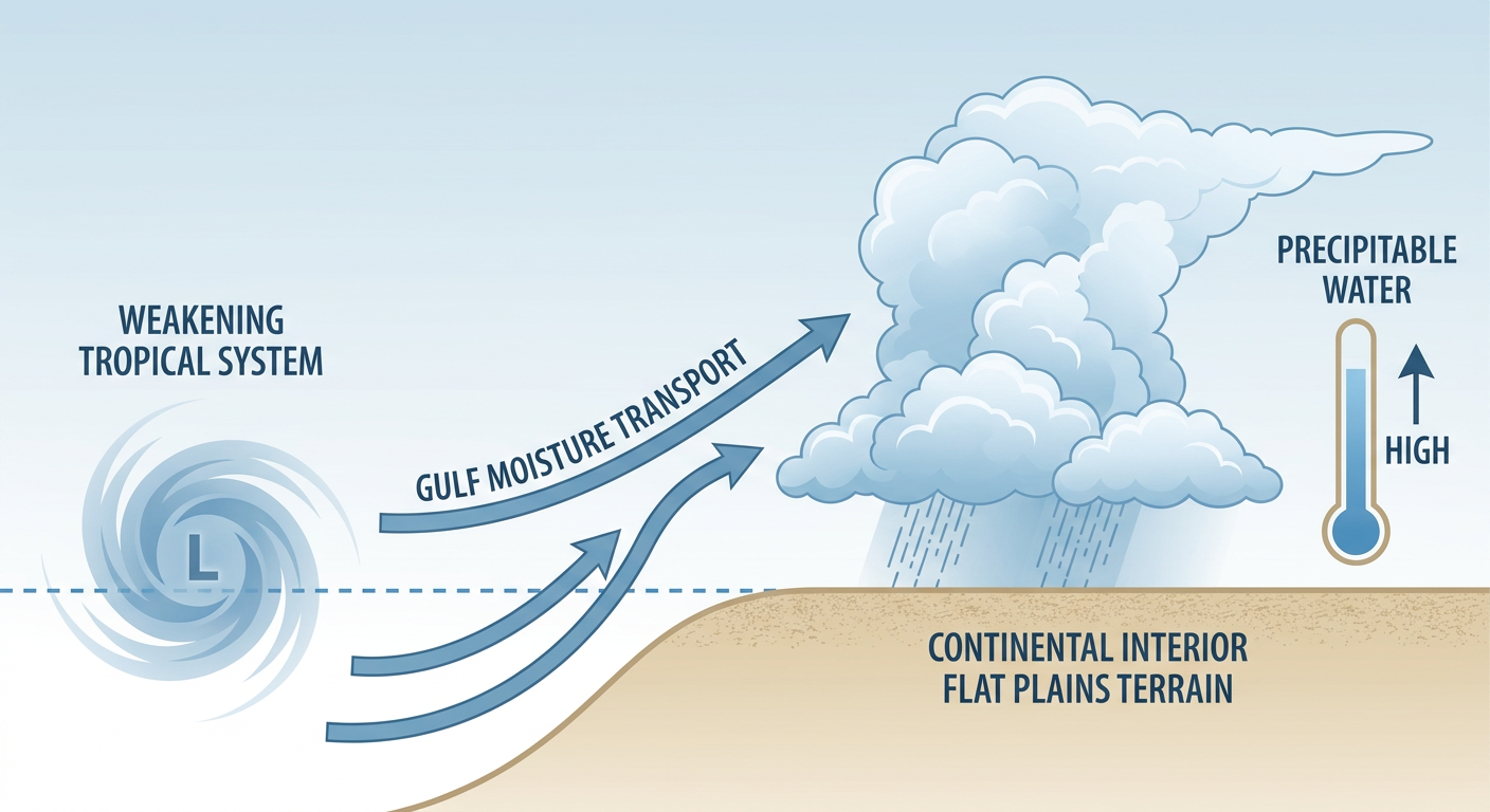
Tropical Storm Vance is out in the East Pacific, sitting about 275 miles southwest of Manzanillo, Mexico, with 45 mph winds and a central pressure of 1002 mb. Here's the thing about Vance though: it's falling apart. Satellite imagery shows the low-level center is now fully exposed, meaning the thunderstorm activity has gotten separated from the spinning part of the storm. That's a classic sign a tropical system is losing its structure. There's no coastal watch or warning in effect, and current forecasts don't show a US landfall. Its closest approach to land looks to be near Mazatlan on Thursday, and even then it's expected to be weak, maybe 35 mph winds at that point.
But weakening tropical systems don't just vanish. They dump their moisture into the atmosphere, and that moisture has to go somewhere. WPC's forecast discussion specifically calls out Vance's remnant energy lifting into Texas and New Mexico by Thursday, riding in on southeasterly flow that will drag anomalous Gulf moisture into the south-central US. Precipitable water values, basically a measure of how much moisture is stacked up in the atmospheric column, are expected to run well above normal for this.
The result is WPC's Day 3 outlook (valid Thursday into Friday) now carries a Slight Risk of excessive rainfall for portions of West and Central Texas, upgraded from the marginal risk categories we're seeing today and tomorrow.
Who needs to watch this
- The Permian Basin and Midland/Odessa area: right in the bullseye for Thursday's slight risk
- The Edwards Plateau and western Hill Country: terrain that funnels and concentrates runoff fast
- Southern New Mexico: already waterlogged from this week's flooding near Bernardo and the San Juan basin flooding earlier in October
- Far West Texas, including El Paso: recovering from this week's flash flooding and tornado warnings
None of this points to a repeat of the catastrophic river flooding we saw on the San Juan earlier this month, and it's not an SPC severe weather setup either. The AI synthesis on this pegs it as a heavy rain and localized flash flood concern, not a wind or hail threat. But when ground is already saturated, it doesn't take a historic rain event to cause real problems. A fast two or three inches in an hour can do plenty.
Meanwhile: Florida's Coastal Soak Continues
Southeast Florida carries a Marginal Risk of excessive rainfall today and Wednesday too. A lingering area of low pressure near the Bahamas is keeping northeasterly flow pumping moisture into the I-95 corridor, with PWATs up to 1.7 to 2 inches. Expect training coastal showers and storms capable of 1.5 to 2.5 inches per hour, right on top of a coastline that's still cleaning up from this week's King Tide flooding in Miami Beach, Fort Lauderdale, and Palm Beach. If you're along that stretch, don't be surprised by standing water on low-lying roads even without a dramatic-looking sky.
Olana Fizzles in the Central Pacific
Far out in the Central Pacific, Olana has officially been downgraded to a post-tropical cyclone. The National Hurricane Center issued its last advisory on this one. Winds are down to about 30 mph, the circulation is weak and elongated, and it's drifting south-southeast over open water more than a thousand miles from the nearest land. Nothing to track here, just closing the book on a storm we mentioned earlier this week.
Today's Forecast: One of Fall's Best-Looking Days
Here's the good news if you're not in the flood-watch zones. Today is shaping up to be genuinely beautiful across a wide stretch of the country. Southeastern Arizona, central and southern New Mexico, West Texas, and a broad swath of the Southeast, think central Georgia, the Carolinas, eastern Tennessee, and southwest Virginia, all get light winds, next-to-nothing rain chances, and mostly clear skies. The only thing keeping today from a perfect score nationally is air quality, with AQI readings running a bit elevated in spots, not temperature or rain.
Wednesday, the sweet spot shifts to the Mid-South and lower Mississippi Valley: central and southern Arkansas, western Tennessee, southeast Missouri, northeast Louisiana, and southern Illinois. That's classic late-October stuff for that part of the country, when afternoon highs normally sit in the low-to-mid 70s (Little Rock averages 74 this time of year). High pressure, dry air, and light wind make for a gorgeous jacket-morning, shirt-sleeve-afternoon kind of day.
Looking Ahead: First Real Taste of Mountain Winter
We've got a Days 4-7 winter storm outlook worth flagging for anyone out west. A broad upper-level trough digs into the Intermountain West and Rockies this weekend, bringing accumulating snow to higher terrain. By Day 6 (Saturday), that snow threat expands to include Salt Lake City and the Wasatch Front, population impact estimates running north of 4 million people in that outlook zone. By Day 7 (Sunday), the risk area shifts toward Denver and the Front Range. Remember, Denver's October average high is 66 and the average low is 35, so this would be an early reminder that ski season and winter driving season are both right around the corner for the high country.
Space Weather: Watch the Sky Halloween Night
NOAA's Space Weather Prediction Center is calling for a G1 (Minor) geomagnetic storm on October 31, with Kp reaching 5. That's a modest storm level, but it's enough that northern-tier stargazers could catch some aurora if skies stay clear. Nothing disruptive expected for power grids or GPS, just a nice little Halloween bonus for anyone north of the Canadian border states.
What We're Watching
- Thursday's Slight Risk of excessive rainfall across West and Central Texas as Vance's remnant moisture arrives
- Continued Marginal Risk of coastal and tropical rainfall across Southeast Florida through midweek
- Saturated ground in Far West Texas and southern New Mexico ahead of new rainfall
- Weekend snow arriving in the Intermountain West and Rockies, expanding to Salt Lake City by Saturday and Denver by Sunday
- G1 geomagnetic storm potential October 31 for aurora watchers up north
- If you're headed to the Breeders' Cup in Lexington on October 30 or the NYC Marathon on November 1, both currently look to be outside any major weather concern based on today's data, though we'll keep an eye on that western trough as it tracks east
Bottom Line
Today and tomorrow are about enjoying some genuinely nice fall weather across the Southeast, Southwest, and Mid-South. But if you're anywhere near the Permian Basin, the Edwards Plateau, or southern New Mexico, Thursday deserves your attention. That ground has already seen enough water this month, and WPC's Slight Risk designation means forecasters see real potential for another round of flash flooding. Keep half an eye on road closures and low-water crossings heading into the end of the week, and if you're out west, start thinking about where your snow tires are.