Blog Article
Viral Snow Maps vs Reality: The Truth About Tonight's Weather
Debunking viral 'wishcast' snow maps and breaking down the real threats: Sierra snow, SoCal tornadoes, and extreme fire danger in the Plains.
Viral Snow Maps vs. Reality: Why Your Feed Is Lying to You Tonight
Alright folks, pull up a chair. It is Presidents Day evening. You are probably digesting a burger or just trying to get home from a long weekend, scrolling through TikTok or X. And if your algorithm is anything like mine, you have probably seen a map in the last six hours that looks like a tie-dye shirt gone wrong.
I call them the "sparkly snowmaps of doom."
Here is the thing. There is a viral trend right now where people post raw model data showing 40 inches of snow in places that barely own a shovel. It gets clicks. It gets shares. But mostly it just gets people confused. Tonight we are going to debunk the "wishcasting" and look at the actual data, because the real weather story is wild enough without making stuff up.
The Real California "Snow-nami"
While the internet is freaking out over fantasy storms, California is in the middle of a very real, very dangerous event. We are seeing a historic "Sierra Siege" right now. The data confirms snowfall rates of 3 to 4 inches per hour in the mountains. That isn't a meme. That is an atmosphere that has completely forgotten how to quit.
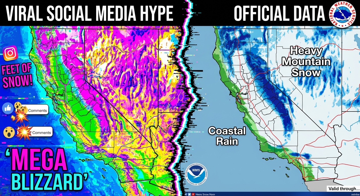
But for everyone in the valleys and on the coast, the story isn't snow. It is a Slight Risk for excessive rainfall and a Marginal Risk for severe thunderstorms. We are talking about a setup where the Bay Area celebrations for the Lunar New Year—which kicks off tomorrow for the Year of the Horse—are going to be soggy. If you have plans for outdoor festivals in San Francisco or near the coast, you need to have a Plan B.
Down in SoCal, from Santa Barbara to Los Angeles, we are watching a setup that could spin up a brief tornado or waterspout tonight. It is rare, but the wind shear is there.
The Danger No One Is Posting About
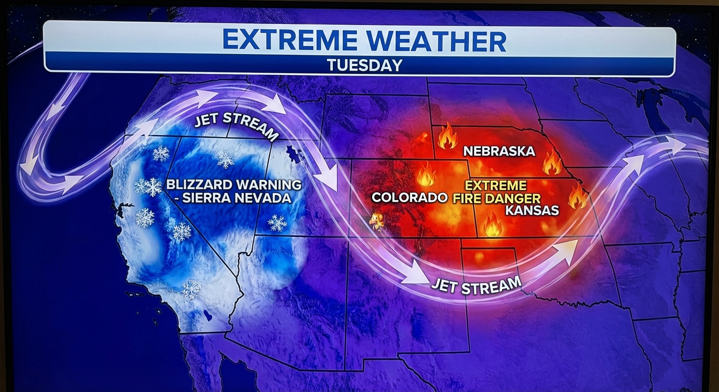
Here is what really keeps me up at night. While everyone is arguing about snow totals on Twitter, a life-threatening situation is developing in the Plains that is getting almost zero viral traction.
Tomorrow (Tuesday), we have an Extremely Critical fire weather risk for parts of Northeast Colorado, Southwest Nebraska, and Northwest Kansas.
- Winds: Sustained at 40 mph, gusts up to 70 mph.
- Humidity: Dropping as low as 10%.
- The Risk: Any fire that starts will spread uncontrollably fast.
This is the highest level of fire outlook the SPC issues. It is serious. But because fire maps aren't as "sparkly" as snow maps, they don't go viral. If you know anyone in places like Sterling, Colorado or North Platte, Nebraska, give them a call. Tell them to be careful with anything that creates a spark tomorrow.
The Takeaway
We are living in a split-screen reality this week. The West is buried in water and white stuff, while the Plains are dry and dangerous. And somewhere in the middle, the internet is trying to convince you that the apocalypse is coming.
Do me a favor. If you see a scary weather map tonight with zero source and neon colors, don't share it. Check the National Weather Service. Check the Storm Prediction Center. Or just come back here. We will keep it real with you.
Stay safe, watch out for those spin-ups in SoCal, and keep your head on a swivel in the Plains tomorrow.
https://ryanhallyall.com/blog/viral-snow-maps-vs-reality-why-your-feed-is-lying-to-you-tonight