Blog Article
Severe Storms Return to Midwest, Plus Seattle Snow Threat
A new severe weather threat targets the Midwest and Deep South this week, while critical fire danger hits Texas and snow levels crash in Seattle.

We Are Not Done Yet: New Severe Threats, High Plains Fire Danger, and a Seattle Snow Surprise
Alright folks, let's just take a deep breath. It has been a heartbreaking and exhausting weekend. As we talked about yesterday, that massive storm system transitioned from dropping massive tornadoes in the ArkLaTex region to a 1,000-mile line of severe storms that brought 90 mph winds right through places like Memphis.
Our thoughts are absolutely with everyone cleaning up today. But here is the thing. The atmosphere is not done yet. We have a very active week ahead of us, and I want to make sure y'all are prepared for what is coming next.
The Next Severe Weather Maker
While things are relatively quiet today outside of a Marginal Risk for some gusty storms in the Carolinas and southeast Virginia, we are watching the southern Plains reloading for the next couple of days.
On Monday, we have a Slight Risk (Level 2 out of 5) for severe thunderstorms across southern Arkansas, northern Louisiana, and Mississippi. The main threats here are going to be supercells capable of dropping some big hail. We are talking up to 2-inch hail, which will absolutely dent your car. There is also a 2 percent risk for isolated tornadoes. If you live in Little Rock, Shreveport, or Jackson, you need to have your weather radio on tomorrow.
Then things really ramp up on Tuesday. The Storm Prediction Center has already issued an Enhanced Risk (Level 3 out of 5) for northeast Missouri, far southeast Iowa, and northern and central Illinois. Places like Springfield and Peoria are right in the bullseye. A powerful upper-level system is going to merge with a cold front, dragging a ton of warm Gulf moisture northward. All severe hazards will be on the table for Tuesday, so if you are in the Midwest, please do not let your guard down.
Bone Dry in the Panhandles
While the eastern half of the country is dealing with severe storms and heavy rain, the High Plains are dealing with the exact opposite problem. It is bone dry out there.
We have a Critical Fire Weather area today and tomorrow for northeast New Mexico into the Oklahoma and Texas Panhandles. The humidity out there is crashing into the single digits. When you combine that incredibly dry air with 15 to 25 mph westerly winds coming off the mountains, any spark is going to spread like crazy.
If you live in Amarillo, Dumas, or Canyon, please avoid doing anything that could cause a spark. No outdoor burning, be careful with chains dragging on trailers, and don't toss cigarette butts out the window. If you are heading to the Santa Fe Outdoor Recreation event later this week, keep this dry pattern in mind.
A Pacific Northwest Snow Crash
Get this. While the South is dealing with severe weather and the Plains are dealing with fire, the Pacific Northwest is about to see a massive swing in temperatures and snow levels.
We have a deep, energetic system moving into Washington and Oregon. Right now, snow levels in the Cascades are sitting way up there around 6,000 to 7,000 feet. But a cold front is sweeping through, and those snow levels are going to crash rapidly.
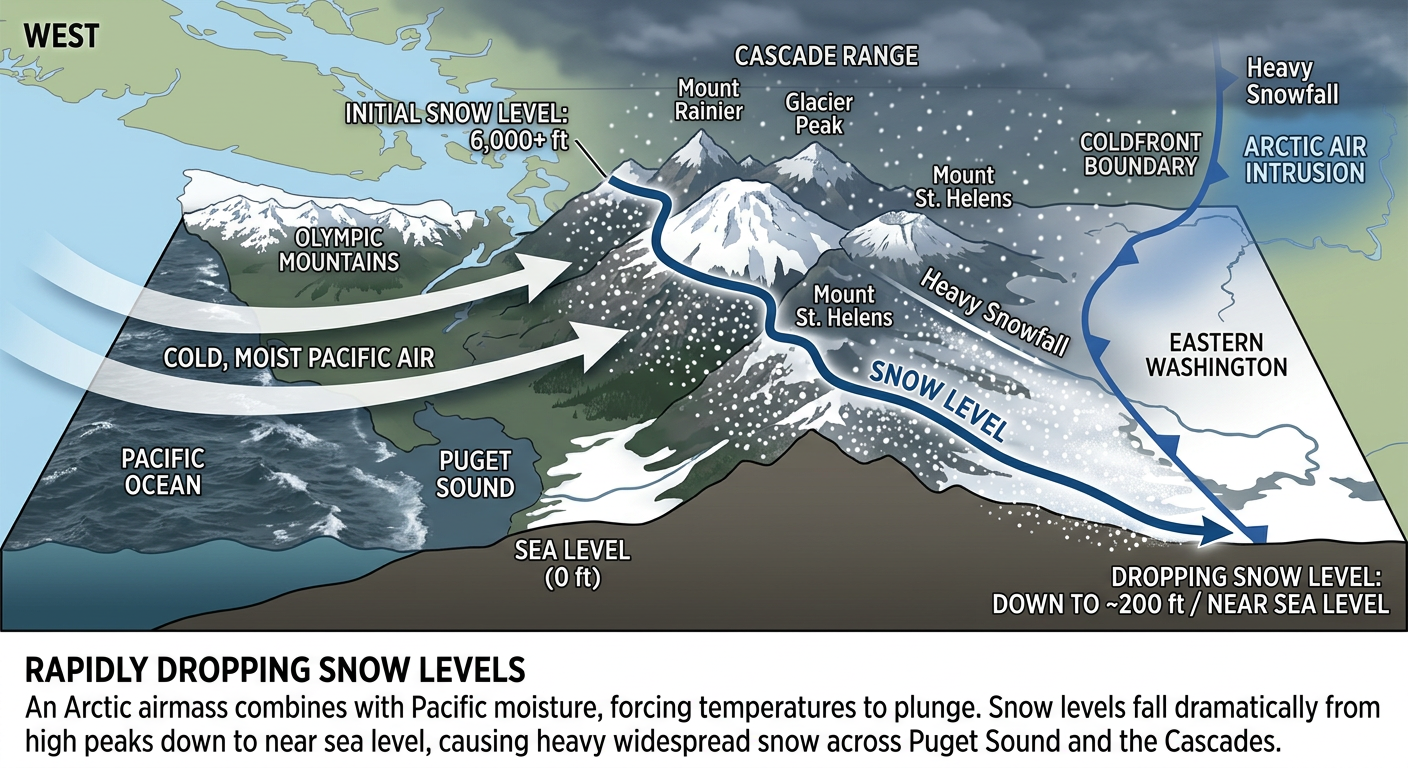
By Monday night and Tuesday morning, snow levels could drop to near 1,000 feet, and possibly all the way down to sea level. The National Weather Service in Seattle is closely watching a Puget Sound convergence zone that could bring accumulating snow right into the greater Seattle metro area. If you commute around the Puget Sound, Monday night and Tuesday morning could be a real mess. Leave early for your commute and make sure your car is ready for winter driving because this atmospheric river is going to bring heavy precipitation right into that trapped cold air.
Bottom Line
- Midwest & Deep South: Have multiple ways to get warnings on Monday and especially Tuesday. The severe threat is returning, and nighttime storms are possible.
- Texas & Oklahoma Panhandles: Critical fire danger is in place. One spark is all it takes today and tomorrow.
- Pacific Northwest: Get ready for a dramatic drop in snow levels. Seattle and the surrounding valleys could see a messy, wintry commute by Monday night.
Stay safe out there, y'all. We will keep tracking this and bring you the latest updates as we get them.