Blog Article
Level 4 Severe Weather Threat & Blizzard Impacts Today
A massive storm brings a Level 4 Moderate severe weather risk to the Mid-Atlantic, while intense lake-effect snow hits the Great Lakes. Get the latest forecast.

Weather Whiplash: Level 4 Severe East, Blizzards North, and Desert Heat
Welcome back, y'all. As we talked about yesterday while everyone was busy filling out their Selection Sunday brackets, a massive storm system was taking shape. Well folks, it has officially arrived, and it is bringing a nationwide weather whiplash today, March 16, 2026.
We are looking at a true clash of the seasons right now. We have got everything from a dangerous severe weather outbreak on the East Coast to lingering blizzards in the Upper Midwest, and even some 100-degree record heat out West. Let's break down exactly what you need to know to stay safe today.
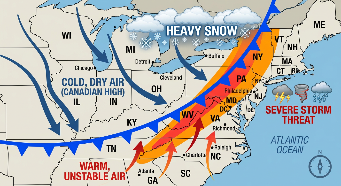
The Big Story: Level 4 Severe Threat for the Mid-Atlantic
Here is the thing that has my full attention today. The Storm Prediction Center has issued a Moderate Risk (Level 4 out of 5) for severe weather across parts of Maryland, Virginia, and North Carolina. This includes major hubs like Washington DC, Baltimore, Richmond, and Raleigh.
It is not often we see a Moderate Risk this early in the spring, and I know a lot of y'all have seen the trending news this morning about the statewide warnings in North Carolina. Get this, we are looking at a highly volatile environment. A fast-moving line of storms is going to sweep through, and it carries a massive 60% probability for widespread, damaging wind gusts.
But that is not all. There is a 15% hatched risk for tornadoes, meaning there is a very real potential for a couple of strong, long-track tornadoes to develop.
If you are in the Mid-Atlantic or Carolinas today:
- Have multiple ways to get warnings. Make sure your phone is charged and alerts are turned ON.
- If you have an afternoon commute, you might want to leave early or make a plan to shelter in place if storms hit while you are on the road.
- These storms are going to be moving incredibly fast. If a warning is issued for your area, you will not have much time to act. Take shelter immediately.
Winter's Not Done: Blizzards and Lake-Effect Snow
While the East Coast is dealing with severe storms, the Upper Midwest is still digging out from a historic blizzard. Places like Wisconsin and Michigan have already seen up to 28 inches of snow, and the Enhanced winter impacts are lingering today.
But here is where the story shifts. As this massive storm system pulls away into Canada, it is dragging down some intensely cold air behind it. We are talking about temperatures thousands of feet up in the atmosphere plunging to -20 degrees Celsius. When that freezing air blows over the relatively warm, unfrozen waters of the Great Lakes, the lake-effect snow machine is going to turn on overdrive.
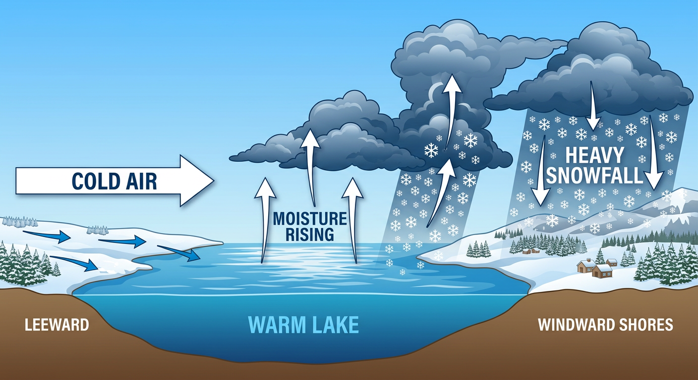
We are looking at a Slight Risk for heavy lake-effect snow starting tonight and going into Tuesday for the snowbelts east of Lakes Erie and Ontario. Places in Ohio, Pennsylvania, and New York could easily see 8 or more inches of snow.
If you live in Cleveland, Pittsburgh, or Buffalo, get ready to swing right back into your heavy hoodies and winter coats. Tomorrow morning's commute could feature absolute whiteout conditions in those heavy snow bands.
Meanwhile, the West is Baking
Just to show you how wild this pattern is, while folks in the Midwest are shivering and the East Coast is dodging tornadoes, the Desert Southwest is absolutely roasting. We have a record-breaking heatwave expanding across the Great Basin and the Southwest today. Highs are going to soar 20 to 30 degrees above normal, potentially cracking the 100-degree mark in parts of Arizona and California. Keep the AC running and stay hydrated if you are out that way.
Bottom Line
Today is one of those days where you really need to be weather-aware no matter where you live.
- East Coast: Treat this Level 4 severe risk seriously. Have your safe space ready and keep an eye on the radar this afternoon.
- Great Lakes: Prepare for a sharp drop in temperatures and sudden, blinding lake-effect snow squalls tonight into Tuesday.
- Southwest: Beat the heat and check on your vulnerable neighbors.
Stay safe out there today, y'all. We will keep tracking this beast of a system and keep you updated.
https://ryanhallyall.com/blog/weather-whiplash-level-4-severe-east-blizzards-north-and-desert-heat