Blog Article
Great Lakes Storm Threat & Wyoming Fire Danger
Tracking a Marginal Risk for severe storms in the Great Lakes and critical fire weather in Wyoming. See how unseasonable heat is fueling these threats.
Wyoming Fire Danger and a Great Lakes Storm Threat
Alright y'all, that massive heatwave we talked about yesterday is officially here. If you're heading out to the Houston Crawfish Kickoff Festival today, keep the water handy because it's gonna feel like the middle of summer. But while the South is baking, we've got a different situation unfolding up north. A low-amplitude upper wave is sliding along the Canadian border, and it's bringing a couple of distinct hazards with it.
Critical Fire Danger in the High Plains
Before we get to the storms, we have to talk about the dry air and wind. SPC has highlighted a Critical Fire Weather area for southeastern and central Wyoming today and tomorrow.
Here's the thing. We have dry downslope winds coming off the Rockies. When you combine relative humidity dropping below 15 percent with sustained westerly winds, any spark can turn into a raging wildfire. If you're driving along I-80 near Rawlins or up toward Casper, be extremely careful with anything that could start a fire. High-profile vehicles also need to be cautious of crosswinds in these areas.
Great Lakes Severe Threat
As that surface low deepens and pushes east over the Plains, it's gonna drag a lot of that southern warmth northward. Normally, Chicago sits around 47 degrees for a high this time of year. By Monday, they'll be pulling in air that is much warmer and more unstable.
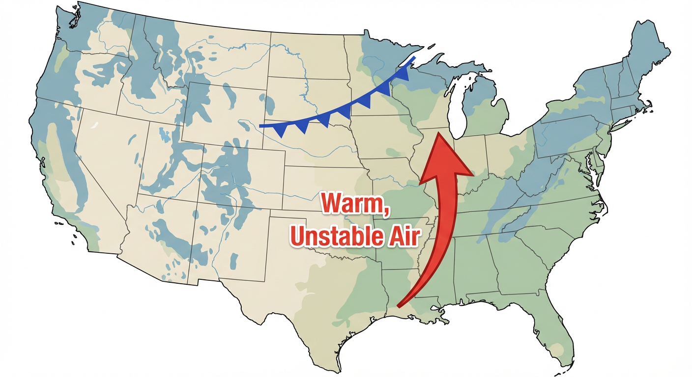
SPC has a Marginal Risk posted for the Upper Mississippi River Valley into the Great Lakes for late Monday night into early Tuesday morning. This includes Chicago, Milwaukee, and Detroit.
This isn't a panic-level outbreak setup, but it IS a situation where you need a way to get warnings while you sleep.
- The Timing: Storms are expected to fire off late Monday night and push east into Tuesday morning.
- The Threats: The main hazards are gonna be large hail and some damaging wind gusts.
- The Setup: A strong low-level jet is going to interact with that warm sector, allowing elevated supercells to develop after dark.
A Quick Look at Space Weather
Get this, we also had a bit of action on the sun. The Space Weather Prediction Center noted an M1.3 solar flare early this morning. It's causing some minor G1 geomagnetic storming. You probably won't notice it unless you're way up north looking for the aurora, but it's always fascinating to see how active our solar cycle is right now.
Bottom Line
If you live in Wyoming, observe all burn bans and avoid parking vehicles on dry grass today and Monday. For folks in the Great Lakes from Chicago over to Detroit, make sure your weather radio or phone alerts are turned on and loud before you go to bed Monday night.
https://ryanhallyall.com/blog/wyoming-fire-danger-and-a-great-lakes-storm-threat