Weather news
100-mile dust drift modeled after Friday's Army blast near Burlington, Iowa
By Ryan Hall, Y'all Weather Desk · Published
Written by our automated news desk from National Weather Service data.
Key points
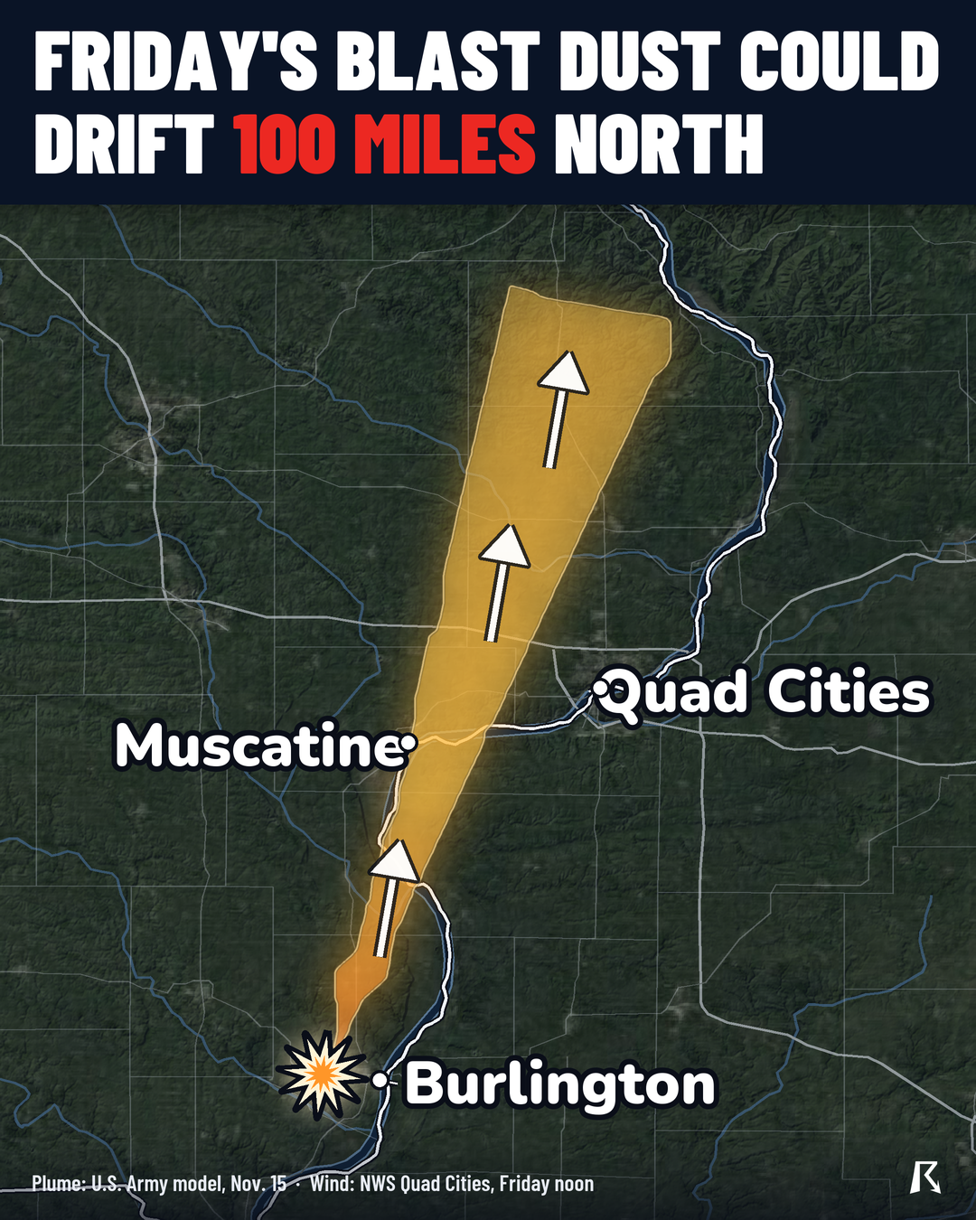
- Where: The plant at Middletown, Iowa, just west of Burlington. The modeled dust runs north-northeast, west of the Quad Cities, with Muscatine on the edge of the footprint, up to Jackson County near Maquoketa.
- When: Around noon Central on Friday, Nov. 20. Two detonations.
- What: The Army is destroying degraded lead azide. Its model shows where airborne lead could reach, about 100 to 105 miles.
- What it means: The wind forecast lines up with the model's direction. Anyone in that strip of eastern Iowa should know the plan and check the Army's advisory.
The Army will set off two controlled detonations of old lead azide at the Iowa Army Ammunition Plant in Middletown, just west of Burlington, around noon Central on Friday, Nov. 20. The Army's own model carries airborne lead dust about 100 to 105 miles north-northeast of the plant, and Friday's wind forecast at the plant is out of the south, which would carry it generally northward. The footprint passes west of the Quad Cities and ends near Maquoketa in Jackson County.
Where the dust could go
The footprint is the Army's, from a map it issued Nov. 15. It starts at the plant and stretches north-northeast about 100 to 105 miles. It runs west of the Quad Cities and clips the edge of Muscatine. It ends in Jackson County near Maquoketa.
The line is drawn at 0.18 micrograms of lead per cubic meter of air, which is the detection limit for the Army's sampling. So the map shows how far the model says the dust could reach. It does not tell us how much lead would be in the air at any one spot. We don't have the Army's amounts inside the footprint, so we can't say how much anyone would breathe.
Why the wind matters
Dust goes where the wind goes. The forecast wind at the plant on Friday is out of the south, which blows toward the north. That is the same direction the Army's model sends the dust, so the forecast and the footprint agree.
This is a two-day-out wind forecast. A shift in direction by Friday noon would move the dust somewhere else. The detonation time is also given as approximate. The Army's map was issued before this wind forecast, so check the wind again Friday morning. No severe weather is expected in Iowa on Friday.
What to do
- Read the Army's Updated Public Advisory, dated Nov. 17, in the Iowa Army Ammunition Plant section of army.mil/asc. It is the source for the timing and the plan.
- If you live or work along the strip from Burlington toward the edge of Muscatine, west of the Quad Cities and on to Maquoketa, know where you will be around noon Friday and follow any instructions from the Army or your county.
- Look at the wind Friday morning. If it has turned away from the north, the forecast wind no longer lines up with the modeled footprint.
- Watch active warnings for anything else going on that day, and sign up for free Y'all Alerts if you want updates sent to you.
Bottom line
Two controlled detonations are planned near Burlington around noon Central Friday, and the Army's own model plus a south wind point the dust about 100 miles north-northeast. The directions line up for now, but the wind forecast could still change by Friday.
More on November 2026 weather
Places in this story: Burlington, VT; Burlington, IA; Muscatine, IA; Maquoketa, IA