Weather news
3 to 6 inches of rain closes SR 520 at the Beachline east of Orlando Thursday
By Ryan Hall, Y'all Weather Desk · Published
Written by our automated news desk from National Weather Service data.
Key points
- Where: SR 520 at the SR 528 (Beachline) interchange east of Orlando, plus Florida's Space Coast in Brevard County.
- When: Closed now. The closure was extended to 1:15 PM ET, and steady rain keeps going through tonight and into Friday.
- What: 3 to 6 inches have fallen, based on radar and rain gauges. Brevard County has water rescues, flooded streets and water getting into homes.
- What it means: Skip this stretch of road today. More flooding is possible Friday (Level 3 of 4) and again Saturday (Level 2 of 4).
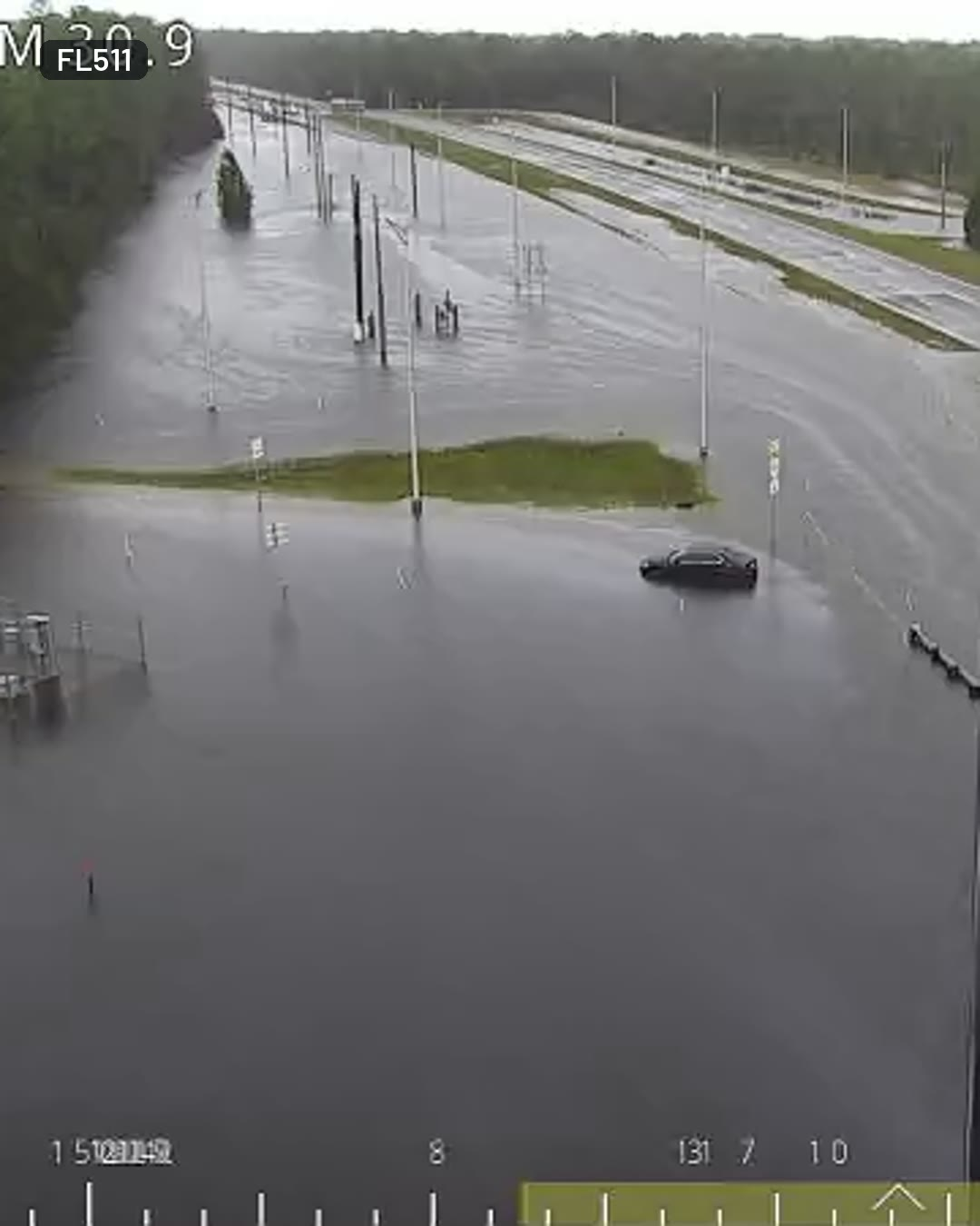
State Road 520 at the Beachline (SR 528) east of Orlando is under water and closed on Thursday, Nov. 19, after 3 to 6 inches of rain. The flooding is in Orange County, and neighboring Brevard County is under a Level 4 of 4 (High) flash flood risk through tonight. The rain is not done, so the closure could last.
SR 520 and the Beachline interchange are under water
A FL511 traffic camera at the interchange showed the water edge to edge at 12:12 PM ET. A dark sedan sat stopped in the middle of it, and a generator trailer was half submerged nearby. Cones and a truck were blocking a ramp on the right. Video credit: FL511.
The road was reported closed by flooding this morning. At 11:06 AM ET, the closure was extended to 1:15 PM ET. With rain still coming, check FL511 rather than planning around that time.
Brevard County is at the highest flash flood risk we have
Our flash flood outlook puts Brevard County, home of Cocoa Beach and Melbourne, at Level 4 of 4 (High) for today. That is the top of the scale. The upgrade came late this morning because of what is already happening there: water rescues, numerous flooded streets and water entering homes.
This is not a case of a few extreme downpours. The rain rates are not expected to be remarkable. The problem is that the rain has been steady for a long time, and the ground and drainage systems have nowhere left to put it. The flooding there is already at record levels, and every additional drop makes it worse. A brief burst of heavier storms with several inches per hour is possible and would make things worse quickly.
Farther south, the stretch from West Palm Beach to Fort Lauderdale is being watched. Slow-moving storms there have occasionally put down about 1 inch per hour, but so far only briefly.
Friday and Saturday keep the threat going
The heavy rain event on Florida's east coast continues Friday and Friday night. We have a Level 3 of 4 (Moderate) risk for portions of eastern and central Florida on Friday. Part of that rating reflects how saturated the ground will already be by Friday morning, not just how much new rain falls.
A new low is expected to form near the Bahamas and move north along the Southeast coast. On Saturday, Nov. 21, a Level 2 of 4 (Slight) flash flood risk covers coastal Florida, Georgia and South Carolina. There is a 50% chance this system becomes a subtropical or tropical storm. No named storm is active right now. The track is still uncertain, and a path farther offshore would cut the rain on land. This part is not locked in, but flooding is already happening today and a Level 3 risk remains for Friday.
Out west, a separate storm is dropping heavy snow on the Sierra Nevada. That is a different story, and you can follow it on our winter outlook page.
What to do
- Avoid SR 520 and the Beachline interchange today. Check FL511 and our interstate outlook for detours before you leave.
- Never drive into water over the road. The sedan in the camera shot is what that looks like, and it is hard to judge how deep the water is.
- In Brevard County, move cars and valuables up if you are in a spot that has already taken on water. Rain keeps falling through tonight, so flooding could worsen.
- Plan Friday around the Level 3 risk. Roads that drained overnight can flood again quickly on saturated ground.
- Watch for warnings. Our live warnings page shows every active one, and you can sign up for Y'all Alerts for free.
Bottom line
SR 520 at the Beachline is closed by 3 to 6 inches of rain, and Brevard County is at a Level 4 of 4 flash flood risk with more rain tonight and Friday. Stay off flooded roads, and be prepared for the closure to continue.
Explained: What the flash flood risk levels mean, from Level 1 to Level 4
More on Florida flooding, November 2026
Places in this story: Orlando, FL; West Palm Beach, FL; Fort Lauderdale, FL; Orange County, FL; Melbourne, FL; Cocoa Beach, FL