Flooding
Level 2 flood risk Saturday for coastal Georgia, South Carolina and North Carolina
By Ryan Hall, Y'all Weather Desk · Published · Updated
Written by our automated news desk from National Weather Service data.
What's new: Level 2 flood risk covers coastal sections of Georgia, South Carolina and North Carolina for Saturday

Key points
- Where: The coast and nearby counties of Georgia, South Carolina and North Carolina, with the heaviest rain from near Savannah to Wilmington.
- When: 7 AM ET Saturday to 7 AM ET Sunday.
- What: Heavy rain around a pair of low-pressure centers moving north along the coast.
- What it means: Flooding is possible, with the highest rainfall rates likely in coastal counties. Inland areas get a broader shield of moderate to locally heavy rain.
A Level 2 of 4 (Slight) flash flood risk covers coastal sections of Georgia, South Carolina and North Carolina from 7 AM ET Saturday, Nov. 21, until 7 AM ET Sunday. Heavy rain is expected from near Savannah, Georgia, to Wilmington, North Carolina, with the highest rainfall rates likely confined to coastal counties.
Conditions in Florida should slowly improve as the storm system moves north. Flooding is possible in the Level 2 area, and recent dry conditions should limit its coverage and severity.
Level 2 risk from near Savannah to Wilmington through Sunday morning
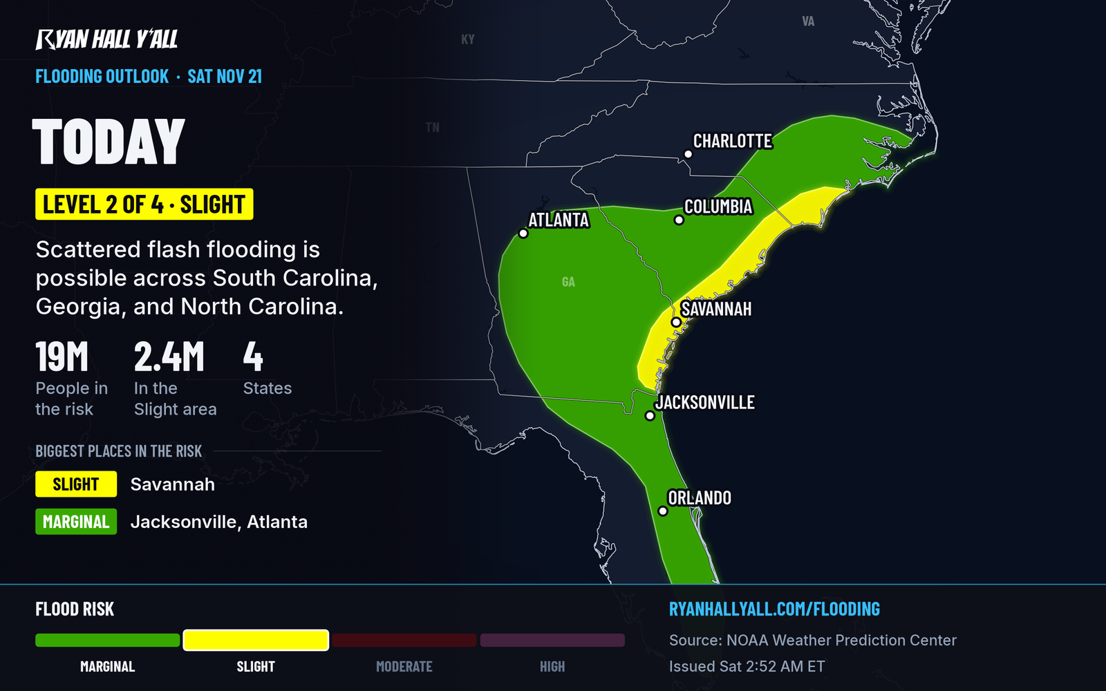
A storm system with two low-pressure centers will pull north to northeast, roughly parallel to the coast, through Saturday and Saturday night. A convective comma head and a possible coastal front are expected to produce heavy rainfall. The highest rain rates should stay in the coastal counties.
Farther inland, across central Georgia and central South Carolina, expect a wider area of moderate to locally heavy rain. We don't have a solid rain total to give you yet, so plan around the risk level rather than a number.
Flooding is possible from the Savannah area through Charleston to Wilmington, with the highest rainfall rates likely in coastal counties.
Florida eases, but the coast stays rough
Conditions across Florida should improve slowly through Saturday as the low moves away. A few alerts are still out:
- A flood warning for northern Brevard County runs until 8 AM ET Saturday for urban and small stream flooding.
- A coastal flood advisory for coastal Nassau, Duval and St. Johns counties runs until 5 PM ET Saturday for minor tidal flooding.
- A high surf advisory there calls for breaking waves of 6 to 9 feet until 7 AM ET Sunday, and the rip current risk stays high through Sunday.
How sure we are
The Level 2 covers the coastal Southeast. The computer models mostly keep the heaviest rain over the coastal waters, with the highest rainfall rates likely confined to coastal counties.
Much of this region has been dry lately, and that should limit how widespread and how bad any flooding gets.
What comes next
Sunday brings only Level 1 of 4 (Marginal) flood risks. One covers the Northeast, with 1 to 2 inches of rain from central New Jersey to southern Maine, peaking Sunday evening into early Monday. The other covers Deep South Texas, where some spots could see 2 to 4 inches Sunday into Sunday night.
What to do
- If you're driving along the Georgia, South Carolina or southeast North Carolina coast Saturday, leave extra time. Check your route first with our interstate driving outlook.
- Don't drive through water over the road. Turn around and take another way.
- Know where water collects near your home, and move vehicles out of those spots before the heaviest rain.
- Stay out of the surf in northeast Florida. Rip currents stay a problem through Sunday.
- Check the live warnings page if the rain turns heavy, and sign up for free Y'all Alerts for a ping if things change.
You can follow any change to the risk areas on our flash flood outlook page.
Bottom line
Saturday is a Level 2 flood day from near Savannah to Wilmington, with the highest rainfall rates likely in coastal counties. Flooding is possible, so keep out of flooded roadways.
Explained: What the flash flood risk levels mean, from Level 1 to Level 4, Flood Advisory, Watch, Warning and Flash Flood Warning explained
More on Southeast flooding, November 2026
Places in this story: Savannah, GA; Wilmington, NC; Charleston, SC
Sources
- WPC Day 1 Excessive Rainfall Outlook, NOAA Weather Prediction Center, issued
https://ryanhallyall.com/news/level-2-flash-flood-risk-for-the-carolina-and-georgia-coast-saturday