Weather news
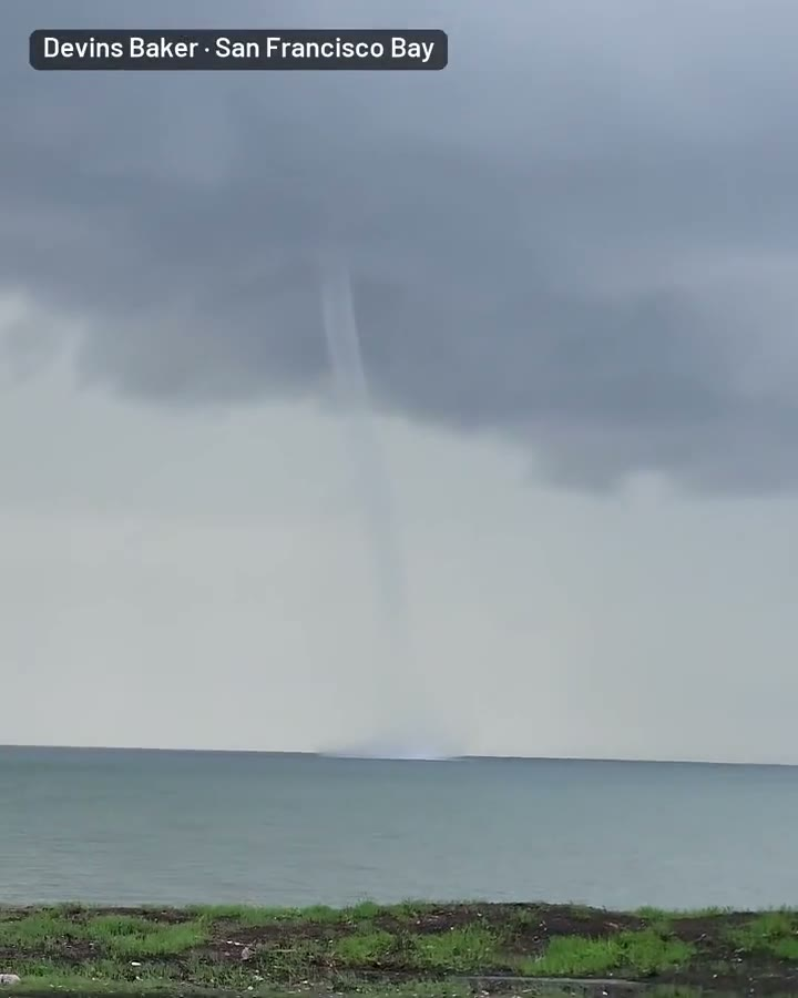
Waterspout over San Francisco Bay near Candlestick Point at midday Monday
By Ryan Hall, Y'all Weather Desk · Published
Written by our automated news desk from National Weather Service data.
Key points
- Where: San Francisco Bay south of the Bay Bridge, seen from Candlestick Point in San Francisco.
- When: Around noon Monday, Nov. 16. The marine warning ran 12:06 to 12:30 PM PST.
- What: A waterspout reported by the public and named in the warning.
- Same afternoon: Two tornado warnings were issued for Santa Cruz County, south of the bay.
- What's next: Another system reaches California on Wednesday, Nov. 18, with a Level 2 of 4 flash flood risk for the central coast and the Bay Area.
A waterspout formed over San Francisco Bay, south of the Bay Bridge, around noon Pacific time on Monday, Nov. 16. A viewer filmed it from Candlestick Point in San Francisco, and a Special Marine Warning covered that part of the bay from 12:06 to 12:30 PM PST. The warning said a waterspout had been observed and reported by the public.
You don't see this often on the bay, and the video shows the waterspout over the water.
What the video and the warning show
Devins Baker shot this video from Candlestick Point in San Francisco and posted it around 12:19 PM PST. It shows a waterspout over the bay itself. The Special Marine Warning was already in effect for the bay south of the Bay Bridge, and it noted that the public had reported the waterspout.
The warning expired at 12:30 PM PST.
Here is what we don't have: a rating, a track, or any word of damage or injuries. We'll only say what the video and the warning back up. A waterspout was seen and reported over the bay at midday Monday.
Tornado warnings in Santa Cruz County the same afternoon
Two tornado warnings also went out for Santa Cruz County on Monday afternoon. Santa Cruz sits along the coast south of the Bay Area. We have no confirmed tornado reports from the evidence on hand.
Nationally, no severe storms were outlined for Monday.
What's coming next in California
The pattern stays active this week. A new system brings another plume of Pacific moisture to California late Tuesday into Wednesday. Our flash flood outlook has a Level 2 of 4 (Slight Risk) for central coastal California and the Bay Area on Wednesday.
- Rain totals average 1 to 2 inches, with local amounts of 3 to 4 inches.
- Most of it falls in a 3 to 6 hour window as the front moves through.
- The moisture plume trended weaker than earlier runs, so this is not a long soaker.
In the mountains, a Winter Storm Warning for the Greater Lake Tahoe area runs from 4 AM Wednesday to 4 AM PST Friday. It calls for 2 to 4 feet of snow above 7,000 feet. Our winter storm outlook has the bigger picture.
What to do
- On the water: Check for marine warnings before heading out on the bay. If one is posted, get to shore.
- On the shore: Don't walk toward a waterspout for a closer look. Watch from a distance and keep an eye on the sky.
- Santa Cruz County: If a tornado warning is issued for your area, go to an interior room away from windows. Check active warnings for anything live.
- Wednesday: Plan for heavy rain and slow drives around the Bay Area and the central coast. Don't drive through water over the road.
- Sierra travelers: Expect heavy snow and tough pass conditions from Wednesday into Friday.
You can sign up for free Y'all Alerts to get warnings for your location.
Bottom line
A waterspout over San Francisco Bay around noon Monday, caught on video from Candlestick Point, was real and officially warned. No injuries or damage are in what we have. The bigger weather for California is Wednesday's rain and heavy Sierra snow from Wednesday into Friday.
Video: Devins Baker.
Explained: Watch vs. warning: what PDS watches and emergencies mean
More on West severe weather, November 2026
Places in this story: San Francisco, CA