Flooding
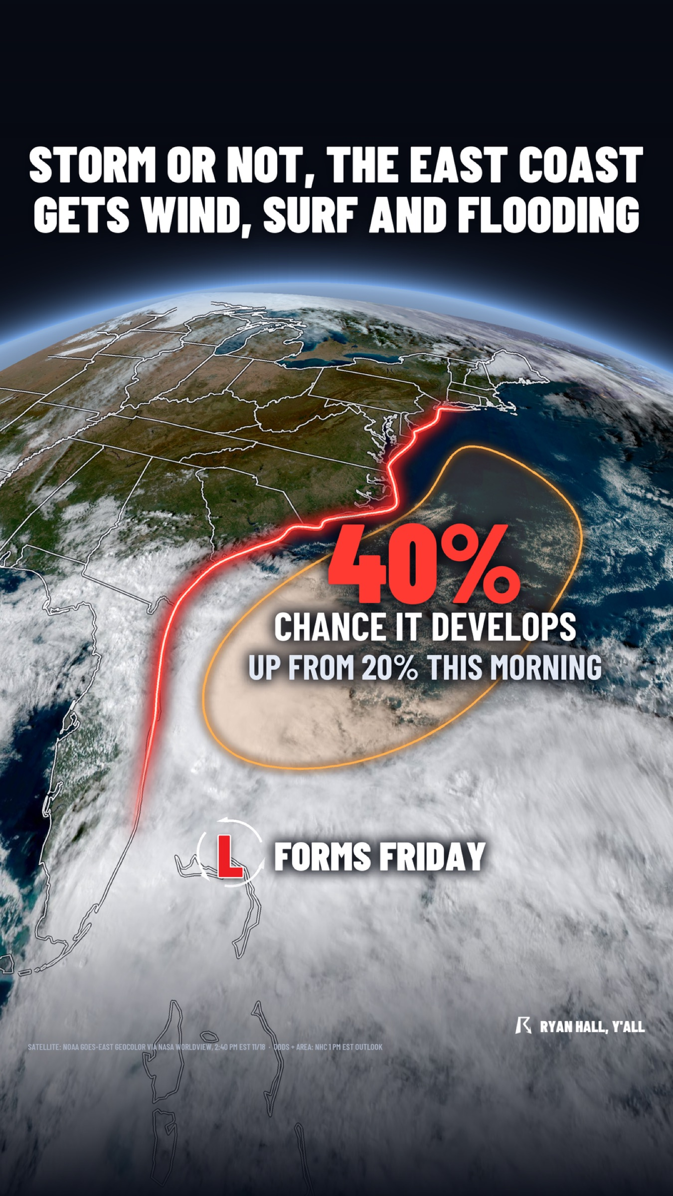
40% odds of a storm off the Southeast coast, with wind and flooding likely anyway
By Ryan Hall, Y'all Weather Desk · Published
Written by our automated news desk from National Weather Service data.

Key points
- Where: the Southeast coast up through the Mid-Atlantic, plus the Florida east coast for heavy rain.
- When: the low is expected to form near the northern Bahamas late Friday, Nov. 20. Wind, surf and flooding build through the weekend and into early next week.
- What: a 40% chance of tropical or subtropical development within 7 days. The chance within 48 hours is near 0%, so development before Friday is unlikely.
- What it means: the hurricane center says strong winds, dangerous surf and coastal flooding are likely along parts of those coasts regardless of development.
The Southeast and Mid-Atlantic coasts are likely to see strong winds, dangerous surf and coastal flooding this weekend into early next week, whether or not a storm gets a name. The National Hurricane Center now gives a low expected to form near the northern Bahamas late Friday, Nov. 20, a 40% chance of tropical or subtropical development within 7 days, double the 20% it had this morning.
That puts the trouble right at the start of Thanksgiving week. The exact track is still up in the air, but the coastal impacts are the part we are most confident about.
Why a storm with a 40% chance still matters
Forty percent is a forecast probability, not a guarantee that a storm will form. The part that doesn't hinge on a name is the setup itself. A non-tropical low is expected to form near the northern Bahamas by late Friday. From there it moves north or northeast, near or just offshore of the Southeast coast, through the weekend. It could become a subtropical or tropical storm along the way.
In its 1 PM EST outlook, the hurricane center added that interests along the eastern U.S. coast should monitor the system's progress. There are no active named storms right now. You can follow the latest on our tropics page.
How close the low tracks to the coast is the big unknown. We're watching how close it gets. The hurricane center's next outlook is due at 7 PM EST tonight.
Florida's east coast is already soaking
Florida's east coast has a separate, ongoing problem. We have a Level 3 of 4 (Moderate) flash flood risk up for parts of eastern Florida today, Thursday and Friday. Slow, back-building thunderstorms keep training along the coast, and the air is carrying more moisture than normal.
Some spots around Fort Lauderdale have already picked up a foot of rain in the last 24 hours. Thursday's heaviest rain centers on the Space Coast, where another 3 to 5 inches is possible. By Friday the heaviest rain creeps north to the Space and First Coasts, including the whole Jacksonville metro. Three-day totals well over a foot are possible in some places.
How far north the heaviest rain reaches toward Jacksonville is still uncertain, and that will decide how bad the flooding gets there. Friday's rain is tied to the low developing along a stalled front near Florida, so the same system that sets up the weekend's coastal trouble is soaking the ground first.
What to do
- If you live or vacation on the coast from Florida to the Mid-Atlantic: plan on rough water this weekend. Stay out of the surf, and keep boats in port or well secured.
- If you're in a spot that floods at high tide: move cars and gear off low streets before the weekend, and be ready for flooding on roads near the water.
- If you're traveling for Thanksgiving week: don't change plans yet. Check back Thursday and Friday for updates on the low's formation and track.
- In eastern Florida: don't drive into water over the road, especially overnight when it's hard to judge depth. Check active warnings before you head out.
- Want a heads-up when this changes? Sign up for free Y'all Alerts.
Bottom line
Coastal wind, surf and flooding are likely along parts of the Southeast and Mid-Atlantic coasts this weekend into early next week, with or without a named storm. The 40% chance of a tropical or subtropical storm is the part still in doubt, and the track will decide how strong the impacts are.
More on Florida flooding, November 2026
Places in this story: Fort Lauderdale, FL; Jacksonville, FL
Sources
- NHC advisories, NOAA National Hurricane Center