Forecasts
Cold blast brings Michigan snow and a Texas freeze before the Thanksgiving storm
By Ryan Hall, Y'all Weather Desk · Published
Written by our automated news desk from National Weather Service data.
What's new: First week-ahead look: 3 to 6 inches of lake-effect snow in Michigan's Upper Peninsula and a possible first freeze in parts of Texas lead the outlook before the Thanksgiving coastal storm.

Key points
- Monday, Nov. 23 and Tuesday, Nov. 24: Much colder air across the central and eastern U.S. Lake-effect snow around Lake Superior, and a first freeze for parts of Texas.
- Thursday, Nov. 26: Coastal low near the Outer Banks, heavy rain, strong wind and high surf along the East Coast. Wet snow is possible inland. Confidence in the storm is moderate, and low on the exact track.
- Monday into Tuesday: Wet Pacific storms continue in the Northwest and northern California, with mountain snow mostly limited to high elevations.
- Tropics: Quiet. No active storms or disturbances.
Lake-effect snow will bring 3 to 6 inches, with locally higher amounts in the Porcupine and Huron Mountains, to Michigan's Upper Peninsula from Sunday night through Monday afternoon. Parts of Texas may see the season's first freeze Monday or Tuesday, while hard freezes are possible in Oklahoma Monday. A coastal storm then brings strong wind and heavy rain along the East Coast on Thanksgiving Day, Thursday, Nov. 26. Our earlier story has I-95 from Washington to Boston in line for 1 to 2 inches, with snow possible from the central Appalachians through the interior Northeast. The storm track remains unsettled.
Day by day
- Monday, Nov. 23: Coastal rain ends across New England by afternoon after a wet morning commute. Lake-effect snow in Michigan's Upper Peninsula. Hard freezes are possible in Oklahoma. Heavy rain on the Olympic Peninsula in Washington. Showers in Florida.
- Tuesday, Nov. 24: Cool and cloudy across much of the country. Light snow possible on the southern and central High Plains. Wet in California and Oregon, and scattered storms in Florida.
- Wednesday, Nov. 25: The storm gets organized over the Gulf and crosses Florida. Mountain snow builds in the Washington and Oregon Cascades.
- Thursday, Nov. 26: Coastal low near the Outer Banks, then moving up the coast. Rain and wind along I-95, snow inland.
- Friday, Nov. 27: The cold front moves offshore and the system lifts over the Northeast. Snow lingers in the interior Northeast, northern Appalachians and lower Great Lakes.
- Saturday, Nov. 28: The East Coast storm tapers off. Rain and mountain snow continue in the Pacific Northwest and northern California.
- Sunday, Nov. 29: The East Coast storm has tapered off, while the wet pattern continues in the Pacific Northwest and northern California.
Cold blast Monday and Tuesday, with lake-effect snow
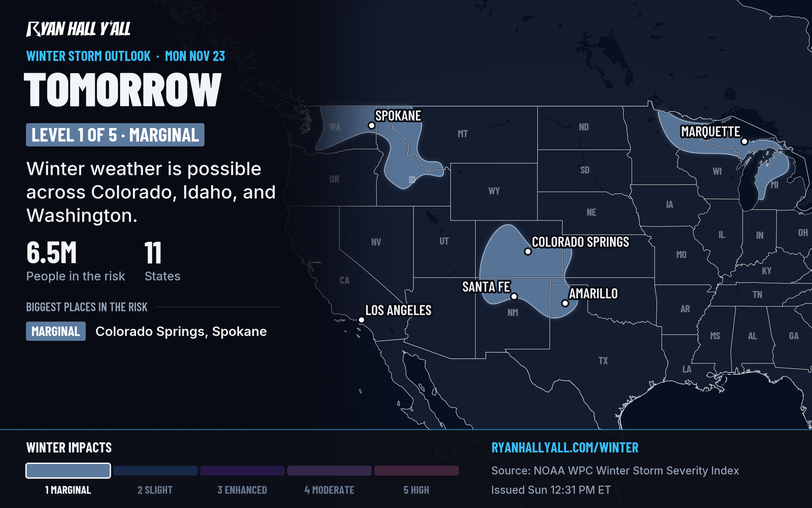
A strong cold front sweeps through the Ohio and Tennessee valleys, and much colder air settles over the central and eastern U.S. to start the week. Highs Tuesday run in the 40s across much of the central Plains and Midwest, with lows near freezing.
Lake-effect snow is the main winter hazard. Cold air crossing Lake Superior builds snow bands from Sunday night through Monday afternoon across Michigan's Upper Peninsula. Expect 3 to 6 inches, with locally more in the Porcupine and Huron Mountains, and sudden drops in visibility.
Parts of Texas see the season's first freeze. Hard freezes are possible in Oklahoma Monday. Our outlook has a Marginal risk of winter weather on the southern High Plains Monday and the southern and central High Plains Tuesday, where light snow or a wintry mix is possible in New Mexico. Bring in sensitive plants, protect pipes and wrap pets' outdoor shelters. Iowa's forecast low of 22°F Monday night is in our Iowa Army plant story.
Thanksgiving storm: heavy rain and wind on the coast, snow inland
A disturbance is expected to cross Florida and move northeast Thursday, forming a strong coastal low near or just offshore of the Outer Banks. Heavy rain, strong wind and high surf are expected along the East Coast. Our desk story on I-95 has the details on 1 to 2 inches of rain from Washington to Boston.
The exact track remains unsettled. Snow is possible from the central Appalachians through the interior Northeast, and our winter storm outlook shows a 0 to 15% chance of accumulating snow for the interior Northeast and western mountains by Thursday. That is a low-odds, early look, not a snow forecast. Severe storms are not expected because the substantial warm sector should remain offshore.
Wet Pacific pattern keeps going in the Northwest and California
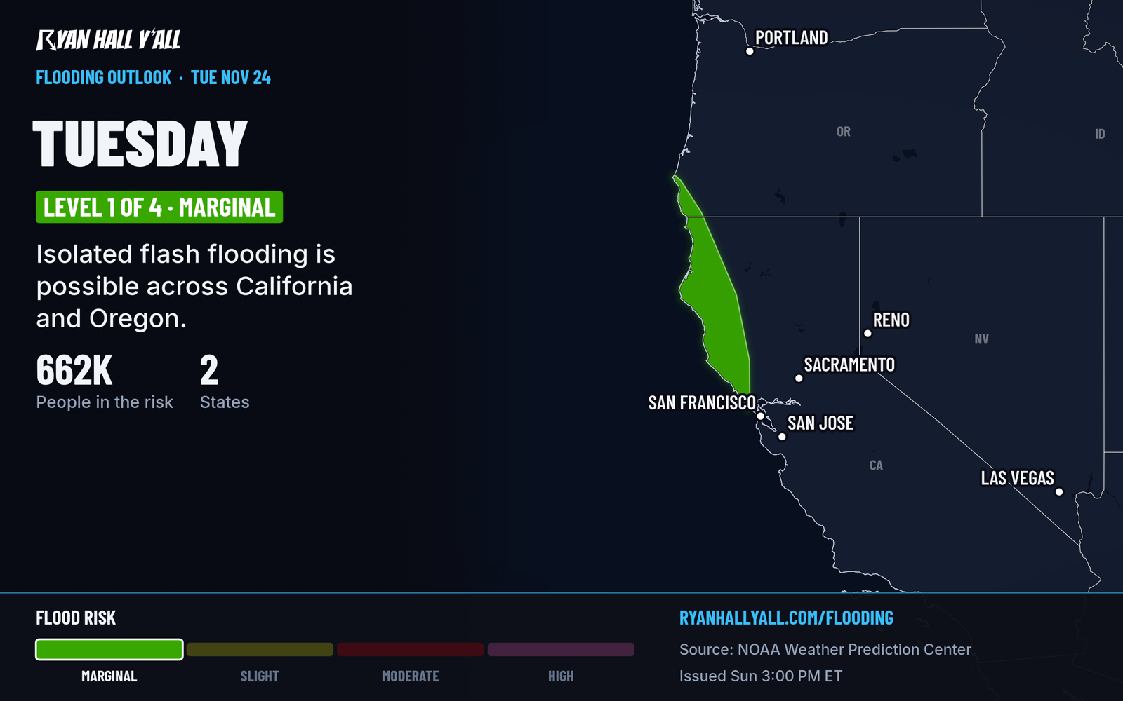
A stuck pattern sends Pacific storms into Washington, Oregon and northern California through the holiday weekend. Snow levels rise to over 5,000 feet by midweek, so most of this falls as rain. Only the highest elevations see accumulating snow.
The wettest spot Monday is the Olympic Peninsula, with up to 3 inches in the terrain and rises on the Skokomish River possible. Tuesday has a Level 1 of 4 (Marginal) flash flood risk over parts of California and Oregon, and Florida. The flash flood outlook has the latest. Wednesday into Thursday, moderate to locally heavy snow is expected on Cascade and northern Rockies passes. Check pass conditions before you leave.
Bottom line
Cold air and lake-effect snow come first, followed by the Thanksgiving coastal storm. Its track remains unsettled, and the Pacific Northwest stays wet all week.
More on Texas winter weather, November 2026
Places in this story: Boston, MA
Sources
- WPC Day 3 Excessive Rainfall Outlook, NOAA Weather Prediction Center, issued
- Ryan Hall, Y'all winter storm outlook, day 2 (our own outlook), Ryan Hall, Y'all, issued
- WPC Winter Storm Severity Index (WSSI), NOAA Weather Prediction Center
- Ryan Hall, Y'all winter storm outlook, day 5 (our own outlook), Ryan Hall, Y'all, issued