Forecasts
South Texas flash flood risk Sunday; strong Florida storms tonight
By Ryan Hall, Y'all Weather Desk · Published
Written by our automated news desk from National Weather Service data.
What's new: The Level 1 storm area in Florida was pushed north into central Florida this afternoon, a Tornado Warning is active, South Texas now carries a Level 2 of 4 flood risk for Sunday, and the Northeast flood area was trimmed.
Key points
- Lower Texas coast and eastern Rio Grande Valley, 6 AM Central Sunday to 6 AM Central Monday: Heavy rain, with 2 to 4 inches in spots and rates over 1 inch an hour. Don't drive into water over the road.
- Central and south Florida, this evening: Level 1 of 5 (Marginal) storms. A brief tornado or a damaging gust is possible.
- Western Oklahoma into south-central Kansas, this evening: Isolated strong to severe storms, also Level 1 of 5.
- Coastal Carolinas to southern New England, Sunday: Heavy rain moves north, with 1 to 2 inches from New Jersey to southern Maine and the heaviest Sunday evening into early Monday.
- Washington, Oregon and northern California mountains, tonight into Sunday: Snow levels drop to between 2,000 and 4,000 feet, so pass driving gets tricky.
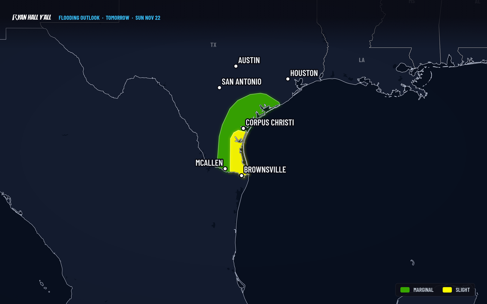
Flash flooding is possible along the lower Texas coast and in the eastern Rio Grande Valley on Sunday, Nov. 22, with 2 to 4 inches of rain in spots under a Level 2 of 4 (Slight) risk. Tonight, a few storms in central and south Florida and from western Oklahoma into south-central Kansas could turn severe. A Tornado Warning was also active as this went out.
South Texas flooding and storms Sunday
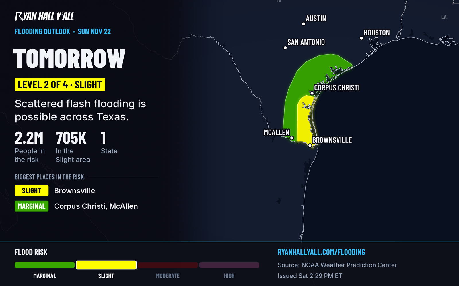
Gulf moisture increases ahead of a cold front that slows over South Texas. That sets up heavy rain from the Corpus Christi area south through Brownsville and McAllen. Totals of 2 to 4 inches are possible in spots, with isolated higher amounts. Our earlier desk story on the flood risk has the detail.
Storms should also get strong Sunday afternoon. This is Level 1 of 5 for Brownsville, McAllen, Alice and Corpus Christi. Quarter-size hail is the main worry, with an isolated damaging gust. Clouds should keep the tornado threat low.
A Coastal Flood Advisory for the Corpus Christi area and nearby Texas coast runs until 6 AM Central Monday. Expect minor coastal flooding.
Heavy rain is expected. Where the heaviest band sets up is uncertain, so treat the whole area as in play. Check the flash flood outlook Sunday morning.
Florida and the Plains: storms this evening
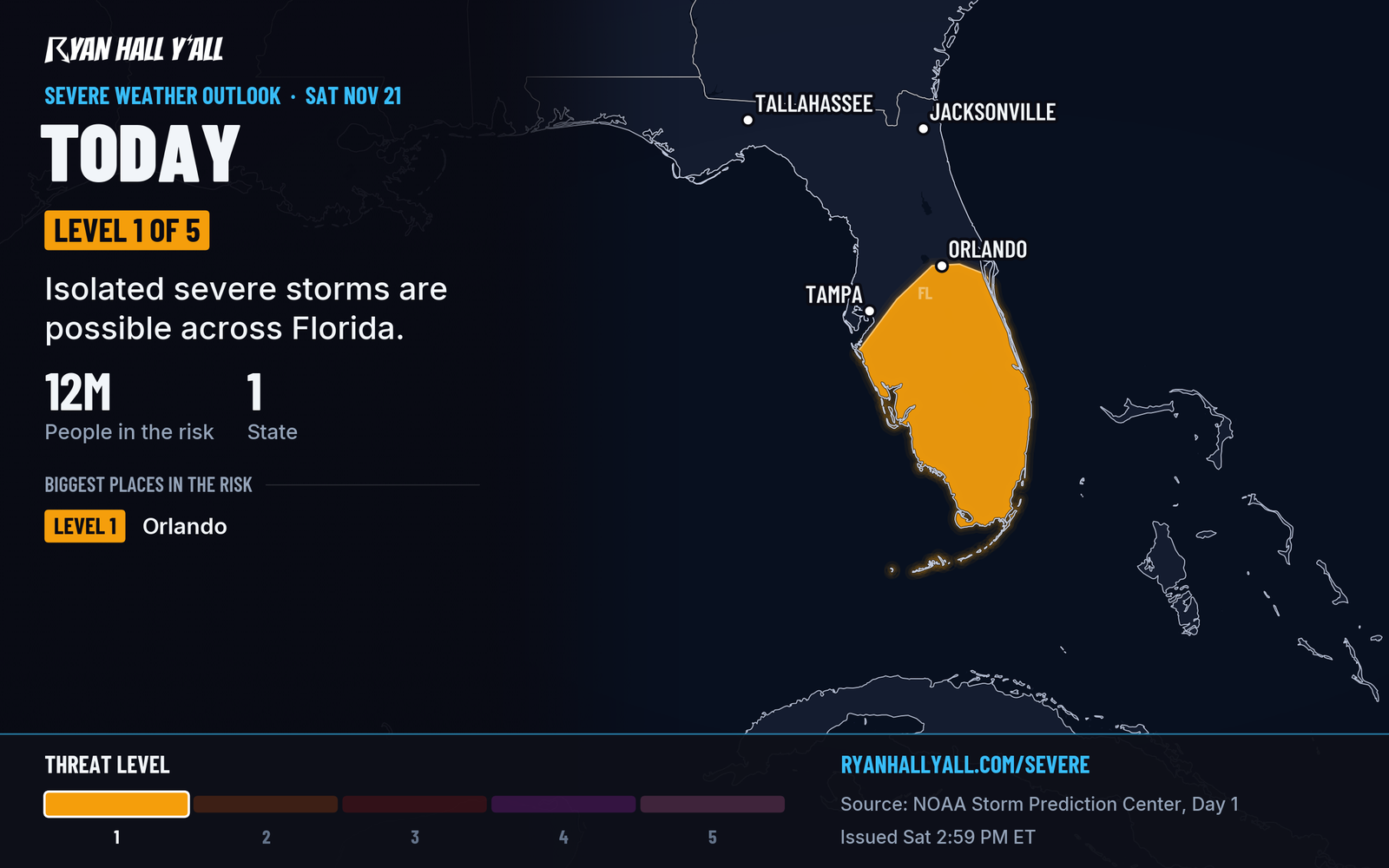
The Marginal risk area was pushed north this afternoon to cover central Florida, from near Lake Okeechobee toward Tampa Bay. A disturbance and a stronger southwest wind are feeding storms there, and some early rotation showed up. A brief tornado or a locally damaging gust is possible into this evening. The odds are low, about 2% for a tornado.
From western Oklahoma into south-central Kansas, isolated strong to severe storms are possible through this evening. Our live warnings page shows exactly where any Tornado Warning sits. If one covers you, move to an interior room on the lowest floor.
Northeast Florida is still dealing with last night's rain. A Flood Warning on the St. Johns River near Sanford says moderate flooding is happening and major flooding is forecast. Coastal Duval County has a Coastal Flood Advisory until 5 AM Eastern Monday, plus high surf of 5 to 7 feet through 10 PM tonight and dangerous rip currents. Skip the water.
East Coast rain builds Sunday
Rain eases over Florida, but heavy bands and a few thunderstorms linger along the coastal Carolinas Sunday morning. The coastal low then moves north. From eastern Virginia and the Delmarva through New Jersey, Long Island and southern New England, expect rain and strong onshore winds. Totals of 1 to 2 inches are likely, and the heaviest comes Sunday evening into early Monday. The flood risk there is Level 1 of 4, a notch below Texas. The exact rain axis in eastern New England is still uncertain. Beach erosion and tidal flooding are possible along the coast. The bigger coastal storm threat for Wednesday and Thanksgiving is in this desk story.
Snow in the Great Lakes and the West
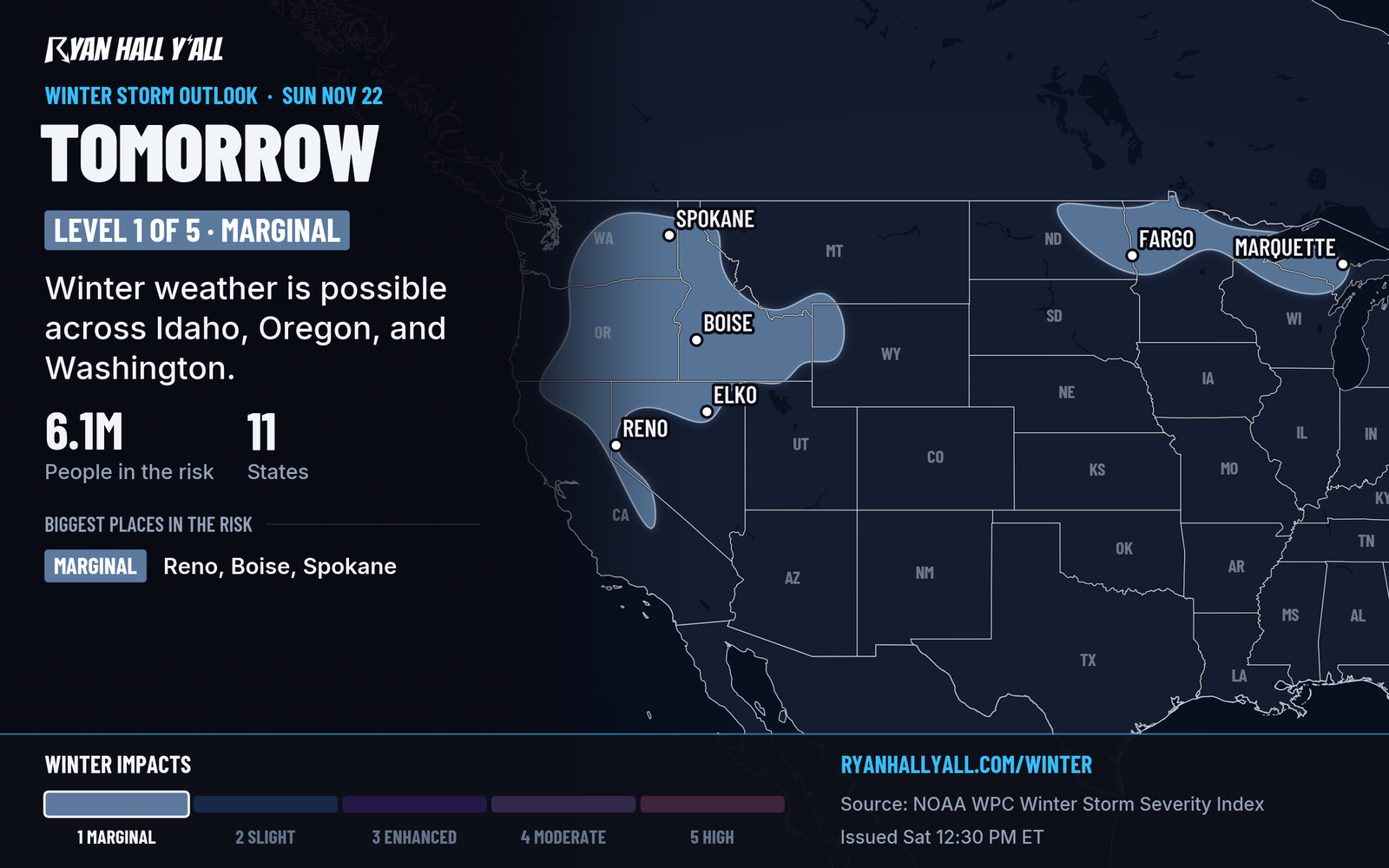
Colder air crossing the warm waters of Lake Superior will set off lake-effect snow in Michigan's Upper Peninsula. Locally 4 inches or more is possible in the Porcupine and Huron Mountains, and over 6 inches in the highest terrain. Behind the front, the central and northern Plains turn sharply colder after this week's record warmth.
In the West, a Pacific storm brings snow to the Cascades, the northern California ranges and the northern Sierra Nevada. Snow levels fall to about 2,000 feet in the Washington Cascades, 3,000 in the Oregon Cascades and northern California ranges, and 4,000 in the northern Sierra by Sunday morning. Odds of more than 4 inches are best above 4,000 feet in northern California and above 5,000 in the Sierra. Check the interstate outlook before crossing I-80 or I-5 passes.
San Francisco Bay's shoreline is also under a Coastal Flood Advisory until 6 AM Pacific Monday, then a warning through Thursday. The record-tide story is covered here.
Bottom line
South Texas gets the day's highest flood risk Sunday, so plan around water over roads from the Corpus Christi area to Brownsville. Tonight's storms in Florida and the southern Plains are low odds but worth a weather radio nearby. The East Coast rain builds Sunday evening and keeps going into Monday.
More on South Texas flooding, November 2026
Sources
- SPC Day 1 Convective Outlook, NOAA Storm Prediction Center, issued
- WPC Day 2 Excessive Rainfall Outlook, NOAA Weather Prediction Center, issued
- Ryan Hall, Y'all winter storm outlook, day 2 (our own outlook), Ryan Hall, Y'all, issued
- WPC Winter Storm Severity Index (WSSI), NOAA Weather Prediction Center
https://ryanhallyall.com/news/south-texas-flash-flood-risk-sunday-strong-florida-storms-tonight