Flooding
Level 2 of 4 flash flood risk across Texas on Sunday, Nov. 22
By Ryan Hall, Y'all Weather Desk · Published · Updated
Written by our automated news desk from National Weather Service data.
What's new: Added our HRRR model rain map for Sunday's flood window.

Key points
- Where: Texas is under the Level 2 of 4 flash flood risk. The heaviest rain is aimed at Deep South Texas.
- When: 6 AM Central Sunday to 6 AM Central Monday, with the heaviest rain Sunday into Sunday night.
- What: Downpours that can put water over roads quickly. Patchy totals of 2 to 4 inches are possible in Deep South Texas.
- What it means: Check your route before you go and never drive through water over the road. Severe storms are only a small concern (Level 1 of 5, Marginal).
Flash flooding is possible across Texas on Sunday, Nov. 22, with a Level 2 of 4 (Slight) flash flood risk from Sunday morning through early Monday. Deep South Texas has the best chance of heavy rain, with patchy totals of 2 to 4 inches possible Sunday into Sunday night. This is a modest risk level, not a big-event setup, but it is enough to change how you drive on Sunday.
Where the flash flood risk sits
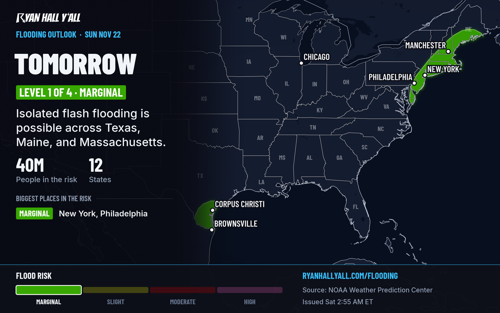
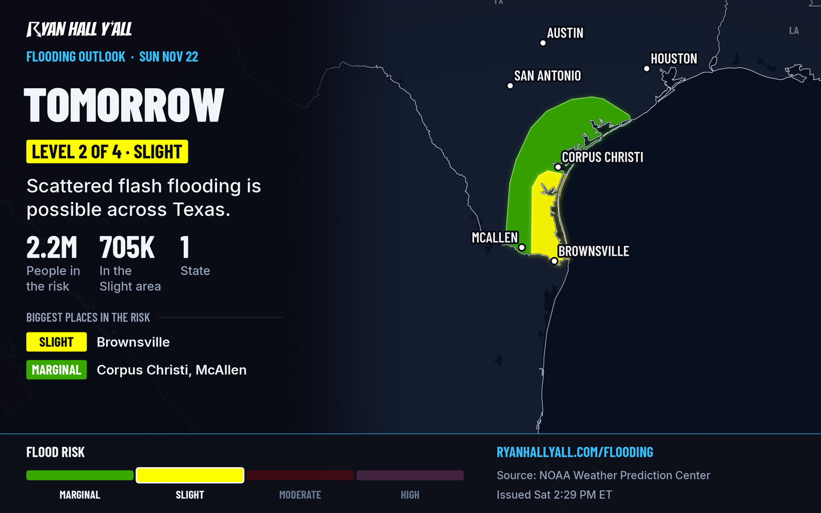
The flash flood outlook for Sunday puts Texas at Level 2 of 4. Earlier Saturday, the outlook was only a Marginal risk aimed at Deep South Texas. The afternoon update raised it to Level 2 over Texas.
The 2 to 4 inch figure is the high end for the heaviest storms. It is not a number for every town.
What our model rain map shows
The map above is our HRRR model rain total for the same window as the outlook, 6 AM Central Sunday to 6 AM Central Monday. It comes from the model run that started around noon Central Saturday. A single model run is one possible outcome, not a promise. The exact spots that get the heaviest bands can shift, so use the map to see the general rain footprint and lean on the outlook for the risk level.
Why Sunday's rain could add up
South to southeasterly winds are expected to quickly pump the air over Deep South Texas full of moisture, with more than 1.75 inches of precipitable water. A disturbance riding the subtropical jet stream adds lift, and the air is getting more unstable. That mix can produce patchy heavy rain.
Patchy is the key word. Some towns can pick up heavy rain while others a county away get much less. Water can pool on roads and rise in low spots fast, even at Level 2.
There is also a small severe storm chance. Sunday carries a Level 1 of 5 (Marginal) risk for Texas, which means a few stronger storms are possible but widespread severe weather is not expected.
How sure we are
The Level 2 of 4 risk for Sunday into early Monday is the current call. The exact spots that get the heaviest rain remain uncertain. The 2 to 4 inch totals come from earlier high-resolution guidance, and they could shift.
The Texas coast from the Corpus Christi area up to Calhoun County also has a Coastal Flood Advisory for minor flooding until 6 AM Central Monday. That is a separate issue from the rain, but it can make low-lying roads near the coast worse.
What to do
- Check your Sunday route before you leave, especially if you pass through low spots, underpasses or creek crossings.
- Don't drive into water over the road. You can't tell how deep it is or whether the road is still there under it.
- Know where to look. Our live warnings page shows every active warning, and you can sign up for free Y'all Alerts.
- Plan outdoor events with a backup. If you're heading to a game, a market or a trip across Texas, build in extra time and a rain plan.
- Keep your phone charged and have a way to get alerts if heavy rain arrives overnight Sunday.
For the severe side of the picture, our severe storm outlook has the latest.
Bottom line
Sunday, Nov. 22, brings a Level 2 of 4 flash flood risk to Texas, with patchy rain totals of 2 to 4 inches possible in Deep South Texas. Plan on slow travel, check warnings, and turn around if you see water over the road.
Explained: What the flash flood risk levels mean, from Level 1 to Level 4
More on South Texas flooding, November 2026
Places in this story: Corpus Christi, TX
Sources
- WPC Day 2 Excessive Rainfall Outlook, NOAA Weather Prediction Center, issued
- NOAA HRRR 2026-11-21 18Z, APCP 0-42 h minus 0-18 h (NOMADS filter), NOAA National Centers for Environmental Prediction
- HRRR, 2026-11-21T18:00:00+00:00 run, NOAA National Centers for Environmental Prediction
https://ryanhallyall.com/news/level-2-of-4-flash-flood-risk-across-texas-on-sunday-nov-22