Forecasts
First accumulating snow tonight into Friday: Poconos, Catskills, northern PA
By Ryan Hall, Y'all Weather Desk · Published
Written by our automated news desk from National Weather Service data.
What's new: The severe threat is ending in New Jersey and Delaware as the storm moves offshore, and the next story is the first accumulating snow in the interior Northeast tonight into Friday.

Key points
- New Jersey, eastern Pennsylvania, Delaware: The last of the severe threat moves offshore this evening. The Tornado Watch runs until 7 PM ET, and the remaining flash flood warnings expire by about 8 PM ET. Don't drive through water over the road.
- Poconos, Catskills, northern PA, southern NY, New England hills: Rain turns to wet snow tonight and snows into Friday evening. Heavy bands could drop 1 inch per hour. Expect slick roads Friday morning.
- Upper Peninsula of Michigan and central Appalachians: Lake-effect and upslope snow continue Friday. The Huron Mountains are favored for the biggest totals, with rates at times above an inch an hour.
- Sierra Nevada and the Pacific coast: Heavy snow, rapidly worsening pass travel and strong wind Friday, with rain moving into the West Coast.
- Interior Gulf Coast states, eastern Oklahoma, northern Arkansas: Freeze watches and frost or freeze advisories are up. Bring in tender plants and pets.
The first widespread accumulating snow of the season moves into the Poconos, the Catskills, northern Pennsylvania and southern New York tonight, and it keeps going through Friday evening. At least 4 inches is reasonably likely in parts of northern Pennsylvania, southern New York and the Catskills, mostly above about 1,500 feet. The tornado threat that hit New Jersey and Delaware this afternoon is ending as the storm slides offshore, and no severe storms are expected Friday.
Snow arrives in the interior Northeast tonight
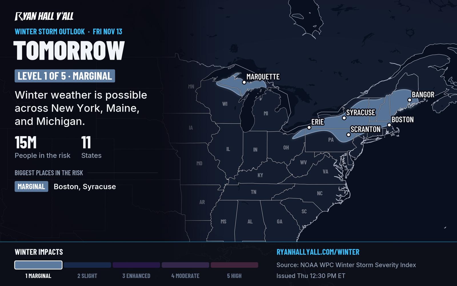
A second low is strengthening off the New Jersey coast. As it deepens, it pulls colder air south and builds a band of heavy precipitation to its northwest. That is what turns rain into wet snow over the hills.
Above about 1,500 feet, the change to snow is the confident part. That covers the Poconos, the Catskills, the hills of northern Pennsylvania and southern New York, and higher ground in Vermont, New Hampshire and the Berkshires. Lower down, you will see rain changing to wet snow or slush. Where the heaviest band sets up, snow could reach closer to valley level than usual.
The track has trended colder and a bit farther south today, which puts northeast Pennsylvania and south-central New York in the best spot. Exactly where the 4-inch-plus totals land, and how far down the hillsides they reach, is still being sorted out. Northern New England has the most uncertainty on timing.
Leave extra time for Friday morning commutes in the hills. Along the New York City shoreline, the main issue is rain, with minor coastal flooding possible near high tide.
Tonight's storms wind down in New Jersey
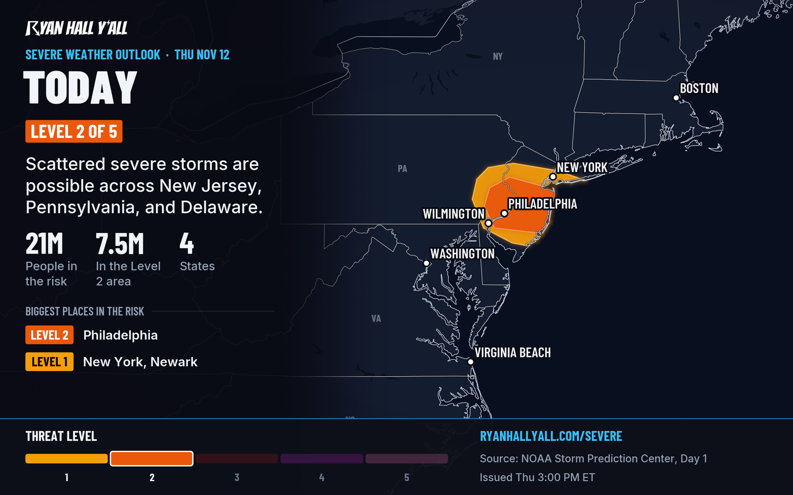
A tornado touched down near Wilmington, Delaware, and a tornado was radar-confirmed near Crosswicks, New Jersey. The Level 2 of 5 (Slight Risk) area covers southeast Pennsylvania and central and southern New Jersey. The threat shifts east with the low and ends as it exits the coast. If you are in the New Jersey area, check live warnings until the watch expires.
Sierra snow and a wet Northwest
Winter Storm Warnings are up for the Sierra Nevada, and High Wind Watches and Advisories cover parts of Nevada, California and Oregon. Snow near 1 to 3 inches per hour is possible in the northern Sierra Friday as snow levels drop fast.
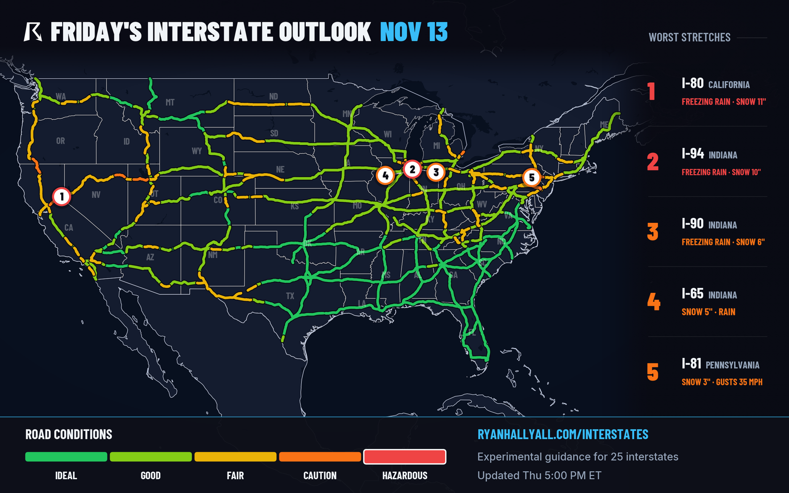
Our interstate outlook rates I-80 as Hazardous Conditions Friday, driven by the Sierra snow around Donner Pass. Plan around hazardous conditions if you have to cross.
Rain returns to the Pacific Northwest Friday. A second, wetter surge Saturday night, Nov. 14, into Sunday brings 1 to 3 more inches to the Olympic Peninsula, with a Level 1 of 4 (Marginal) flash flood risk. We covered the setup in our Seattle desk story.
Freeze watches in the South
Cold air follows the storm. Freeze watches are posted for parts of the interior Gulf Coast states, southeastern Virginia and north-central North Carolina. Freeze warnings and frost advisories cover eastern Oklahoma and northern Arkansas. Protect plants and bring in pets, and check the weekend forecast alerts signup if you want a ping when this changes.
Bottom line
Tonight's story is rain turning to wet snow over the hills of the interior Northeast, with the heaviest snow above 1,500 feet through Friday evening. The severe threat is done once the storm clears the New Jersey coast, and Friday has no severe risk. Check our winter outlook before you drive in the hills Friday morning.
More on Mid-Atlantic winter weather, November 2026
Sources
- SPC Day 1 Convective Outlook, NOAA Storm Prediction Center, issued
- Ryan Hall, Y'all winter storm outlook, day 2 (our own outlook), Ryan Hall, Y'all, issued
- WPC Winter Storm Severity Index (WSSI), NOAA Weather Prediction Center
- Ryan Hall, Y'all interstate travel outlook (our own outlook), Ryan Hall, Y'all, issued