Forecasts
Florida Level 3 flood risk grows to Jacksonville Friday, Nov. 20
By Ryan Hall, Y'all Weather Desk · Published
Written by our automated news desk from National Weather Service data.
What's new: The Level 3 of 4 flood risk for Friday now takes in the whole Jacksonville metro, Broward and Miami-Dade schools closed for Thursday, and a low expected to form near the northern Bahamas by late Friday has a 40% chance of tropical or subtro
Key points
- Florida east coast, Thursday: The Moderate flood risk runs from the Treasure Coast and Space Coast up toward the southern First Coast. Expect flooded streets and rising rivers. Don't drive through water over the road.
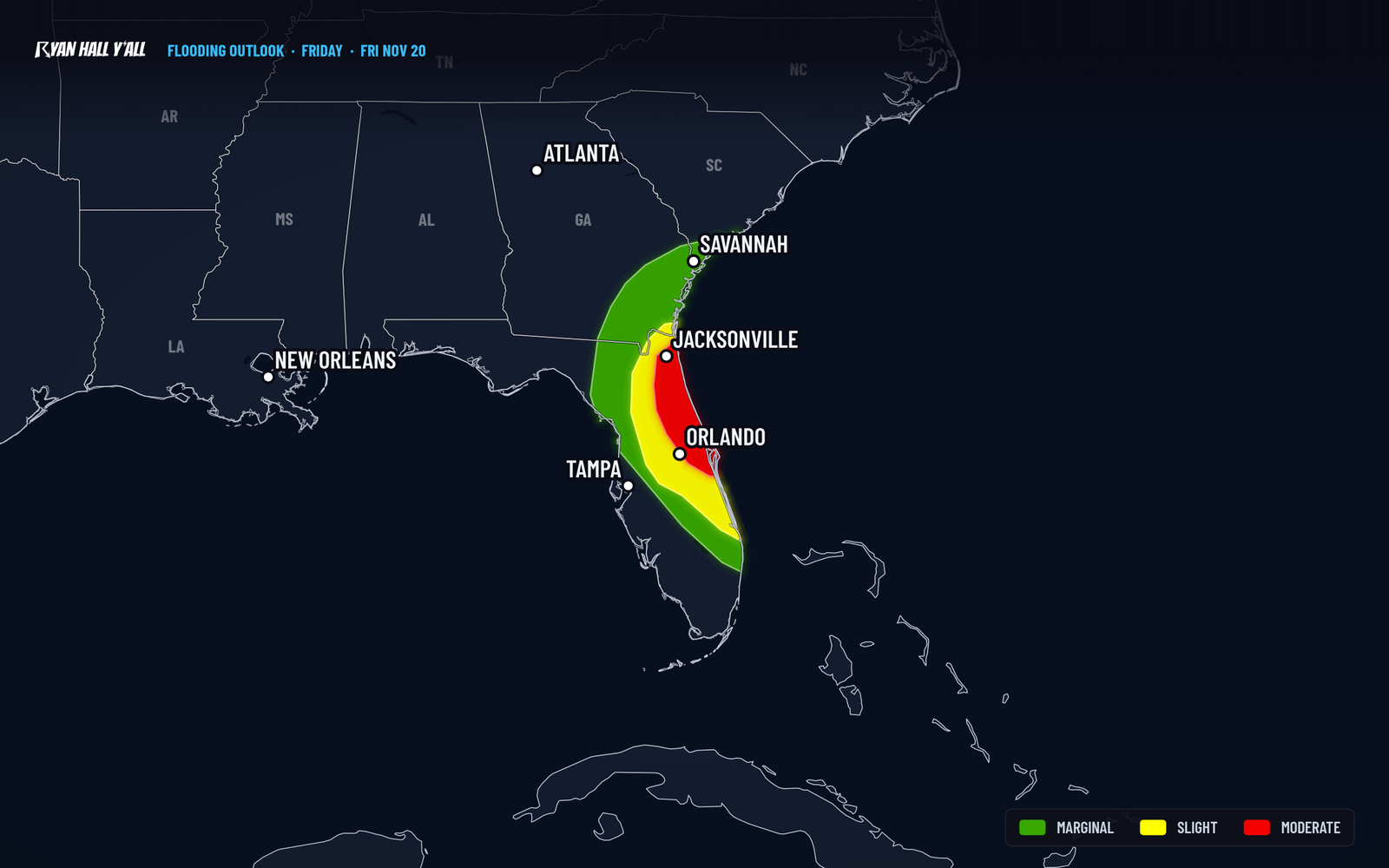
- Jacksonville and Orlando, Friday: Jacksonville is now fully in the Level 3 area. Orlando sits just under it at Level 2 of 4 and could be raised.
- Southeast coast, this weekend into early next week: A low is expected to form near the northern Bahamas by late Friday. Wind, surf and coastal flooding are likely whether or not it gets a name.
- Sierra Nevada, Thursday: The heaviest snow falls from about 10 AM to 10 PM PST, with 2 to 4 feet above 5,000 feet and travel on I-80 and US-50 difficult to impossible.
- Los Angeles area, Thursday: Heavy rain could total 3 to 5 inches, with burn scars under an evacuation warning.
The Level 3 of 4 (Moderate) flash flood risk now covers the entire Jacksonville metro on Friday, Nov. 20, up from the earlier outline that stopped short of the city. Before that, Thursday, Nov. 19, is the wettest day for Florida's Space Coast, with another 3 to 5 inches of rain and locally 5 to 10 inches where storms train over the same spots. Broward and Miami-Dade public schools are closed Thursday because of flooding. Out West, the heaviest Sierra snow peaks Thursday.
Florida's flood zone moves north
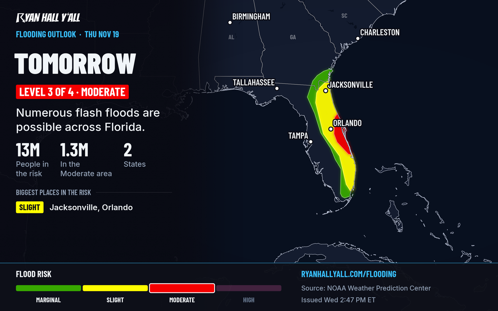
This is a multi-day event, and the ground is already full. Parts of the Fort Lauderdale area picked up about a foot of rain in 24 hours.
The rain shield has slowed its crawl up the coast, so the Space Coast takes the worst of it Thursday. Storms can dump multiple inches an hour and repeat over the same neighborhoods. That is how a normal downpour turns into street flooding in an hour.
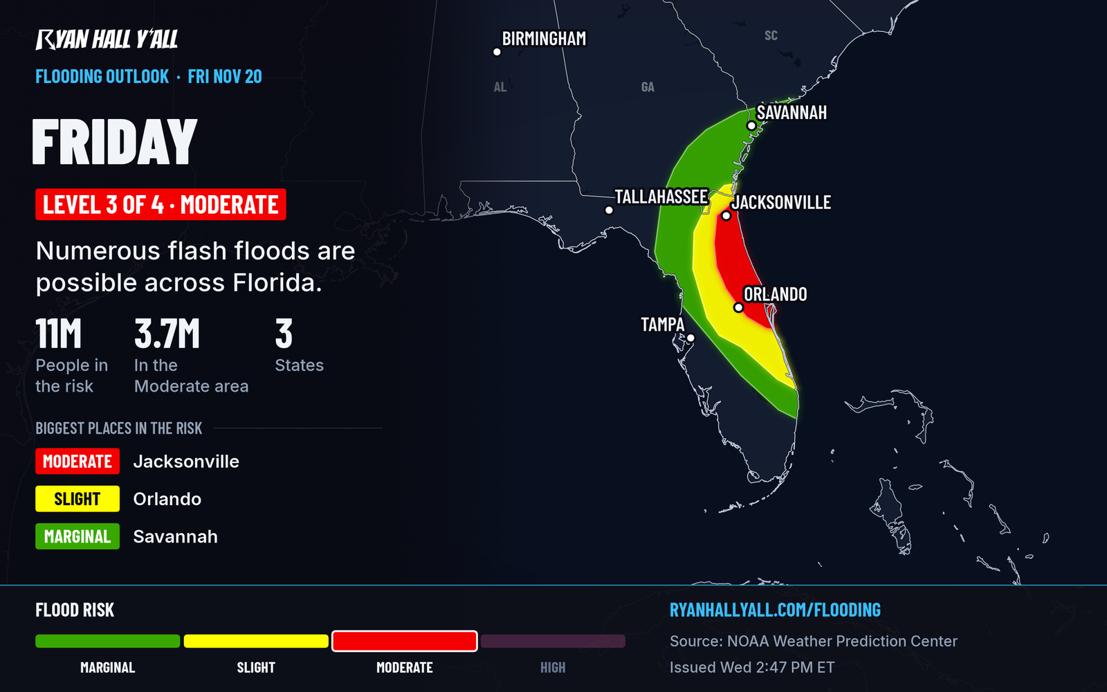
By Friday the heaviest rain has moved far enough north that South Florida gets a break. The Space and First Coasts are next, with Jacksonville now fully inside the Level 3 area. Rivers there are high, so more rain matters more.
What to do tonight: move cars out of low spots, charge phones, and plan Thursday's commute around water on the road. If you're in Jacksonville, don't wait until Friday to get ready. Our flash flood outlook updates through the day. The earlier desk story has the Hollywood totals: 5.86 inches of rain floods Hollywood, Florida.
A low expected near the northern Bahamas has a 40% chance of development
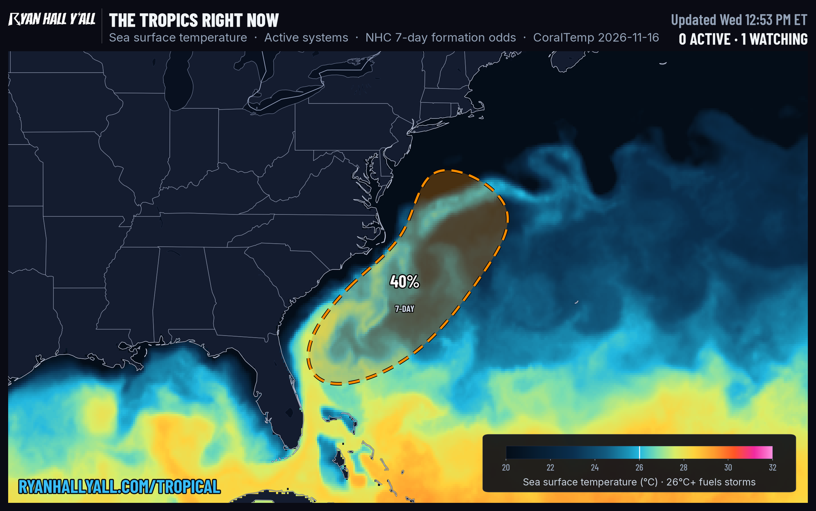
No tropical storm exists tonight. The National Hurricane Center expects a non-tropical low to form near the northern Bahamas by late Friday. It could become a subtropical or tropical storm as it moves north or northeast near or off the Southeast coast through the weekend. Odds of development are near 0% over the next two days and 40% over seven days.
The wind and water threat doesn't depend on a name. Strong winds, dangerous surf and coastal flooding are likely along parts of the Southeast and Mid-Atlantic coasts into early next week. The track is still uncertain, so check back Thursday and Friday before making weekend beach or boating plans. See the tropics page for updates.
Sierra snow peaks Thursday and spreads east
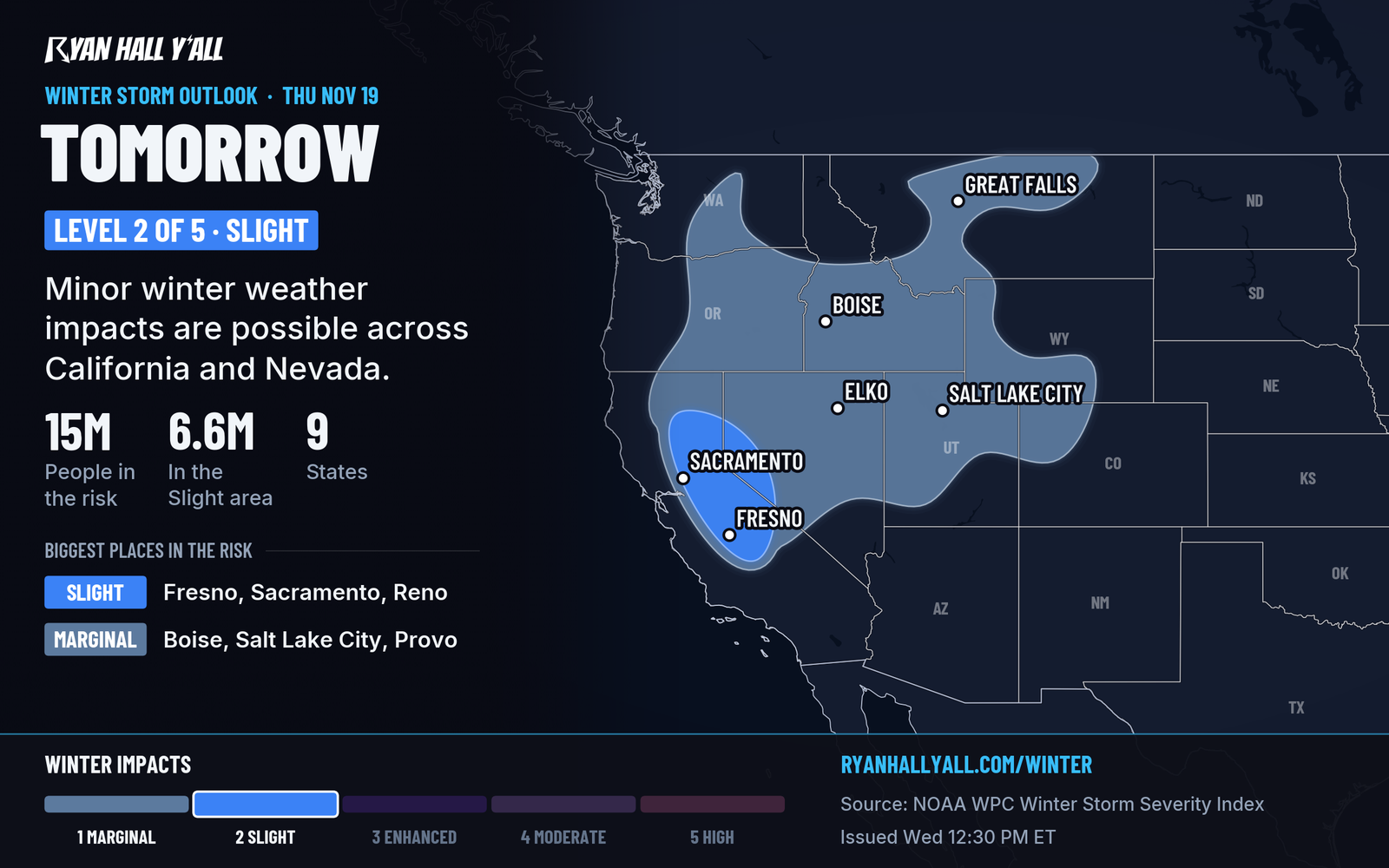
A Winter Storm Warning runs until 4 AM PST Friday. Totals are 2 to 4 feet above 5,000 feet, up to 5 on the highest peaks, and 1 to 2 feet at Lake Tahoe's shore. Snow may fall 2 to 3 inches an hour, with gusts to 60 mph and up to 100 mph along ridgetops. If you don't have to cross Donner Pass or Echo Summit Thursday, don't. Our winter storm outlook has the details, and the desk story is here: 1 to 2 feet of snow at Lake Tahoe's shore.
Thursday into Friday, snow spreads across western and central Nevada, southern Idaho, Utah, western Wyoming and western Colorado. Nevada valley floors may get 2 to 5 inches, and the mountains more.
California rain, with a small storm chance
Los Angeles has an evacuation warning for burn scars as 3 to 5 inches of rain could fall Thursday. Burned slopes can send mud and debris into neighborhoods below, so know your route out. Details: LA burn scars under evacuation warning.
The San Joaquin Valley, including Fresno, has a Level 1 of 5 (Marginal) severe risk Thursday afternoon. Odds are 2% for a tornado and 5% for damaging gusts. Most storms stay weak. San Francisco Bay shoreline areas have a Coastal Flood Advisory until 10 AM PST Friday for up to 1.2 feet of water in low spots.
Bottom line
Florida's flood threat shifts north from Miami to Jacksonville through Friday, and a coastal low could bring wind and surf to the Southeast this weekend. Thursday is also the Sierra's peak snow day.
More on Florida flooding, November 2026
Places in this story: Jacksonville, FL; Miami, FL; Orlando, FL; Los Angeles, CA
Sources
- WPC Day 2 Excessive Rainfall Outlook, NOAA Weather Prediction Center, issued
- WPC Day 3 Excessive Rainfall Outlook, NOAA Weather Prediction Center, issued
- Ryan Hall, Y'all winter storm outlook, day 2 (our own outlook), Ryan Hall, Y'all, issued
- WPC Winter Storm Severity Index (WSSI), NOAA Weather Prediction Center
https://ryanhallyall.com/news/florida-level-3-flood-risk-grows-to-jacksonville-friday-nov-20