Flooding
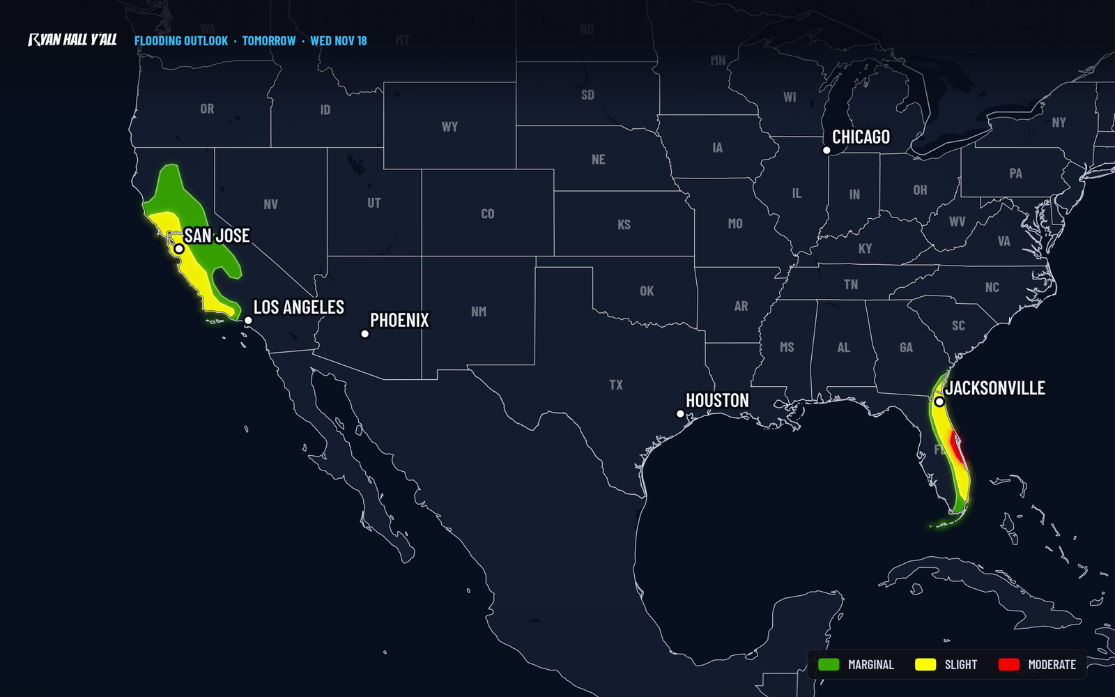
Florida Level 3 of 4 flash flood risk Wednesday, Space and Treasure Coasts
By Ryan Hall, Y'all Weather Desk · Published · Updated
Written by our automated news desk from National Weather Service data.
What's new: Level 3 area now pinned to St. Lucie through Brevard County, could extend toward Jacksonville; California details corrected
Key points
- Where: Florida's east coast, with the Level 3 focus from St. Lucie County to Brevard County. The risk area could grow north toward Jacksonville.
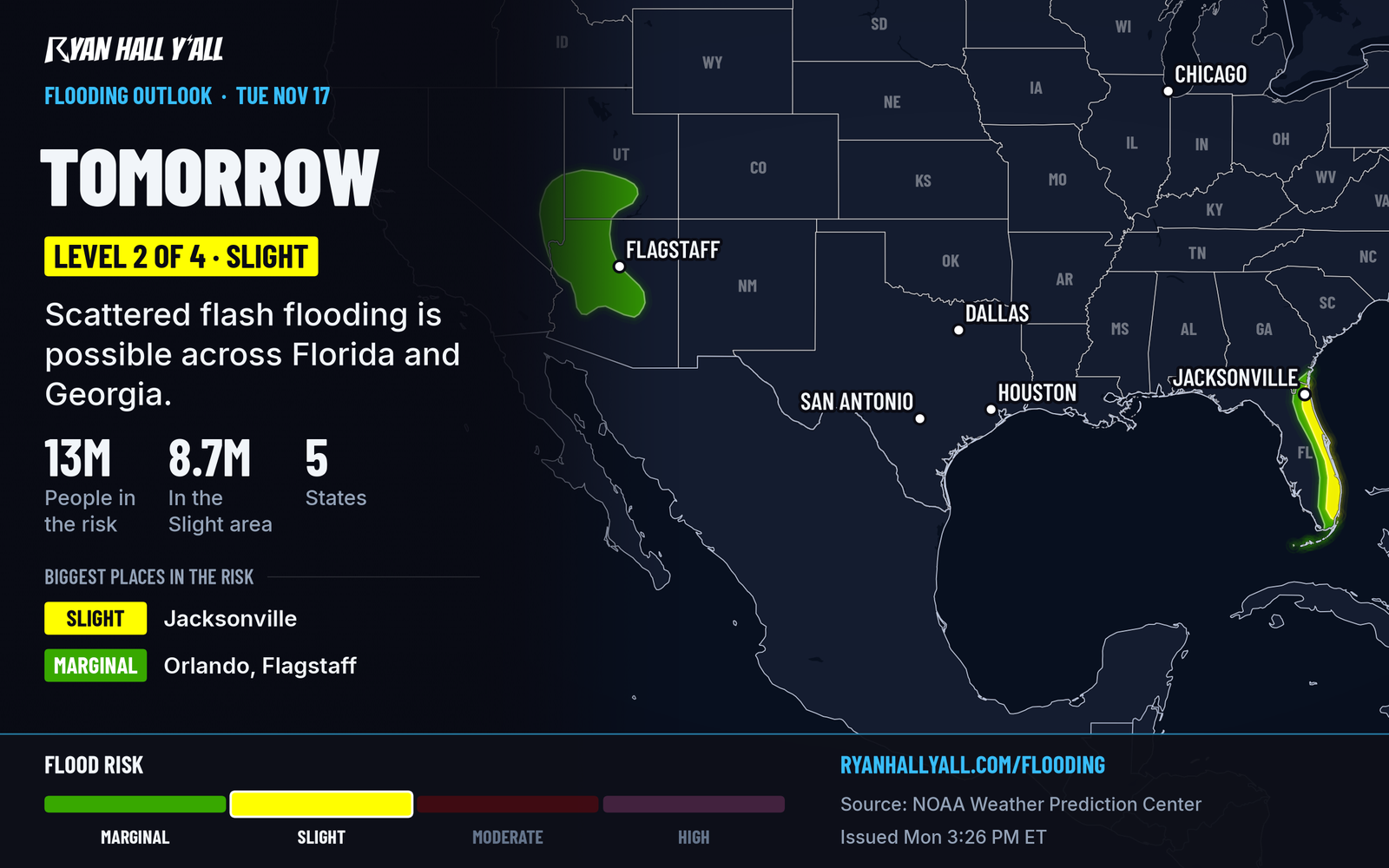
- When: Level 3 runs from 7 AM ET Wednesday to 7 AM ET Thursday. Today, Tuesday, is Level 2 of 4. Thursday, Nov. 19, stays at Level 2 for Florida and Georgia.
- What: Slow, repeating bands of heavy rain, with more than 5 inches possible in the strongest bands.
- What it means: Flash flooding is the danger. No severe storms are expected Tuesday, Wednesday or Thursday.
Florida faces a Level 3 of 4 flash flood risk Wednesday along the Space and Treasure Coasts
Updated 5:30 AM ET Tuesday.
Florida's east coast has a Level 3 of 4 (Moderate) flash flood risk on Wednesday, Nov. 18, centered from Fort Pierce to Melbourne and Titusville (St. Lucie County north to Brevard County). More than 5 inches of rain is possible in the heaviest bands. Rain starts today at Level 2 of 4, so the ground will already be wet when Wednesday's downpours arrive.
Wednesday's heavy rain sets up along the central Florida coast
A disturbance over Florida is slowing down and cutting off from the main flow of the atmosphere. At the ground, a cold front has left an east wind blowing in off the Atlantic. Winds high above are blowing the opposite way, from the west.
That tug of war makes storms form along the coast and then stay put. Picture train cars rolling over the same crossing, one band after another over the same neighborhoods. The air holds plenty of moisture, and there is a moderate amount of storm fuel (1,000 to 2,000 units of CAPE). The setup supports heavy downpours, while no severe storms are expected.
Computer models that show small-scale detail line up on this pattern. In the heaviest bands they show high odds (70 to 90 percent) of more than 5 inches of rain, and moderate odds (40 to 60 percent) of more than 8 inches. Those odds apply to the strongest bands, not to every town on the coast.
Today's Level 2 rain sets the table
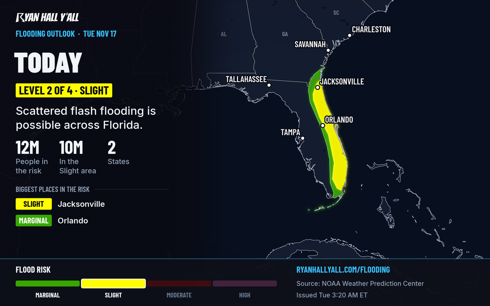
Today, Tuesday, Nov. 17, a Level 2 of 4 (Slight) flash flood risk covers Florida. Locally heavy totals of 3 to 5 inches are possible, with scattered flash flooding. The best chance for 5 inches or more is from South Florida and the Gold Coast north through the Treasure Coast, where storm fuel is highest.
That rain leaves the ground wetter. When Wednesday's heavier rain falls on top of it, more of it runs off into streets and low spots.
How sure we are
The risk level is solid. The Level 3 area was added because the high-resolution models agree on where the bands should anchor. The bands are most likely to set up from central Florida northward, and the Level 3 area may need to be stretched north toward Jacksonville. Even outside the Level 3 area, scattered flash flooding is expected along the whole east coast.
Thursday keeps a Level 2 threat for Florida and Georgia
The disturbance starts to weaken and merge back into the main flow Thursday. Even so, the same east wind and slow storms can still bring locally 3 to 5 inches along Florida's east coast. The models disagree more on where the heaviest rain lands, so Thursday stays at Level 2 of 4 for now. If the same areas get hit twice, it could be raised.
California gets its own round of rain
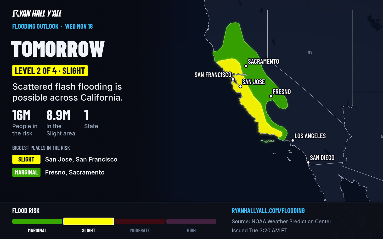
A plume of Pacific moisture (an atmospheric river) moves into northern California and then central California on Wednesday. It is on the weaker side and moves along fairly quickly, but a few thunderstorms could bring heavier bursts. The East Bay interior valleys have a Wind Advisory from 9 PM Tuesday to 1 PM PST Wednesday, with gusts up to 50 mph. Humboldt Interior, Interior Del Norte and Southwestern Humboldt have a Wind Advisory with gusts up to 55 mph from 6 PM Tuesday to 3 AM Wednesday.
On Thursday the moisture moves into southern California. Level 2 of 4 is up for parts of California, with locally 1 to 3 inches along the Transverse Ranges. Burn scars are particular trouble spots for flash flooding.
What to do
- Plan Wednesday's drive now. If you are on I-95 or coastal roads from Fort Pierce to Titusville, move errands out of the heavy rain.
- Never drive through water over the road. Treat any flooded road as closed.
- Clear storm drains and gutters near your home today, and move cars out of low spots and flood-prone parking lots.
- Avoid underpasses and dips in the road when water is rising.
- Check the flash flood outlook and active warnings as the rain starts, and sign up for free Y'all Alerts so a warning reaches your phone.
Bottom line
Wednesday is the main flash flood day for Florida's east coast, with the highest risk from St. Lucie County to Brevard County and more than 5 inches possible in the heaviest bands. Plan your driving around the heavy rain, and expect the threat to linger into Thursday.
Explained: What the flash flood risk levels mean, from Level 1 to Level 4, What a Wind Advisory, High Wind Watch and High Wind Warning mean
More on Southeast flooding, November 2026
Places in this story: Jacksonville, FL
Sources
- WPC Day 2 Excessive Rainfall Outlook, NOAA Weather Prediction Center, issued
- WPC Day 1 Excessive Rainfall Outlook, NOAA Weather Prediction Center, issued
https://ryanhallyall.com/news/florida-level-3-of-4-flash-flood-risk-wednesday-atlantic-coast