Forecasts
Heavy California rain Wednesday, Nov. 18, and up to 3 feet of Sierra snow through Thursday
By Ryan Hall, Y'all Weather Desk · Published
Written by our automated news desk from National Weather Service data.
What's new: The focus shifts from the departing Texas coast rain to western mountain snow today and California's Level 2 of 4 flood risk Wednesday. Florida's Tuesday risk remains Level 2 of 4.

Key points
- Pacific Northwest, Sierra Nevada and northeast Oregon mountains, today: Rain in the lowlands and snow in the mountains. Expect slick, slow driving over the passes.
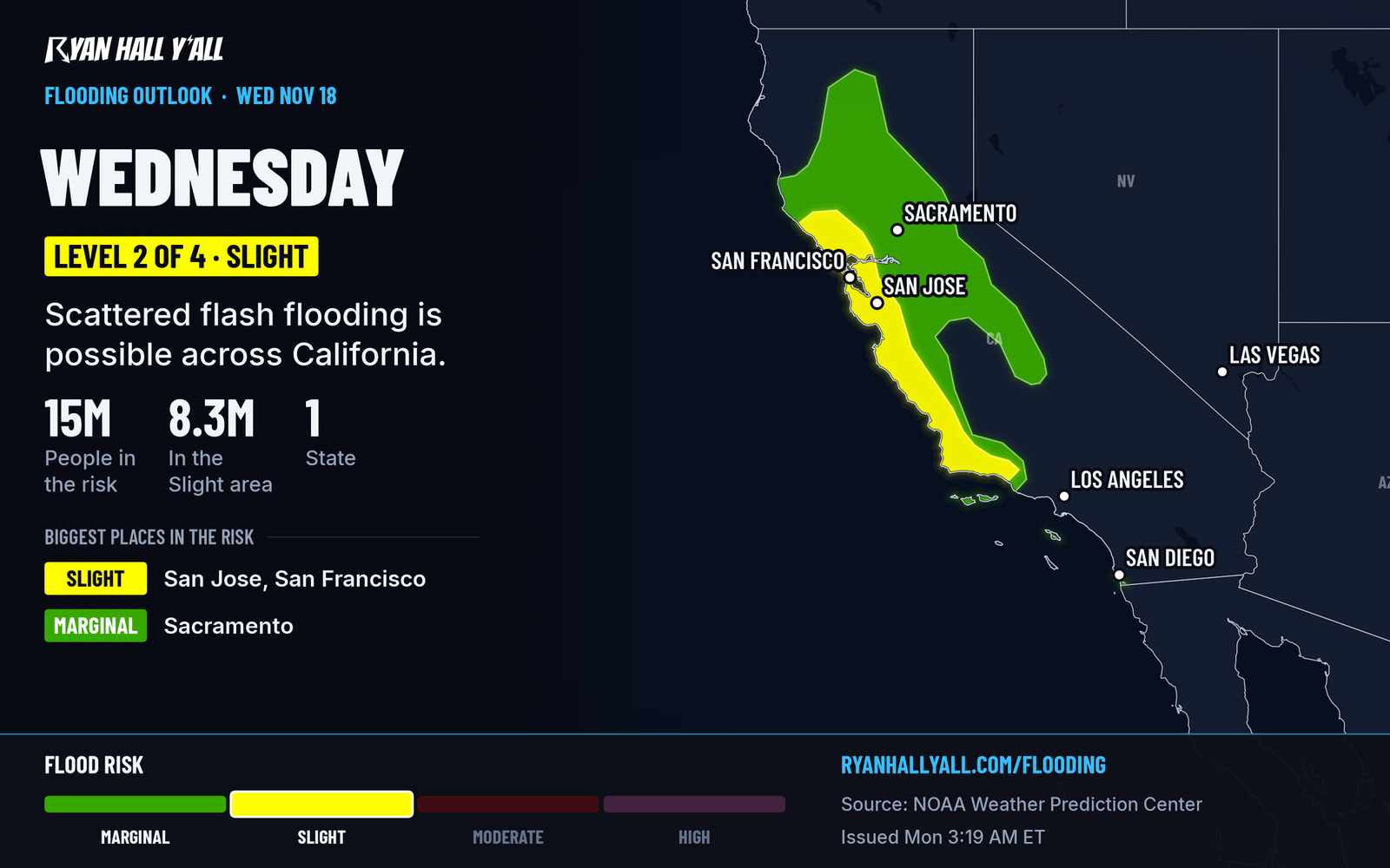
- Central coastal California, Tuesday night into Wednesday, Nov. 18: Heavy rain and strong winds, with a Level 2 of 4 flash flood risk. Allow extra time on the Bay Area and Central Coast commutes.
- Florida's east coast, Tuesday and Wednesday: A multi-day soaking with a Level 2 of 4 flash flood risk. Details are in our earlier Florida story.
- Texas through the Ohio Valley to the Mid-Atlantic, Tuesday: Dry, sunny and cool, about as nice as November gets.
- Northern tier, Tuesday and Wednesday: A minor geomagnetic storm could make the northern lights visible.
A strong Pacific storm is bringing rain and mountain snow to the Pacific Northwest and Sierra Nevada today, Monday, Nov. 16. The heavier part arrives Tuesday night into Wednesday, Nov. 18, when a fresh plume of Pacific moisture, an atmospheric river, brings heavy rain to central coastal California under a Level 2 of 4 (Slight) flash flood risk, while the Sierra Nevada could get up to 3 feet of snow through Thursday night, Nov. 19. Severe storms are not expected anywhere in the lower 48 through Wednesday.
Heavy rain and deep mountain snow build in California by Wednesday
Today is the warm-up act. Our winter storm outlook has a Marginal risk of winter weather impacts in the Sierra Nevada and the northeast Oregon mountains. Tuesday the moisture pushes inland toward the Intermountain West and the northern and central Rockies.
The main event comes Tuesday night into Wednesday. Heavy rain and strong winds arrive along the central California coast, and the Bay Area is included. Snow levels start around 4,000 to 5,000 feet in the coastal ranges. The storm moves along fairly quickly, which should keep rain totals from piling up as badly as they could, but the flash flood outlook still calls for a Level 2 of 4 on Wednesday. Ground in the Bay Area is already wet. Sunday's rain left lanes flooded near Colma and a downed tree on I-280.
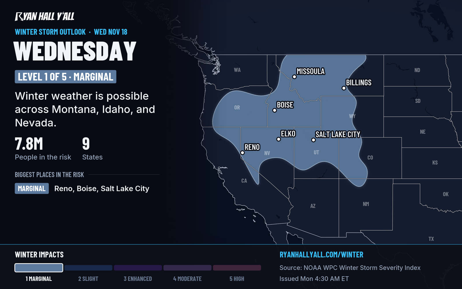
In the mountains, the Sierra gets multiple days of heavy snow, with up to 3 feet possible through Thursday night. Pass conditions at Donner Pass are expected to get bad quickly. Confidence in a big mountain snow event is high. The exact rain totals at the coast are less certain. Don't drive into water over the road. Check Sierra pass conditions before you leave on I-80 or US-50, and think about moving travel up to Tuesday.
The snow then spreads across the Great Basin, Salt Lake City's Wasatch and the Rockies Thursday.
Florida's east coast starts a multi-day soaking Tuesday
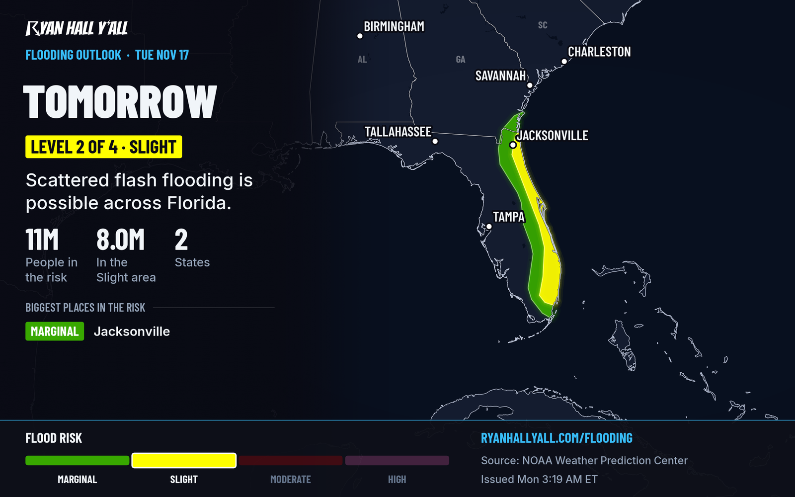
Nothing has changed here since our earlier story. Rain along the Atlantic coast from South Florida to the Georgia line starts Tuesday morning and lasts into Wednesday. It sits at Level 2 of 4 both days. Bands of storms may keep forming over the same spots, with local totals of 3 to 5 inches possible. Low-lying streets and I-95 are the likely trouble. Miami and Fort Lauderdale flights may run late in heavy rain, so check the airport delay outlook before you head out. The St. Johns River near Cocoa is already above flood stage.
One small extra: a Marginal flash flood risk Tuesday covers parts of Arizona, southern Nevada and southern Utah. If you're hiking slot canyons or burn scars, skip them.
Dry, calm weather covers the middle of the country
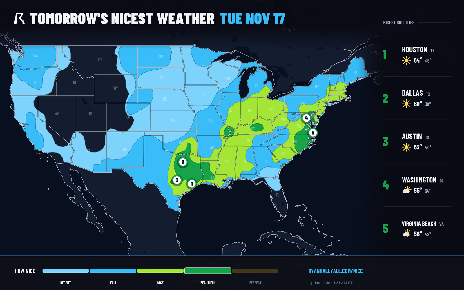
Today's nicest spots include El Paso, Las Cruces, Tucson, Tulsa and Shreveport. It's dry with light winds. Farther north, cloudy skies hold highs in the 50s across the Plains, Midwest and Mid-Atlantic. Tuesday the best weather stretches from Texas through central Kentucky to the Mid-Atlantic and southeastern North Carolina. Afternoons are in the 50s and 60s, and mornings can be frosty. Our Nice Weather outlook has the city rankings.
Space weather is also active. A minor (G1) geomagnetic storm is possible Tuesday and Wednesday, so look north after dark if your skies are clear. The space weather page has more.
Looking ahead
The western system moves east late in the week. By Friday and into the weekend, low pressure could bring snow and gusty winds to the High Plains and the northern tier, with Rapid City in the outlook. Confidence is lower on that part, since the track and timing can still shift. Severe weather looks limited for now, and modest Gulf moisture only starts to return toward the weekend.
Bottom line
If you're traveling in California or over the Sierra Wednesday or Thursday, plan around heavy rain and snow, and leave early or wait it out. Tuesday is a good day to be outside from Texas through central Kentucky to the Mid-Atlantic and southeastern North Carolina.
More on West winter weather, November 2026
Sources
- WPC Day 2 Excessive Rainfall Outlook, NOAA Weather Prediction Center, issued
- WPC Day 3 Excessive Rainfall Outlook, NOAA Weather Prediction Center, issued
- Ryan Hall, Y'all winter storm outlook, day 3 (our own outlook), Ryan Hall, Y'all, issued
- WPC Winter Storm Severity Index (WSSI), NOAA Weather Prediction Center
- Ryan Hall, Y'all Nice Weather outlook (our own outlook), Ryan Hall, Y'all, issued