Forecasts
Florida Level 2 flood risk Tuesday, Sierra snow Wednesday, then a Plains storm
By Ryan Hall, Y'all Weather Desk · Published
Written by our automated news desk from National Weather Service data.
What's new: First look at how the West Coast storm may turn into a Plains and Upper Midwest winter storm by Nov. 20-21, plus a new Level 2 of 4 flood risk for Florida's east coast Tuesday.

Key points
- Wednesday, Nov. 18: Peak day for heavy Sierra snow and heavy rain in California. Mountain passes get hard to cross.
- Tuesday, Nov. 17, into Thursday: Rain along Florida's east coast, from Miami to Cape Canaveral, with the flood risk highest Tuesday night into Wednesday morning.
- Thursday, Nov. 19: Snow spreads across the Great Basin, the Wasatch near Salt Lake City, and the Central Rockies.
- Friday and Saturday, Nov. 20 to 21: A storm may form over the central Plains, with isolated severe storms Friday and snow into the northern High Plains and Upper Midwest. This part is the least certain.
- Monday and Tuesday: Quiet, pleasant weather across Texas and much of the East.
Sierra snow Wednesday, Florida rain Tuesday, then a Plains storm by Friday
Florida's east coast begins a multi-day soaking Tuesday, Nov. 17, under a Level 2 of 4 (Slight) flash flood risk. Heavy mountain snow and rain then hit California and the West from Wednesday, Nov. 18, through Thursday, Nov. 19, with up to 3 feet of snow in the Sierra Nevada before the system moves toward the Plains and Upper Midwest Friday and Saturday, Nov. 20 to 21.
Day by day
- Monday, Nov. 16: Texas dries out behind a front, with no severe or flood risk. Snow continues near Donner Pass on I-80, with more than 6 inches likely. Rain and mountain snow fall in the Northwest.
- Tuesday, Nov. 17: Rain builds along Florida's east coast. Snow moves into the northern and central Rockies. A G1 (Minor) geomagnetic storm is possible.
- Wednesday, Nov. 18: The Sierra snow and California rain peak. Florida's rain continues.
- Thursday, Nov. 19: Heavy snow moves inland to Nevada, Utah and the Central Rockies, including the San Juans. Florida stays wet.
- Friday, Nov. 20: A low develops over the central Plains. Isolated severe storms are possible in the central and southern Plains, and snow reaches parts of Colorado and Wyoming.
- Saturday, Nov. 21: Snow potential spreads into the northern and central High Plains and the Upper Midwest, including western South Dakota.
- Sunday, Nov. 22: Too far out to pin down as forecast confidence decreases late in the period.
A strong Pacific storm buries the Sierra and soaks the coast Wednesday
A deep trough, a big dip in the jet stream, moves into the West. It pulls a stream of Pacific moisture, an atmospheric river, into California. Heavy rain falls along the coast, and the higher terrain takes the snow. Up to 3 feet is likely in the Sierra Nevada from late Tuesday night through Thursday night, with Wednesday the worst day. We covered the numbers in our earlier Sierra story.
On Thursday the snow spreads inland. Widespread accumulating snow is expected across the Great Basin ranges, the Wasatch and the Central Rockies. The main impact is mountain travel.
What to do: if you cross the Sierra on I-80 or US-50, avoid the Wednesday peak if possible and check conditions before leaving. In the Salt Lake City area and the Colorado mountains, plan for slow, snowy passes Thursday. Check our winter storm outlook for updates.
Confidence is high through Thursday. Timing and totals can still shift.
Florida's east coast gets a multi-day soaking starting Tuesday
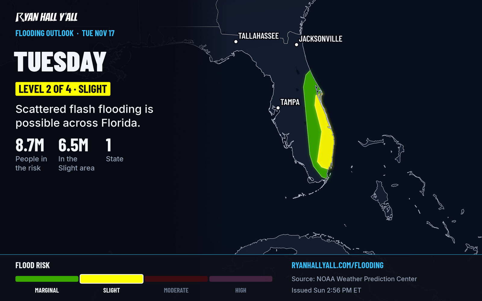
A disturbance crawls across the Florida Peninsula while onshore winds off the Atlantic keep feeding moisture inland. The air will carry about 1.75 to 2 inches of precipitable water, well above normal. The Level 2 of 4 risk covers the Gold Coast, the Treasure Coast and the Space Coast up to Cape Canaveral on Tuesday.
The rain keeps coming for days, so flooding risk grows toward the end of Tuesday and carries into Wednesday. Storms should not be very intense, but the repeated rounds can overwhelm drainage in towns like Fort Lauderdale, West Palm Beach and Melbourne. Don't drive through water over the road Tuesday night, and give yourself extra time Wednesday morning. Our flash flood outlook will update daily.
Confidence is good that it rains. Where the heaviest bands set up is less certain.
A Plains and Upper Midwest storm could take shape Friday and Saturday
As the western system moves east, a low pressure center should strengthen over the central Plains Friday. Warm, humid air from the Gulf returns ahead of it. That could set off scattered storms across the central and southern Plains Friday afternoon and evening, with a few that turn severe. Models disagree on how much moisture and storm fuel will be there, so no risk level exists yet. Watch our severe storm outlooks for the first official call.
On the cold side, snow could spread across the northern and central High Plains and the Upper Midwest Friday into Saturday. Models are still arguing over how fast the system moves east, so treat any snow totals you see online as early guesses. If you have travel plans across Nebraska, the Dakotas or Minnesota this weekend, check back midweek.
Bottom line
Wednesday is the day to plan around in California, the Sierra and Nevada, and Tuesday night into Wednesday matters most in eastern Florida. Everything about the Friday and Saturday Plains storm is still a first draft. Texas and the East get a calm, mild start to the week.
More on Florida flooding, November 2026
Places in this story: Miami, FL; Salt Lake City, UT
Sources
- WPC Day 3 Excessive Rainfall Outlook, NOAA Weather Prediction Center, issued
- Ryan Hall, Y'all winter storm outlook, day 4 (our own outlook), Ryan Hall, Y'all, issued
- WPC Winter Storm Severity Index (WSSI), NOAA Weather Prediction Center