Winter weather
Level 2 winter storm risk for Salt Lake City and Ogden on Friday
By Ryan Hall, Y'all Weather Desk · Published
Written by our automated news desk from National Weather Service data.

Key points
- Where: The Wasatch Range and the Wasatch Front, including Salt Lake City, West Valley City, West Jordan, Sandy and Ogden.
- When: A cold front crosses Utah from Thursday into Thursday night. The Level 2 risk is for Friday, Nov. 20.
- What: Rain turns to snow as snow levels drop from around 6,000 feet to the valley floors overnight. Impacts are rated minor.
- What it means: Hazardous travel conditions are possible during the Thursday evening commute.
A Level 2 of 5 (Slight Risk) winter storm risk covers about 2.8 million people along Utah's Wasatch Range on Friday, including Salt Lake City, Ogden and the Salt Lake Valley. The expected impacts are minor, but snow and slick roads can show up on the valley floors as a cold front crosses the state. This is a travel-slowdown setup, not a major storm, and the best plan is to check the roads before traveling Thursday evening.
Why the Wasatch Front is in Friday's risk
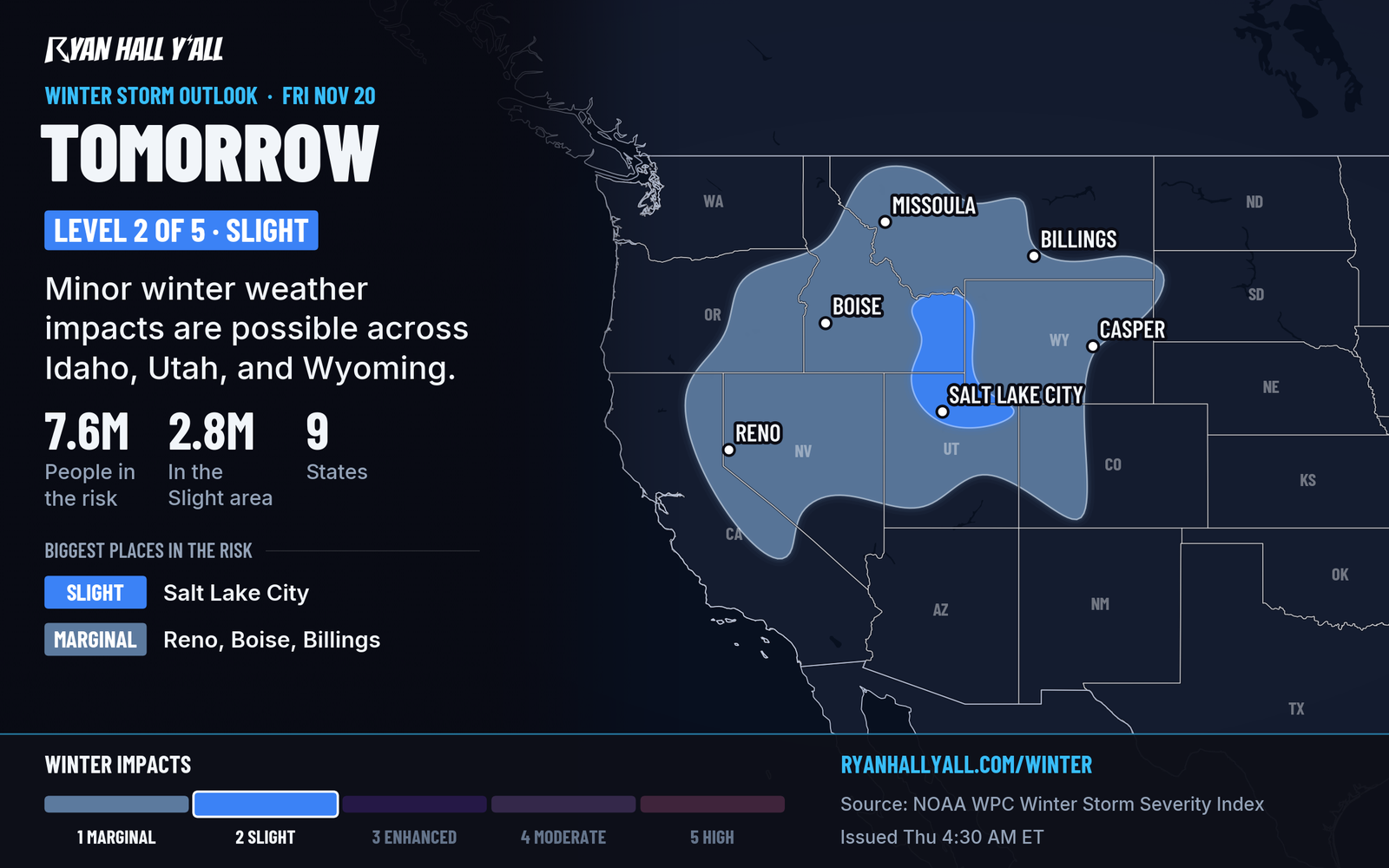
A strong Pacific storm is working its way east across the West. After it pounds the Sierra Nevada, a cold front sweeps across Nevada, southern Idaho and Utah. As colder air arrives, rain over the valleys changes to snow, and the snow level falls from roughly 6,000 feet to the valley floors overnight.
That is why a few million people in the Salt Lake City to Ogden stretch are inside the risk area. The Level 2 rating means there is a Slight Risk of significant winter weather, while about 2.8 million people are within the risk area. Our outlook rates the impacts as minor, and it doesn't give a snow total for the valleys.
What the Sierra storm tells us
The system feeding Utah is already hitting California hard. Winter Storm Warnings for the northern Sierra and the Lake Tahoe area run until 4 AM PST Friday. Totals of 2 to 4 feet are expected above 5,000 feet in the northern Sierra, and 15 to 30 inches above 7,000 feet around Tahoe. Wind gusts around Truckee and Lake Tahoe could reach 30 to 45 mph, with ridgetop gusts as high as 100 mph.
For Utah, the risk is Level 2, with minor impacts expected. Our winter storm outlook shows the full picture across the West.
Timing in Utah
A cold front sweeps across Utah from Thursday afternoon through Thursday night. Snow levels fall from around 6,000 feet to the valley floors overnight, changing rain to snow and creating potentially hazardous conditions for the Thursday evening commute.
Looking ahead, the pattern stays active. Our outlook has a Marginal risk of winter weather across the Intermountain West and central Rockies on Saturday, and more Pacific storms are lined up for the West into next week.
What to do
- Check the interstate driving outlook before heading out Thursday evening, especially if you use I-15 or I-80 or travel through the canyons.
- Leave a little extra time for the Thursday evening commute, when the cold front could create hazardous travel conditions.
- Look at the snow forecasts for the latest totals, and sign up for free Y'all Alerts if you want a heads-up on your phone.
Bottom line
Friday brings a Level 2 winter storm risk to Salt Lake City, Ogden and the rest of the Wasatch Front, with minor impacts expected. The cold front could create hazardous travel conditions during the Thursday evening commute.
Explained: Winter Storm Watch vs. Warning vs. Winter Weather Advisory: What Each Means
More on West winter weather, November 2026
Places in this story: Salt Lake City, UT; West Valley City, UT; West Jordan, UT; Sandy, UT; Ogden, UT
Sources
- Ryan Hall, Y'all winter storm outlook, day 2 (our own outlook), Ryan Hall, Y'all, issued
- WPC Winter Storm Severity Index (WSSI), NOAA Weather Prediction Center
https://ryanhallyall.com/news/level-2-winter-storm-risk-for-salt-lake-city-and-ogden-on-friday