Flooding
Level 3 of 4 Flash Flood Risk for Parts of Eastern and Central Florida Today and Friday
By Ryan Hall, Y'all Weather Desk · Published · Updated
Written by our automated news desk from National Weather Service data.
What's new: Now leads with today's Level 3 risk, adds the South Florida Flood Watch and the 8-inch rain odds for east-central Florida, and drops the model-run graphic.

Key points
- Where: Parts of eastern and central Florida, including the Space Coast and Treasure Coast. A Flood Watch covers the metros of Miami-Dade and especially Broward and Palm Beach counties.
- When: 7 AM ET Thursday to 7 AM ET Friday, then 7 AM ET Friday to 7 AM ET Saturday. Easing late Friday night.
- What: Level 3 of 4 flash flood risk both days, with repeated bands of heavy rain.
- What it means: Streets, underpasses and low spots can flood quickly, and a flood wave is still moving north up the St. Johns River.
- Next: A Level 2 of 4 risk covers parts of the Florida, Georgia and South Carolina coasts on Saturday, Nov. 21.
Parts of eastern and central Florida are under a Level 3 of 4 (Moderate) flash flood risk today, Thursday, Nov. 19, and again on Friday, Nov. 20. Some guidance puts the odds of 8 inches of rain or more at 50% or better across east-central Florida, and rain rates up to 4 inches in an hour are possible in the strongest bands.
The ground is already soaked after recent heavy rain, increasing the flash flood risk. The heaviest rain should ease late Friday night into early Saturday morning.
Today's highest risk covers Cocoa Beach, Melbourne and Fort Pierce
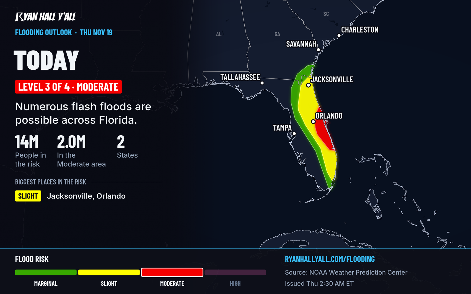
Today's Level 3 includes a higher-end area around Cocoa Beach, Melbourne and Fort Pierce. The air over Florida is carrying a lot of moisture, and the winds are lined up so storm bands can park over one spot for an hour or two before rebuilding somewhere else. In that setup, rain rates up to 4 inches in an hour are theoretically possible. That is enough to overwhelm city drainage.
A Flood Watch is also up through this evening for the metros of Miami-Dade and especially Broward and Palm Beach counties. Check active warnings through the day.
Friday brings another round on the east coast
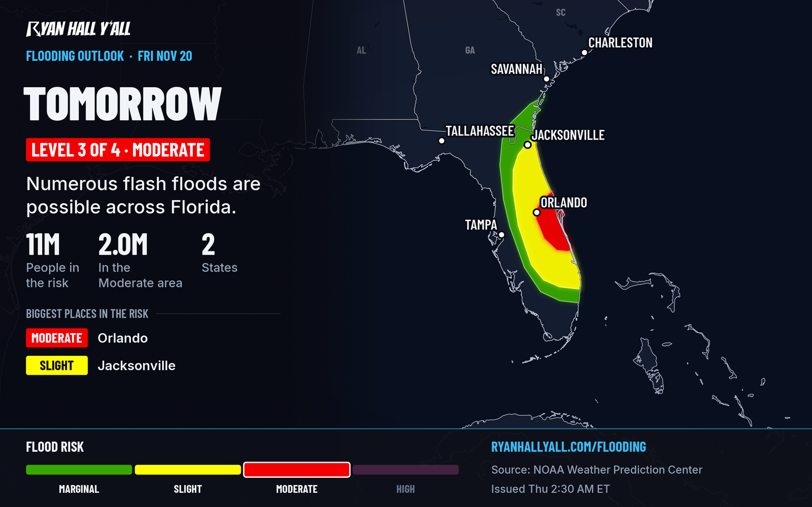
This is a multi-day event, and Friday is not a fresh start. More disturbances cross Florida by Friday and help a low form along a stalled front near the Bahamas. That low draws energy from warm Gulf Stream water and keeps heavy rain going along the east coast. As it moves north, the winds should shift and slowly ease the heavy rain late Friday night into early Saturday morning.
Part of Friday's Level 3 comes from how wet the ground will be by morning, not only from the rain still to fall.
Why the ground can't take much more
Rain totals are already close to the mid-November 2023 event in eastern Florida. Recent rains of 3 to 6 inches soaked east-central Florida and the area near Royal Palm Beach. Some spots between Hollywood and Pembroke Pines in Broward County picked up 12 to 17 inches. A flood wave from heavy rain about two to three weeks ago is still moving north up the St. Johns River.
On top of that, one model group puts the odds of 8 inches or more at 50% or better for east-central Florida. That group tends to run high, so treat 8 inches as the top end, not a promise for every town. The concern is a possible repeat of the heavy rain from a few weeks back.
Saturday's risk reaches Georgia and South Carolina
On Saturday, Nov. 21, a Level 2 of 4 (Slight) flash flood risk covers parts of the Florida, Georgia and South Carolina coasts. The Hurricane Center gives the low a 50% chance of becoming a subtropical or tropical storm. No named storms are active right now, and a name would not change Friday's rain. The soaking comes either way.
The track is still up in the air. A more offshore path would keep the heaviest rain off the coast, and the risk could be trimmed. A path closer to shore would put more rain on land, and coastal flooding could add to the problem in some spots. Follow the tropics page for any change.
What to do
- Don't drive through water over the road. Do not try it at night, when you can't judge the depth.
- Move early. Plan Thursday and Friday trips around the heaviest bands, and check the interstate driving outlook before you go.
- Know your flood spots. If your street or lot flooded in the last few weeks, move cars and valuables to higher ground.
- Get warnings on your phone. Sign up for free Y'all Alerts.
- Check the outlook. Our flash flood outlook updates through the day.
Bottom line
Parts of eastern and central Florida face repeated heavy downpours today and Friday on saturated ground, with flash flooding the main concern. Keep off flooded roads, and watch Saturday for the Georgia and South Carolina coast.
Explained: What the flash flood risk levels mean, from Level 1 to Level 4, Flood Advisory, Watch, Warning and Flash Flood Warning explained
More on Florida flooding, November 2026
Places in this story: Miami, FL; Melbourne, FL; Cocoa Beach, FL; Fort Pierce, FL
Sources
- WPC Day 2 Excessive Rainfall Outlook, NOAA Weather Prediction Center, issued
- WPC Day 1 Excessive Rainfall Outlook, NOAA Weather Prediction Center, issued
https://ryanhallyall.com/news/level-3-of-4-flash-flood-risk-for-eastern-and-central-florida-friday