Forecasts
Nov. 20-22 weekend: Florida flooding Friday, coastal low rides up Southeast coast
By Ryan Hall, Y'all Weather Desk · Published
Written by our automated news desk from National Weather Service data.
What's new: Florida flood risk is now Level 4 of 4 for Friday (the morning edition said Level 3), with a new Level 2 of 4 coastal Southeast risk Saturday and a Level 1 of 5 storm risk on the Plains Saturday.

Key points
- Florida, Friday: More heavy rain from the Space Coast south toward Palm Beach and Broward counties and north toward Jacksonville. It eases Friday night into early Saturday.
- Southeast and mid-Atlantic coast, Saturday into Monday: Rain, wind, high surf and coastal flooding as the low moves north. The track is not locked in.
- Utah and the Rockies, Friday: Heavy snow in the Wasatch and Bear River ranges, 1 to 2 feet, locally 25 to 30 inches.
- Southern Plains, Saturday: A Level 1 of 5 (Marginal) storm risk across Oklahoma, Kansas and Texas, mainly late afternoon and evening.
- Best weather: Dry and sunny Saturday from the Ohio Valley through Tennessee, with a nice Friday in Middle Tennessee and north-central Texas.
Parts of eastern Florida stay under a Level 4 of 4 (High) flash flood risk on Friday, Nov. 20, with another 1 to 3 inches of rain possible, locally more, on ground that cannot take any more. A coastal low then forms east of Florida and moves up the Southeast coast Saturday and Sunday, with a Level 2 of 4 (Slight) flood risk for coastal Georgia, South Carolina and Florida on Saturday. The Hurricane Center gives it a 30% chance of becoming a subtropical or tropical storm within 48 hours and 60% within 7 days. Strong winds, dangerous surf and coastal flooding are likely along the Southeast and mid-Atlantic coasts either way.
Friday night
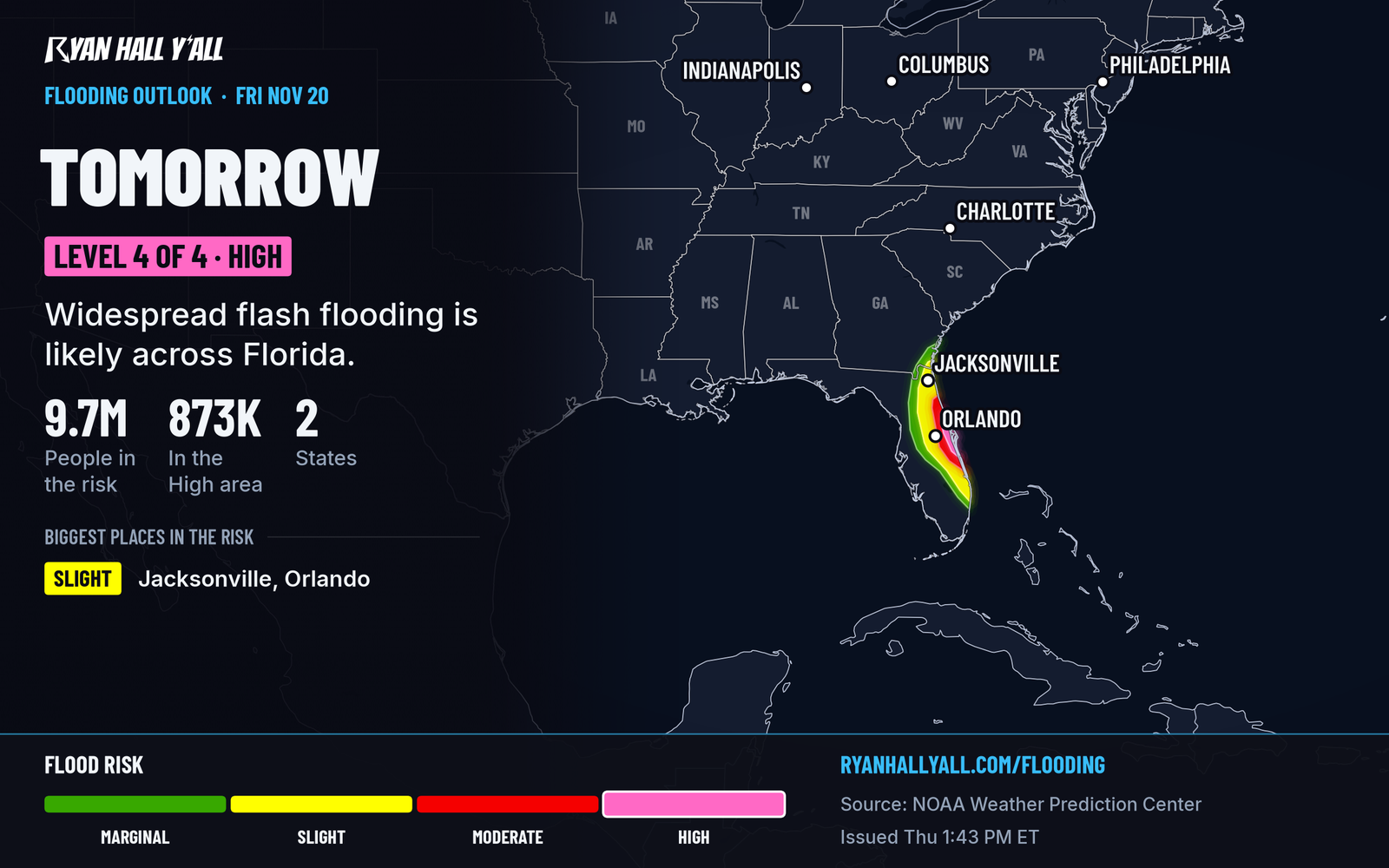
Florida is the main story. Rivers are high, drains are full and the ground is soaked, so even moderate rain causes new flooding. The St. Johns River near Cocoa is already at a record. Our Florida flood coverage has the details. Don't drive into water over the road, and plan Friday night trips around the rain bands. Rain should ease late Friday night as the low pulls away from the state.
In the West, a Canadian cold front drives snow into Utah. In Salt Lake City, snow starts Friday afternoon and gets going by Friday evening. Snow levels fall below 4,500 feet behind the front. Expect 1 to 3 inches on the benches and up to an inch on the valley floors. Mountain roads get slick fast. Check the interstate outlook before heading out on I-15 or I-80.
On the High Plains, gusts over 35 mph are possible Friday. Winds of 15 to 25 mph and dry air raise the fire danger across central Colorado, southeast Wyoming and far western Nebraska.
Saturday
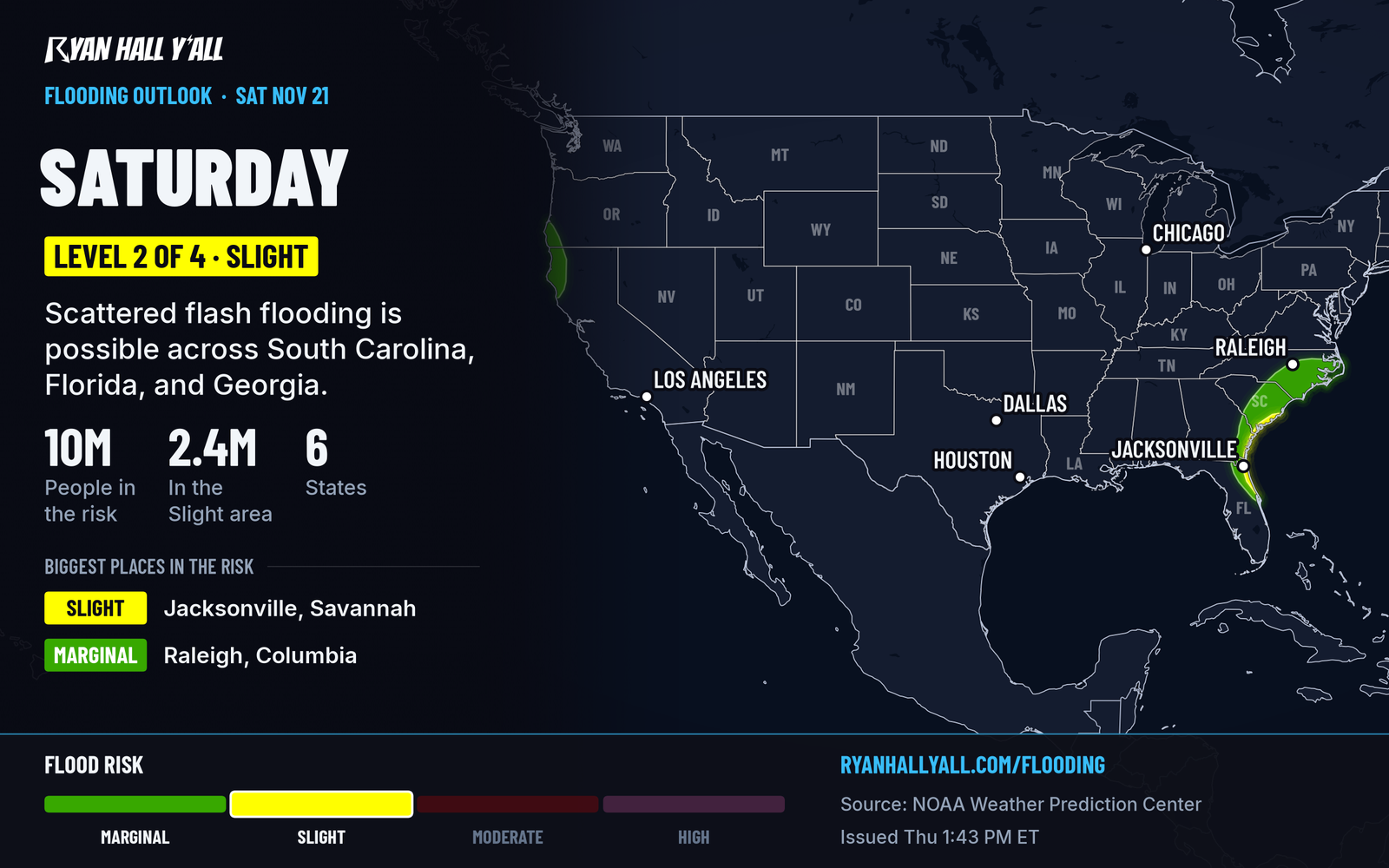
The coastal low moves north roughly parallel to the Southeast coast Saturday and Saturday night. Heavy rain is possible along the coast of Georgia, South Carolina and Florida. Surf, wind and coastal flooding build from Florida toward the Carolinas. The Outer Banks can get thunderstorms too. Guidance leans toward a track just offshore, which would keep the worst rain at the beaches. A closer track would pull heavier rain inland. Plan around both for now, and check flash flood outlooks Saturday morning.
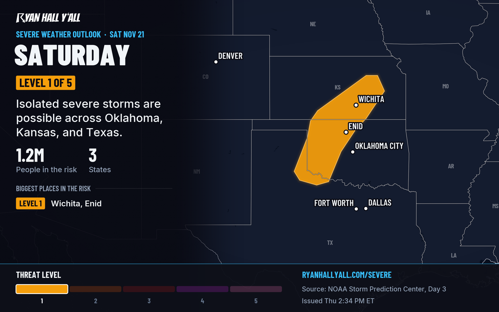
Out on the Southern Plains, a disturbance arrives late Saturday afternoon and early evening Central. Storms are most likely from the southern High Plains into south-central Kansas, including the Wichita and Enid areas. Isolated hail and damaging wind are the concern, but the setup is marginal. Timing has slipped later, so cooler air and thin moisture may hold storms back. Keep an eye on the sky at tailgates and evening games. The severe outlook will update.
Snow continues in the northern and central Rockies through early Saturday morning. Saturday highs in the Central Plains and Midwest hold in the upper 50s to low 60s.
Sunday
A cold front crosses the mid and lower Mississippi Valley. It can set off scattered thunderstorms across east Texas, southern Arkansas and Louisiana, with only a low-end chance of severe storms. Along the East Coast, the low is expected to skirt the Mid-Atlantic coast into Monday, with rain, wind and high surf. It may bring airport delays at Northeast hubs early in the week. Details here are still shifting, so recheck Saturday night.
Light snow reaches the northern Great Lakes and central Rockies. Another Pacific storm follows, bringing heavy mountain snow to the Cascades, Sierra and Intermountain West by Tuesday and Wednesday, plus heavier rain in California.
Best bets
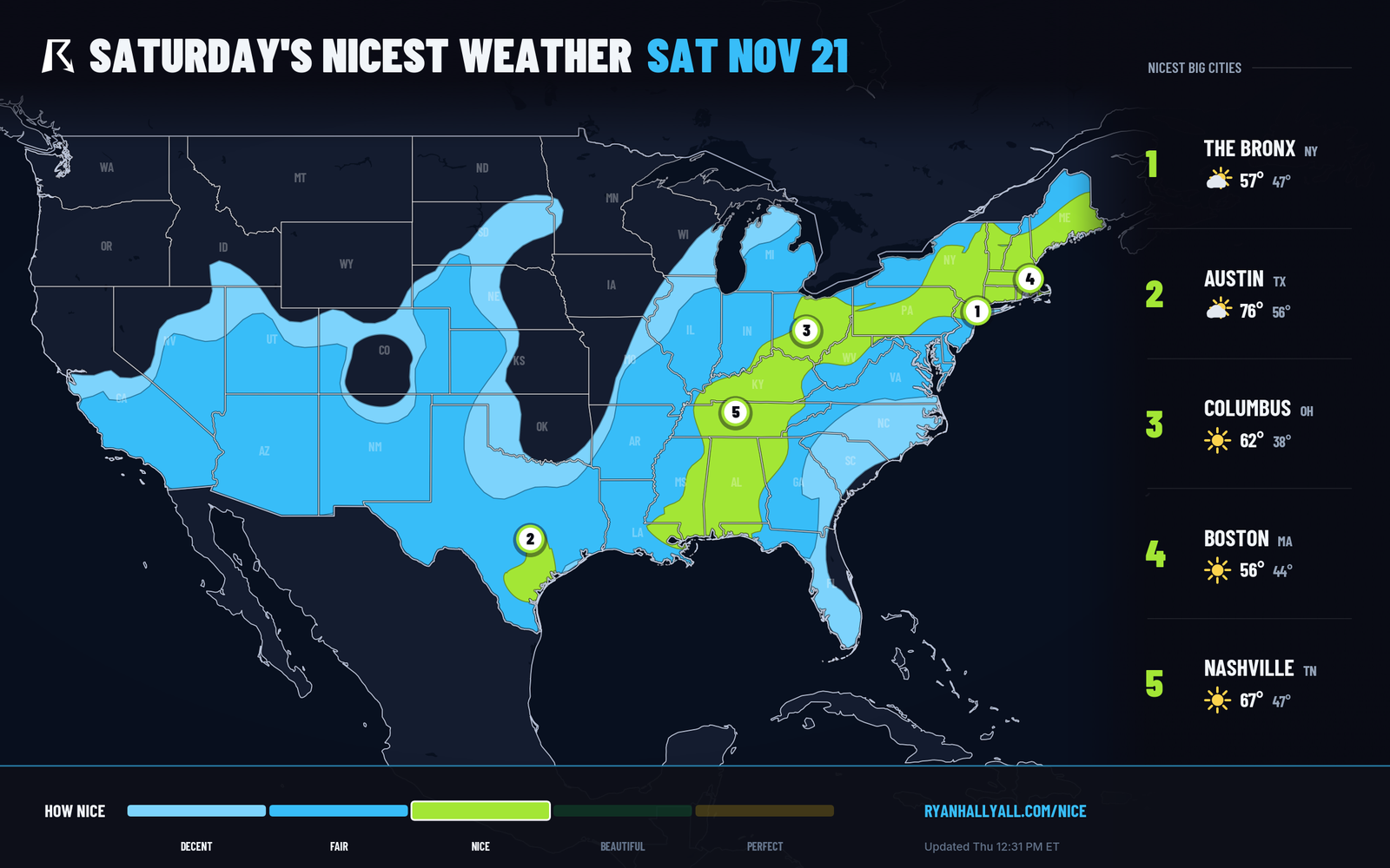
- Ohio Valley, Tennessee Valley and the Gulf South, Saturday: A dry, sunny ridge, light winds of about 8 mph, only about 20% cloud cover and dry, comfortable air. Good for hikes, yard work and football weather. Check the Nice Weather outlook.
- Middle Tennessee and north-central Texas, Friday: The top-tier day for sunny skies, light wind and low humidity.
- Southeast Arizona, Friday and Sunday: Clear, dry and comfortable both days.
- Texas Hill Country, Saturday: Pockets of nice weather for a festival or a day outside.
Bottom line
Florida's flood threat remains high Friday, then the coastal low carries rain, wind and surf up the coast. Dry, mild weather covers the Tennessee and Ohio valleys. Day 3 and 4 details, especially the low's track, can still shift.
More on Florida flooding, November 2026
Places in this story: Jacksonville, FL
Sources
- SPC Day 3 Convective Outlook, NOAA Storm Prediction Center, issued
- WPC Day 2 Excessive Rainfall Outlook, NOAA Weather Prediction Center, issued
- WPC Day 3 Excessive Rainfall Outlook, NOAA Weather Prediction Center, issued
- Ryan Hall, Y'all Nice Weather outlook (our own outlook), Ryan Hall, Y'all, issued