Winter weather
Up to 30 more inches of snow in the Sierra above 7,000 ft; I-80 near Donner Pass white Thursday morning
By Ryan Hall, Y'all Weather Desk · Published
Written by our automated news desk from National Weather Service data.
Key points
- Where: The Sierra Nevada from Donner Pass and Truckee to Lake Tahoe and Echo Summit, spreading east into western Nevada.
- When: Heavy snow all day Thursday, Nov. 19, easing to scattered snow showers after about 10 PM PST. Winter Storm Warnings run until 4 AM PST Friday.
- What: 15 to 30 inches more above 7,000 feet and 8 to 14 inches at lake level around Tahoe. Ridgetop gusts reach 100 mph.
- What it means: Chains are required on I-80 from Gold Run to the Nevada line, and the avalanche danger in the backcountry is rated High.
Up to 30 more inches of snow in the Sierra above 7,000 feet, and I-80 at Donner Pass is white
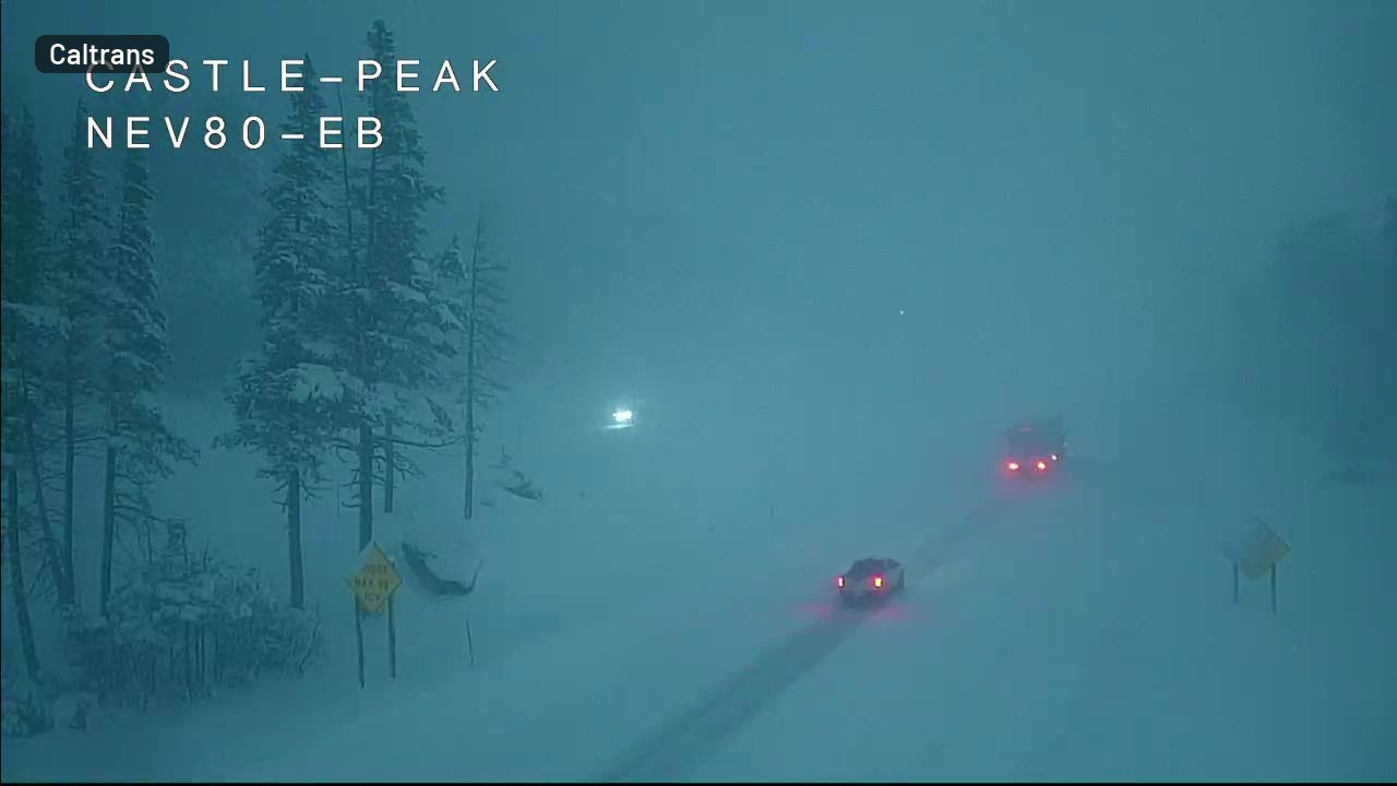
Up to 30 more inches of snow is coming to the Lake Tahoe area above 7,000 feet through 4 AM PST Friday, Nov. 20. Interstate 80 over Donner Pass was already white and nearly blind Thursday morning, with a pickup and a truck fading out of sight within seconds on a Caltrans camera. Plan on dangerous to impossible mountain travel on I-80 and US-50 until the heavy snow tapers late tonight.
I-80 at Donner Pass is already near-whiteout
The Caltrans camera at Castle Peak, about 2 miles west of Donner Summit, showed a white road and heavy snow at 6:37 AM PST. Video credit: Caltrans. Caltrans also closed westbound I-80 to all tractor-semitrailers at the Nevada line because of spinouts, and chains are required from Gold Run to the state line.
Our outlook has snowfall rates of 1 to 3 inches an hour on the Sierra Crest, and locally 3 to 4 inches an hour in heavier bands. At that pace, visibility can drop near zero. Wind gusts of 35 to 50 mph in the valleys will blow the snow sideways.
How much snow, and where
The numbers change with elevation, so here is how it breaks down:
- Greater Lake Tahoe area: 15 to 30 inches more above 7,000 feet and 8 to 14 inches around lake level. Gusts of 30 to 45 mph in Truckee and the Tahoe communities. Waves of 2 to 4 feet on the lake.
- Northern Sierra above 4,000 feet, including I-80, US-50 and Highways 4 and 108: 8 to 12 inches more, up to 18 on the highest peaks.
- Eastern Sierra, Lassen and eastern Plumas counties above 5,500 feet: 4 to 10 inches, locally up to 20 inches west of US-395.
Our winter storm outlook puts storm totals above 5,000 feet at 2 to 4 feet, with up to 5 feet on the highest peaks. It has Donner Pass and Echo Summit at 3 to 4 feet, and Mammoth Lakes at 3 to 4 feet.
Snow levels sit around 4,000 to 5,500 feet this afternoon. They fall to 3,000 to 3,500 feet tonight behind a cold front, so lower foothill roads can turn slick after dark.
Reno, Carson City and the Great Basin
The heavy snow moves east this afternoon and evening. The Tahoe Basin should get 1 to 2 feet, and the US-395 corridor in Mono County 6 to 12 inches. The Sierra Front, including Reno and Carson City, looks like 1 to 4 inches. That is far less than the mountains, but enough to slow the evening commute.
The storm then moves on to Utah. Friday, Nov. 20, our outlook has 12 to 24 inches across the Wasatch and Bear River ranges, with localized amounts above 25 to 30 inches. Valley floors around Salt Lake City get up to 1 inch Friday night, and the Wasatch benches up to 3 inches.
Avalanche danger is High
The Sierra Avalanche Center has a Backcountry Avalanche Warning with a High danger rating from 5:30 AM PST Thursday to 4 AM PST Friday. The warning coincides with heavy new snow and ridgetop gusts as high as 100 mph. Stay out of avalanche terrain until this storm is over and the danger rating comes down.
What to do
- If you don't have to cross the Sierra today, don't. Delay until Friday morning, then check our interstate driving outlook and Caltrans before you leave.
- If you must go, carry chains, a full tank, water, blankets and a charged phone. Expect long stops and spinouts.
- Truckers should check whether the westbound semi closure at the Nevada line remains in place before leaving.
- Skiers and backcountry travelers should avoid avalanche terrain while the High danger rating remains in effect.
- Watch every active warning and see the winter storm outlook for the next round. Another Pacific storm is lined up for the West Coast Tuesday, Nov. 24, and Wednesday. It should bring more heavy mountain snow to the Sierra and Cascades. You can also sign up for free Y'all Alerts.
The warnings remain in effect, and heavy snow is expected through tonight. The exact totals at any one pass depend on where the heaviest bands set up, so amounts can vary from one spot to the next.
Bottom line
I-80 over Donner Pass will be a mess through tonight, with up to 30 more inches in the Tahoe high country and gusts to 100 mph on the ridges. Skip the drive if you can, and if you can't, bring chains and patience.
More on West winter weather, November 2026
Places in this story: Reno, NV
Sources
- 11/19/2026 (recorded 9:37-9:38 AM ET from, National Weather Service