Space weather
Up to 8 inches of rain for Florida's Space Coast by Friday, Wednesday worst
By Ryan Hall, Y'all Weather Desk · Published
Written by our automated news desk from National Weather Service data.

Key points
- Where: The Treasure and Space Coasts, from St. Lucie County north through Brevard County. The Flood Watch reaches inland to Orlando and Orange, Osceola, Seminole and Volusia counties, and south to Martin and Okeechobee counties.
- When: The Flood Watch begins Tuesday afternoon. Wednesday is the peak flood day. The Flood Watch runs through Friday evening.
- How much: Our rain forecast shows about 8 inches from Tuesday through Friday at Cocoa Beach and Melbourne Beach, with 8.1 to 8.3 inches in the latest numbers.
- What it means: Flash flooding is possible, including in neighborhoods.
Up to 8 inches of rain is headed for Florida's Space Coast from Tuesday through Friday, Nov. 20, and Wednesday, Nov. 18 is the worst day. Melbourne, Cocoa Beach and Titusville sit inside a Level 3 of 4 (Moderate Risk) flash flood area that stretches along the Treasure and Space Coasts from St. Lucie County north to Brevard County. A Flood Watch covers most of east central Florida through Friday evening.
Wednesday is the peak flood day
The Level 3 of 4 risk is in effect from 7 AM Eastern Wednesday to 7 AM Thursday. That is the day to take seriously. Today, Tuesday, Florida sits under a Level 2 of 4 (Slight) risk. Thursday drops back to Level 2 of 4 for Florida.
The pattern is a multi-day soaker, not one quick downpour. Wednesday carries the highest flash flood risk of the period.
Where the heaviest rain lands
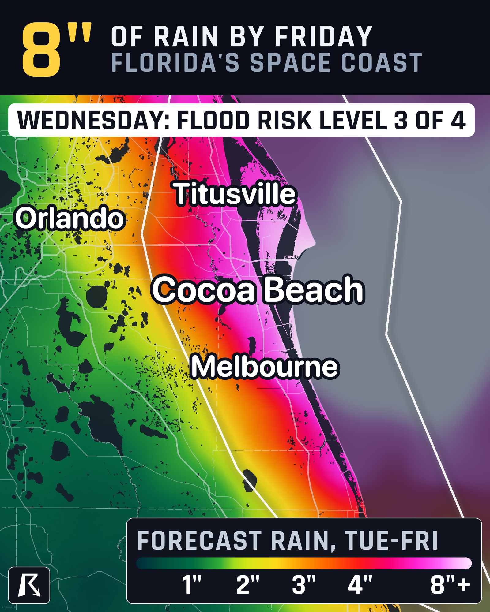
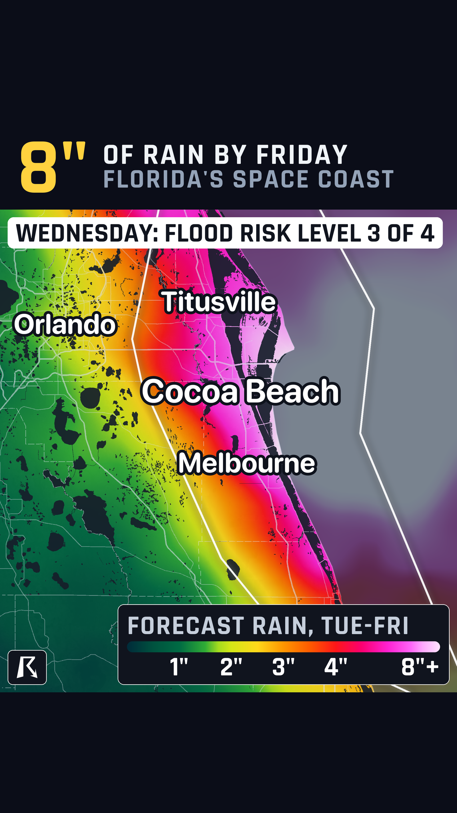
Forecast totals reach 8.1 to 8.3 inches at Cocoa Beach and Melbourne Beach. Titusville is in the same risk area. The Level 3 risk extends south through Vero Beach and Fort Pierce on the Treasure Coast.
The Flood Watch for most of east central Florida covers Volusia, Seminole, Orange, Osceola, Okeechobee, Brevard, Indian River, St. Lucie and Martin counties. It runs from Tuesday afternoon through Friday evening. That puts the Orlando area inside the watch.
Farther south, a separate Flood Watch covers parts of Palm Beach, Broward and Miami-Dade counties. It started at 1 PM Eastern today and runs through Thursday evening. Flash flooding is possible there as well.
How sure we are
The wet pattern and the Wednesday peak are well supported, and the watches are already posted. Treat 8 inches as the high end for the coast, not a promise for every street.
What to do
- Plan Wednesday's driving ahead of time. If you commute along the Space Coast or Treasure Coast, leave extra time. Don't drive into water over the road. It is hard to tell how deep it is.
- Know your low spots. If your street, garage or driveway floods in heavy rain, move cars and valuables to higher ground Tuesday night.
- Clear drains. Clear leaves and debris from storm drains and gutters near your home before the heavier rain arrives.
- Check the live pages. Our flash flood outlook updates through the event, and every active warning is listed live.
- Get alerts. Sign up for free Y'all Alerts so a warning reaches you when you are not watching the sky.
Bottom line
Wednesday, Nov. 18 is the worst day for flash flooding on Florida's Space Coast, with up to 8 inches of rain possible by Friday and a Level 3 of 4 risk from St. Lucie County to Brevard County. Plan Wednesday's travel around it, and keep the Flood Watch in mind through Friday evening.
Explained: Flood Advisory, Watch, Warning and Flash Flood Warning explained
More on Northern lights 2026
Places in this story: Orlando, FL; Miami, FL; Melbourne, FL; Cocoa Beach, FL; Titusville, FL
Sources
- WPC Excessive Rainfall Outlook, NOAA Weather Prediction Center