Forecasts
Flash flood risk for South Texas today, 2 to 3 inches of rain, locally more
By Ryan Hall, Y'all Weather Desk · Published
Written by our automated news desk from National Weather Service data.
Heavy rain from the Rio Grande Valley to the Hill Country carries a Level 2 of 4 flash flood risk through early Monday, with 2 to 3 inches likely and some spots seeing 4 to 6. Rain lingers Monday morning south of I-10 before drying out in the afternoon. Elsewhere it is a quiet Sunday, with a frosty start in the Ohio Valley, a chance of northern lights tonight, and Tropical Storm Pena staying far south of Hawaii.
Key points
- South Texas, all day into Monday morning: 2 to 3 inches of rain is likely, with local totals of 4 to 6 inches. Water over roads is the main danger, especially at low-water crossings and in urban areas.
- South of I-10 on Monday: Rain lingers through the morning and early afternoon. Another half inch to 1 inch is likely, with a few spots getting 2 to 4 on ground that is already soaked.
- Pacific Northwest, next few days: Showers and gusty winds come and go, with snow in the highest Cascades above about 5,000 feet.
- Ohio Valley to the Mid-South, this morning: Frost and freezing temperatures linger early, then it warms up to seasonable or mild afternoons.
- Tonight, northern tier and beyond: Northern lights are possible with a Kp 5 geomagnetic storm in the outlook.
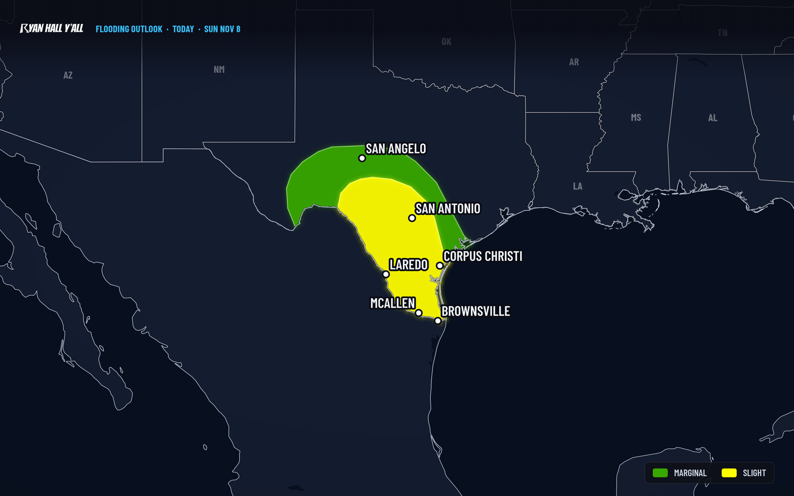
South Texas is the main weather trouble spot today. Rounds of heavy showers and thunderstorms from the Rio Grande Valley up through the Hill Country carry a Level 2 of 4 (Slight) flash flood risk from 6 AM Central Sunday until 6 AM Monday. Most of the rest of the lower 48 is quiet, with a few cold mornings and some real beauty on the East Coast.
Heavy rain keeps training over South Texas through Monday morning
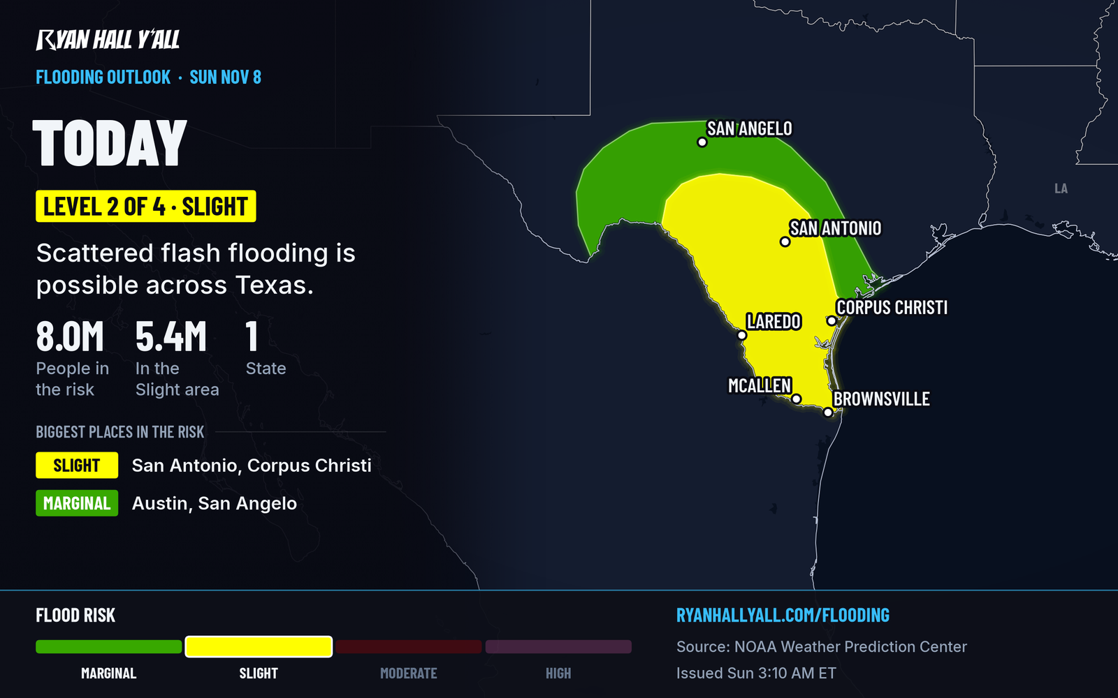
A compact disturbance positioned over northern Mexico is feeding clusters of storms from the Rio Grande Valley northeast across central Texas. Gulf moisture keeps flowing in underneath it, so storms can repeat over the same neighborhoods. That is how 2 to 3 inches turns into 4 to 6 in a few spots. A Flood Watch is up for portions of South Texas.
The highest-risk zone covers the Rio Grande Valley, the Coastal Bend around Corpus Christi, and the Texas Hill Country, including the San Antonio area. Rain is already going this morning. Expect the heaviest bursts through the day and tonight.
What to do:
- Don't drive into water over the road, day or night.
- If you commute on I-37 or I-35 through San Antonio, give yourself extra time and expect ponding.
- Low spots, underpasses and creek crossings are where trouble starts first.
- Air travelers through San Antonio and Austin could see delays. Check the airport delay outlook before leaving.
How sure are we? The risk level and the general area are solid. Exactly which neighborhoods get the 4 to 6 inch totals is not something anyone can pin down yet. Storms will decide that.
Rain eases Monday, but not all at once
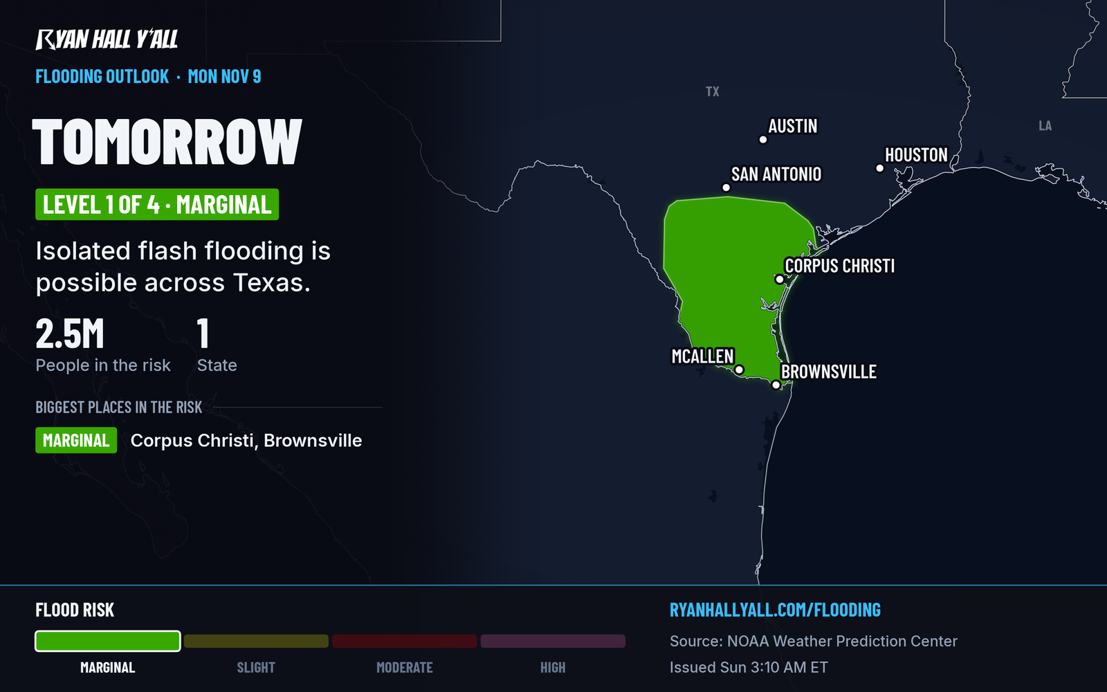
On Monday the disturbance weakens and the winds turn east to northeast. Showers and a few thunderstorms stick around south and southeast of I-10, including the lower Rio Grande Valley, the Coastal Bend and the southern Texas coast. Level 1 of 4 (Marginal) is the flood risk for that day. Coverage drops off sharply after about noon Central, and Tuesday has no flash flood risk outlined. Watch for streams still running high from Sunday's rain, even after skies dry out. See our flash flood outlook for updates.
Pacific Northwest stays wet and breezy
Another round of showers and gusty winds moves through Washington and Oregon over the next few days. Higher Cascade passes pick up snow above about 5,000 feet, and Washington Pass has a 10 to 20 percent chance of at least 4 inches from late Monday into Tuesday before milder air turns it to rain by Tuesday afternoon. Pack for wet roads and check pass conditions if you are crossing the mountains.
Northern lights chance tonight
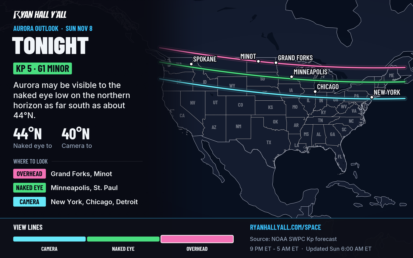
Gusty solar wind from a coronal hole has pushed the geomagnetic field to minor storm level. G1 is expected today, with a chance of G2 into Monday. Our outlook shows Kp 5 tonight, with cameras able to pick up the glow as far south as about 40 degrees north latitude from 9 PM to 5 AM Eastern. Get away from city lights and look north. Our space weather page has the latest.
Tropical Storm Pena stays far from land
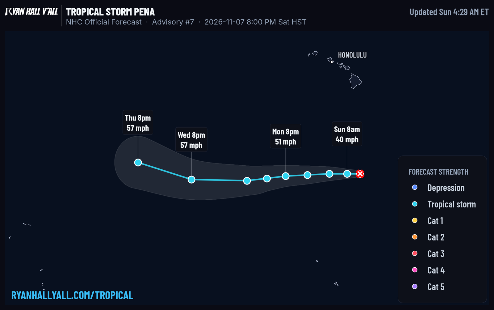
Pena has 45 mph winds and sits about 520 miles south of the Big Island of Hawaii, moving west at 7 mph. Satellite data shows it getting weaker and more ragged, and no watches or warnings are in effect. The forecast keeps it far south of Hawaii, with no landfall forecast. Track it on our Pena page.
Looking ahead
Texas has no flash flood risk outlined Tuesday. By midweek a ridge builds from the southern Plains toward central Canada, bringing above-normal temperatures there, while storms are possible Wednesday across the southern Great Lakes and Ohio Valley. The Pacific Northwest stays unsettled all week with more rain and mountain snow. An East Coast storm is possible late in the week, but that is far enough out that details will change.
Bottom line
If you are in South Texas, plan for flooded roads today and tonight, and stay out of water covering the pavement. Most other places have a relatively quiet Sunday. Norfolk, Richmond and Williamsburg get a Perfect day on our Nice Weather outlook.
More on South Texas flooding, November 2026
Sources
- WPC Day 1 Excessive Rainfall Outlook, NOAA Weather Prediction Center
- WPC Day 2 Excessive Rainfall Outlook, NOAA Weather Prediction Center
- Ryan Hall, Y'all northern lights outlook (our own outlook), Ryan Hall, Y'all
- NHC advisories, NOAA National Hurricane Center