Forecasts
Florida flood risk rises to Level 3 Thursday; Sierra snow Wednesday
By Ryan Hall, Y'all Weather Desk · Published
Written by our automated news desk from National Weather Service data.
What's new: Thursday's Florida flood risk now shows Level 3 of 4 on our maps, California gets a Slight flash flood risk Wednesday, and winter advisories are up for Utah and Montana.
Key points
- Northern California, Wednesday: Heavy rain starts Wednesday morning Pacific time and covers the Bay Area, Sacramento Valley and central coast. Expect slow, wet commutes and a chance of urban flooding and mudslides.
- Sierra Nevada, midday through Wednesday afternoon: Snow falls at 1 to 2 inches an hour above 5,000 feet, with ridge gusts near 100 mph. The interstate outlook shows Hazardous Conditions on portions of I-80 and I-5 Wednesday, so be ready for hazardous to impossible mountain travel.
- Florida east coast, Wednesday and Thursday: Storm bands park over the coast from St. Lucie County north through the Space Coast. Don't drive through water over the road, and know where you can park high.
- Utah and Montana, tonight into Wednesday morning: Winter Weather Advisories run until 11 AM MST Wednesday for the Wasatch, and for central, north central and southwest Montana.
- Tonight into Wednesday: Active to isolated G1 (Minor) geomagnetic storm levels are likely.
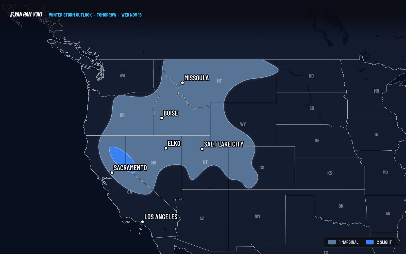
Florida's east coast now has a Level 3 of 4 flood risk Thursday, Nov. 19, matching Wednesday's risk. A strong Pacific storm moves into Northern California Wednesday morning, Nov. 18, with heavy rain from the North Coast through the Bay Area and Sacramento Valley, plus 1 to 3 feet of snow above 5,000 feet in the Sierra and 3 to 4 feet along the crest. Travel over the passes will be hazardous to impossible.
Heavy snow and rain hit California Wednesday
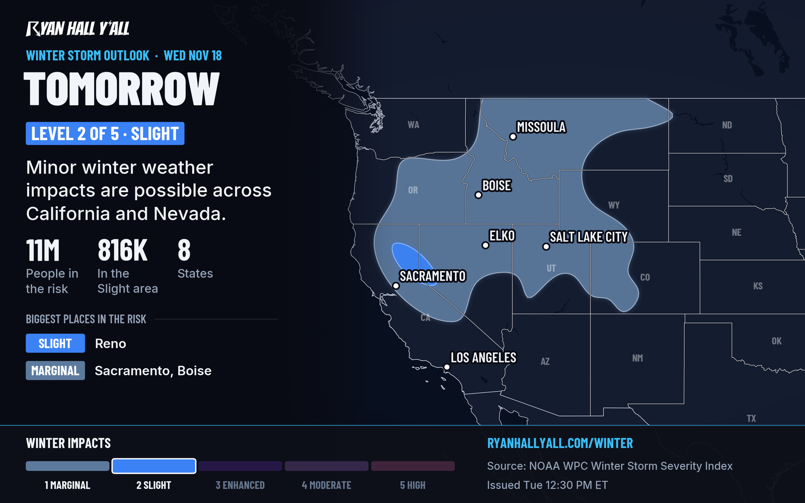
Our winter storm outlook has a Slight risk of significant winter weather impacts for the Sierra Nevada and Northern California on Wednesday. The deep Pacific trough pushes in Wednesday morning, and the heaviest snow comes from midday through the afternoon. Above 5,000 feet, expect 1 to 3 feet. Along the Sierra Crest, expect 3 to 4 feet, with local totals of 4 to 6 feet above 8,000 feet in the central and southern Sierra. Snow levels sit around 3,500 to 4,500 feet in far Northern California. That puts 3 to 8 inches in Mount Shasta City and more than a foot above 4,000 feet along Highway 89 passes.
Ridge gusts near 100 mph will blow the snow around and cut visibility. Our interstate outlook has I-5 and I-80 at Hazardous Conditions for Wednesday. If you have to travel on either route, carry chains and a full tank, and be ready for delays if a pass closes.
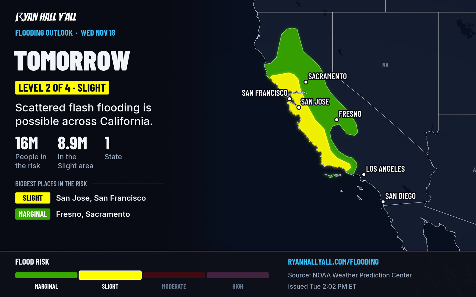
Down in the valleys and along the coast, the story is rain. California has a Level 2 of 4 (Slight) flash flood risk Wednesday. Watch burn scars and steep hillsides for debris flows. Leave extra time for the morning drive. This storm keeps going into Thursday, and our earlier post covers Thursday's rain in Los Angeles. The exact rain totals by city will shift with the storm's track, while the outlook still calls for heavy Sierra snow and strong ridge winds.
Florida's flood risk holds Wednesday and now extends to Thursday
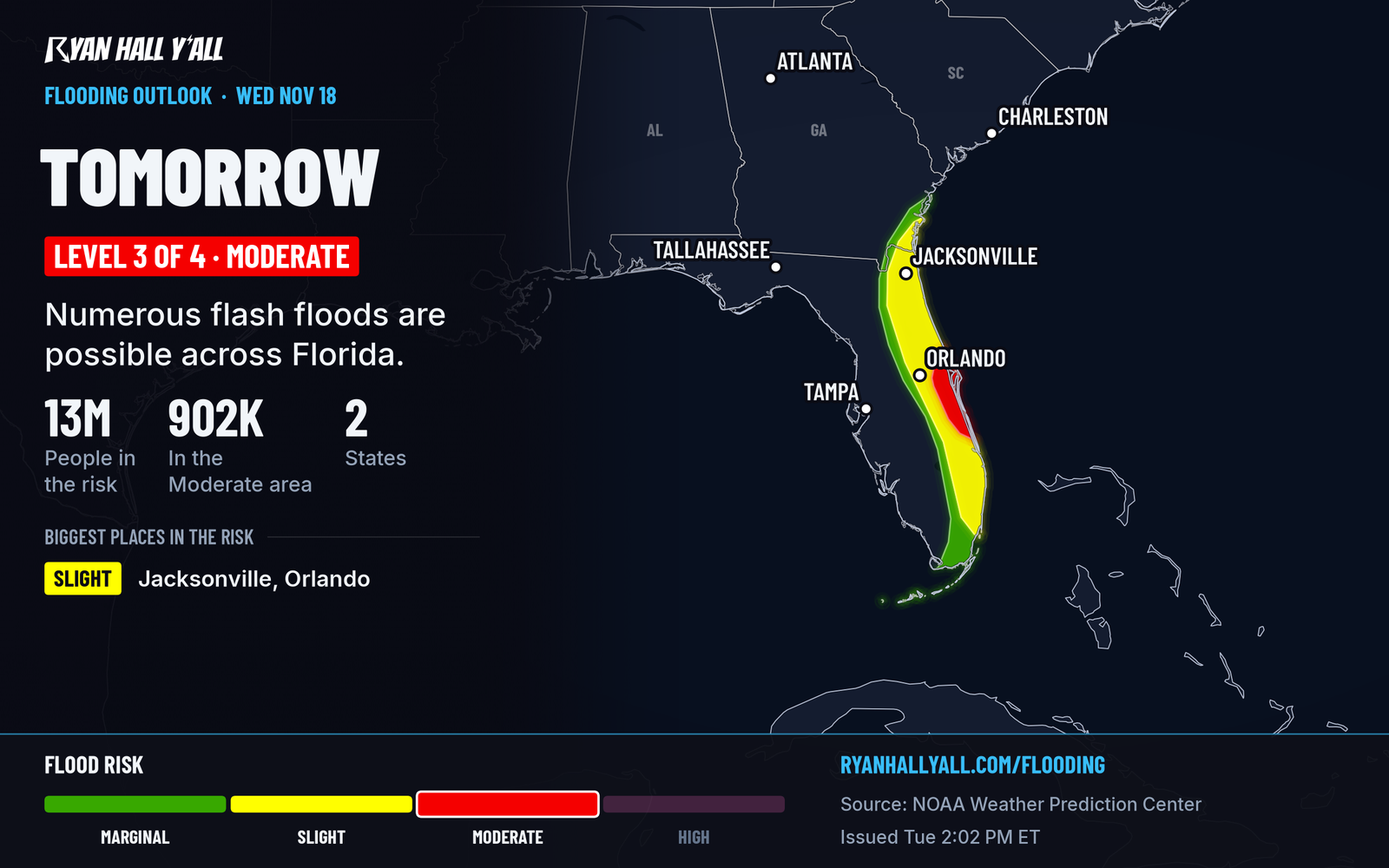
Nothing changed for Wednesday. It is still Level 3 of 4 (Moderate) from St. Lucie County north through Melbourne, Cocoa Beach and Titusville, with 3 to 5 inches widespread and 5 to 8 inches or more where the bands sit still. What is new is Thursday, Nov. 19: it now shows Level 3 on our maps too, so the soaking repeats over ground that is already full. Where the heaviest band sets up Thursday is still uncertain.
A Flood Watch for southeast Florida (Palm Beach, Broward and Miami-Dade) runs through Thursday evening. Our flash flood outlook updates through the night. The full Wednesday breakdown is in this earlier story.
Snow in Utah and Montana, minor flooding on the Texas coast
The Wasatch Mountains get 4 to 8 inches above 8,000 feet, and the Upper Cottonwoods could top 12 inches. The Wasatch Back, including Park City and the Ogden valley, gets 1 to 4 inches. Montana gets up to 4 inches with gusts to 45 mph. Both advisories run until 11 AM MST Wednesday.
On the Texas coast, a Coastal Flood Advisory for Aransas, Kleberg, Nueces, San Patricio, Refugio and Calhoun counties runs until noon CST Wednesday. Expect minor coastal flooding.
Northern lights chance, and a quiet middle of the country
Active to isolated G1 (Minor) geomagnetic storm levels are likely tonight into Wednesday. Our space weather page has the latest. Elsewhere, no severe storms are expected through Thursday. Wednesday is dry and mild from west and north-central Texas through the Southern Plains, with the best weather in west Texas and southeast Arizona.
Bottom line
California gets the big weather Wednesday, with heavy rain in the valleys and 1 to 3 feet of Sierra snow that can close the passes. Florida's east coast stays in flood mode through Thursday. Get your plans settled tonight.
More on Florida flooding, November 2026
Places in this story: Sacramento, CA
Sources
- WPC Day 2 Excessive Rainfall Outlook, NOAA Weather Prediction Center, issued
- Ryan Hall, Y'all winter storm outlook, day 2 (our own outlook), Ryan Hall, Y'all, issued
- WPC Winter Storm Severity Index (WSSI), NOAA Weather Prediction Center
https://ryanhallyall.com/news/florida-flood-risk-rises-to-level-3-thursday-sierra-snow-wednesday