Forecasts
Jacksonville flash flooding tonight; Carolina coast soaked Saturday, Nov. 21
By Ryan Hall, Y'all Weather Desk · Published
Written by our automated news desk from National Weather Service data.
What's new: The top-end Level 4 flood risk was dropped this afternoon as the heaviest rain lifted north, leaving a Level 3 of 4 from Palm Coast to Jacksonville and far southeast Georgia tonight.

Key points
- Palm Coast to Jacksonville to far southeast Georgia, tonight: Heavy bands over ground that's already soaked. Expect flooded streets and low spots. Don't drive through water over the road.
- Hilton Head to Wilmington, Saturday: Level 2 of 4 (Slight) flash flood risk, with 3 inches or more possible along the Lowcountry coast. Gusty winds, high surf and coastal flooding come with it.
- Utah's Wasatch, tonight into Saturday morning: 12 to 24 inches in the mountains, 4 to 8 in Park City and the Ogden Valley. Plan on slow, snowy canyon roads.
- Western Oklahoma to south-central Kansas, Saturday evening and overnight: Isolated storms with gusts to 60 mph and quarter-size hail. This is a Level 1 of 5 (Marginal) day.
- San Francisco Bay, Monday through Thursday, Nov. 26: A Coastal Flood Warning starts at 6 AM PST Monday, with up to 3 feet of water over low-lying shoreline.
Jacksonville flash flooding tonight, then heavy rain on the Carolina coast Saturday
The top-end Level 4 flood risk was dropped this afternoon, but a Level 3 of 4 (Moderate) threat remains tonight from Palm Coast through Jacksonville, Florida, into far southeast Georgia. The risk runs until 7 AM ET Saturday, with rain falling at 1 to 2 inches an hour or more. Saturday, Nov. 21, the heaviest rain moves north to the South Carolina Lowcountry and the coast up to Wilmington, North Carolina.
Northeast Florida: the worst rain has lifted north
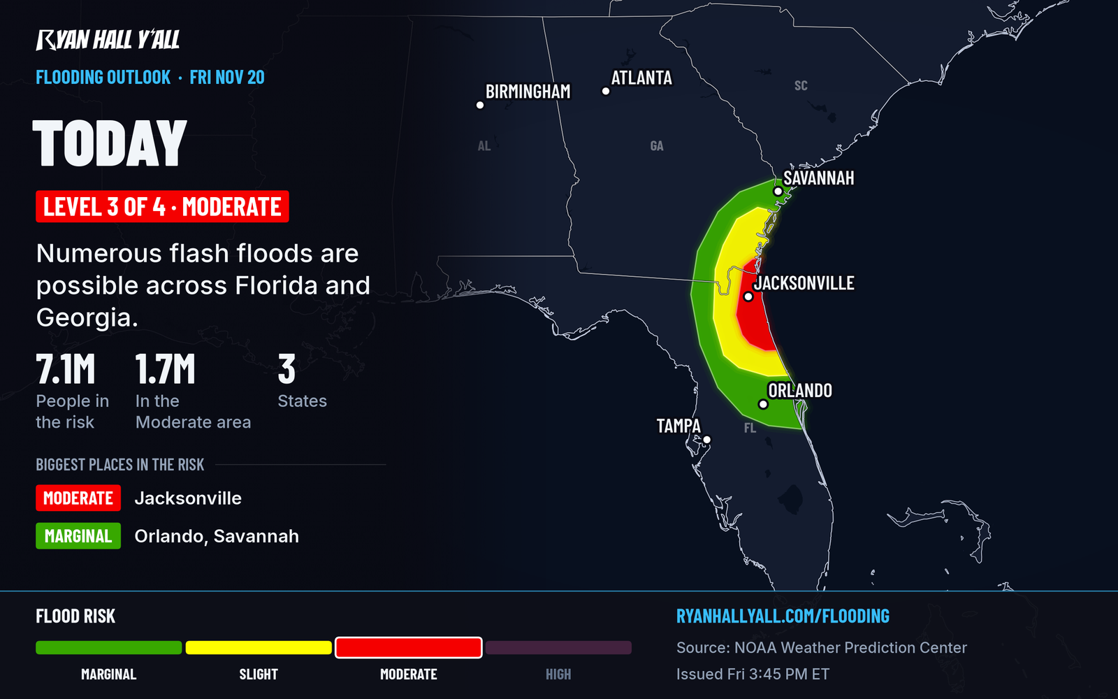
Since this morning, the top-end Level 4 risk has been dropped. Most of the heaviest rain has moved north of the Space Coast and Daytona Beach. The Moderate risk now sits from Palm Coast through the Jacksonville area into far southeast Georgia. Odds of more than 3 inches in six hours run above 70% in that zone. A Flood Advisory was up for southeastern Duval County until 6:30 PM ET.
A weak low near the coast could also spin up isolated strong storms in coastal northeast Florida tonight. That's a Level 1 of 5 risk: a small chance of damaging gusts and a brief tornado, around 2% for the tornado. Heavy rain is the bigger problem.
River flooding is the slow part of this. A Flood Warning for the St. Johns River near Sanford says minor flooding is happening and major flooding is forecast. The warning remains in effect until further notice. A Coastal Flood Warning covers Inland Flagler County until 7 AM EST Sunday, while a Coastal Flood Advisory covers Eastern Clay, South Central Duval and Western St. Johns counties until 1 PM EST Monday. Move cars out of low spots before bed, and check your morning route for water. For the river record and the earlier rain, see our St. Johns River story.
Saturday: the Carolina coast takes over
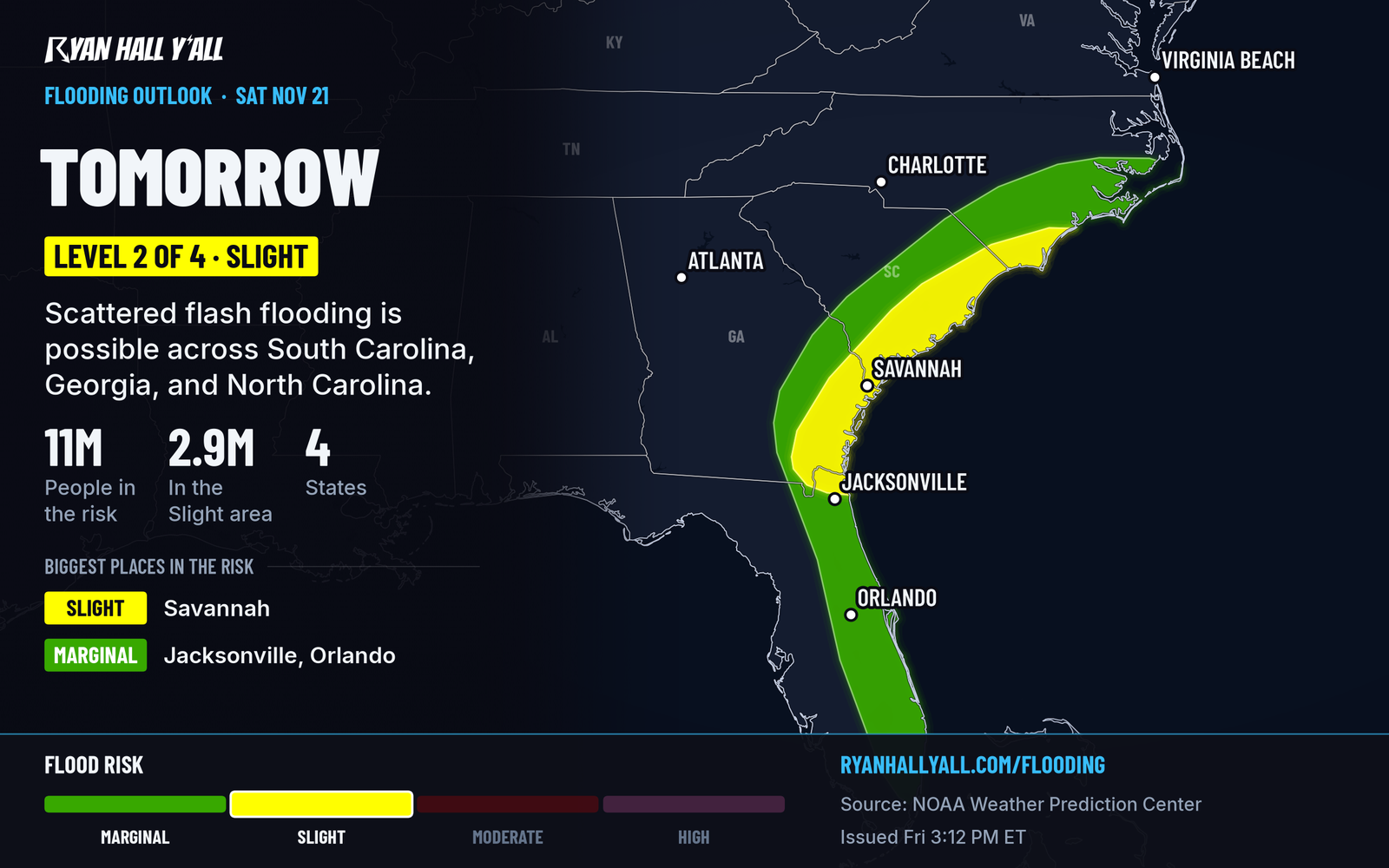
A low pulls north along the coast Saturday and Saturday night. The Lowcountry around Charleston and Hilton Head has better than 50% odds of more than 3 inches, and about 30% odds of more than 5. The risk runs up the coast to Wilmington and inland across the Georgia and South Carolina coastal plain. Dry ground should keep flooding from spreading too widely. The track is the open question. If the low shifts west, heavy bands move toward I-95 and inland flooding goes up. Our flash flood outlook has the latest, and our earlier story has the details.
The hurricane center gives a second, farther-offshore low a 30% chance of acquiring subtropical or tropical traits within two days, and 40% within seven. Named or not, the impacts are the same: gusty winds, dangerous surf, rip currents, beach erosion and coastal flooding from Georgia to the mid-Atlantic into early next week. Skip the beach Saturday.
Sunday, the low reaches the Northeast with 1 to 2 inches of rain from Hampton Roads, Virginia, to southwestern Maine. That's a Level 1 of 4 (Marginal) flood risk, held down by dry ground.
Wasatch and the northern Rockies: snow keeps falling overnight
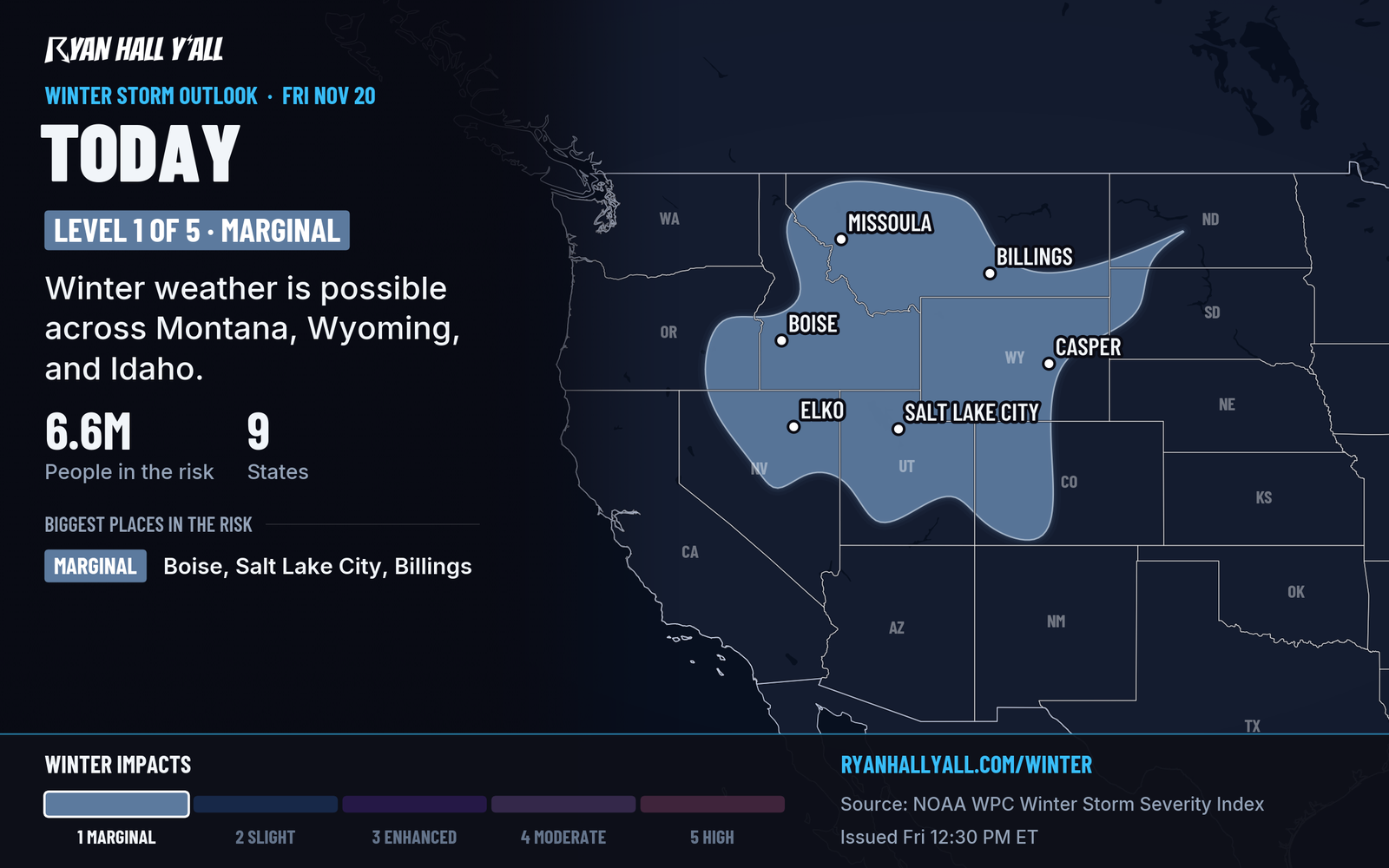
A Winter Storm Warning for the Wasatch Mountains runs until 11 AM MST Saturday, with 12 to 24 inches, the most in the Upper Cottonwoods and near the Utah and Idaho line. Advisories cover the Wasatch Back (4 to 8 inches around Park City and the Ogden Valley) and the Tetons and Snake River Plain in Idaho (up to 11 inches, gusts to 35 mph). Another 2 to 5 inches is expected in Montana's Gates of the Mountains, Cascade County below 5,000 feet, and the Northern and Southern High Plains. Snow levels fall from about 4,000 feet tonight to 2,000 feet Saturday. Some lower elevations will see their first snow of the season. Our winter outlook covers the rest of the week.
Southern Plains: isolated evening storms Saturday
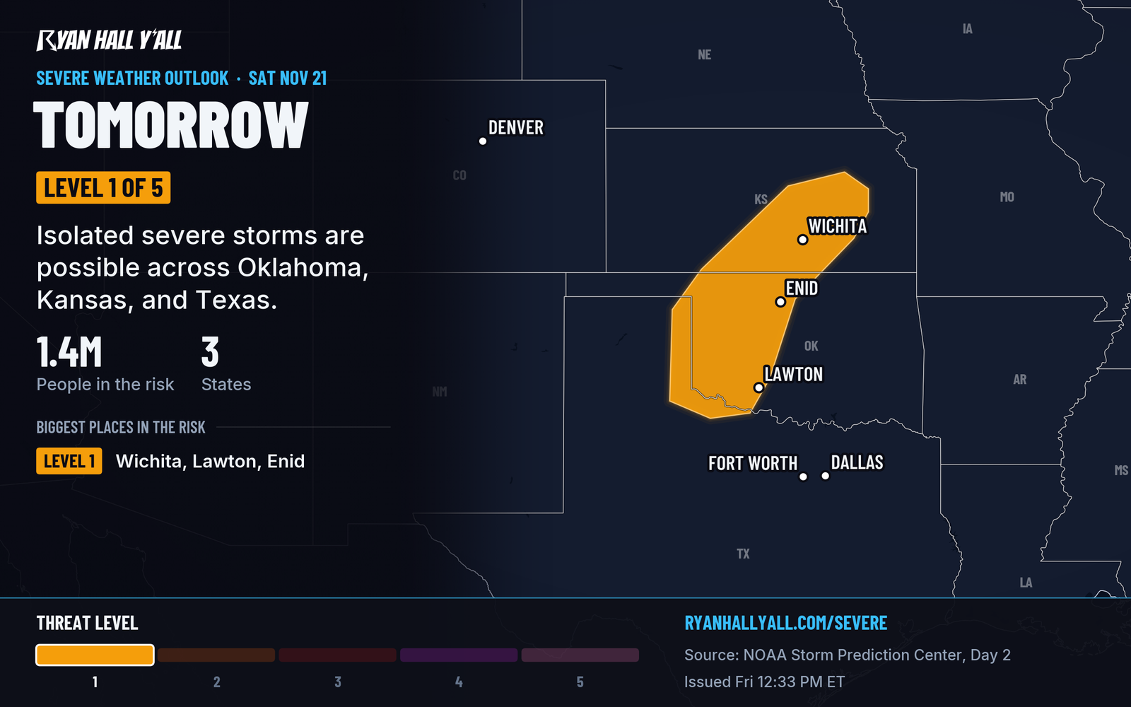
A cold front and a disturbance move through western Oklahoma, western north Texas and south-central Kansas, around Lawton, Enid and Wichita. The best storm chances come after 6 PM CST Saturday and overnight. Storm fuel is limited, but isolated gusts to 60 mph and quarter-size hail are possible. Keep an eye on the sky and have a way to get alerts, like our free Y'all Alerts. Much colder air follows the front after a spell of near-record warmth.
Bay Area: king tides meet a stormy week
The San Francisco and San Pablo Bay shorelines are under a Coastal Flood Advisory until 6 AM PST Monday. A Coastal Flood Warning then runs from Monday through 4 PM PST Thursday, Nov. 26, with up to 3 feet of water over low ground. High tides and a wet Pacific pattern next week are the reason. Avoid parking in low shoreline lots, and watch the tide tables if you're heading to the water.
Bottom line
Tonight is a flooding night from Palm Coast to Jacksonville, and Saturday is the Lowcountry's turn. The Carolina track is the uncertain part. Utah's Winter Storm Warning runs until 11 AM MST Saturday, and the Plains storms are isolated. The live warnings page is the place to check overnight.
More on Florida flooding, November 2026
Places in this story: Jacksonville, FL; San Francisco, CA; Wilmington, NC
Sources
- SPC Day 2 Convective Outlook, NOAA Storm Prediction Center, issued
- WPC Day 1 Excessive Rainfall Outlook, NOAA Weather Prediction Center, issued
- WPC Day 2 Excessive Rainfall Outlook, NOAA Weather Prediction Center, issued
- Ryan Hall, Y'all winter storm outlook, day 1 (our own outlook), Ryan Hall, Y'all, issued
- WPC Winter Storm Severity Index (WSSI), NOAA Weather Prediction Center