Forecasts
Coastal low forms near Florida; flood risk reaches Northeast coast Sunday
By Ryan Hall, Y'all Weather Desk · Published
Written by our automated news desk from National Weather Service data.
What's new: A broad low pressure area has now formed over southeastern Florida, the northwestern Bahamas and adjacent waters, with a 30% chance of tropical or subtropical development within 48 hours and 50% within 7 days, and Sunday's flood risk now re
Key points
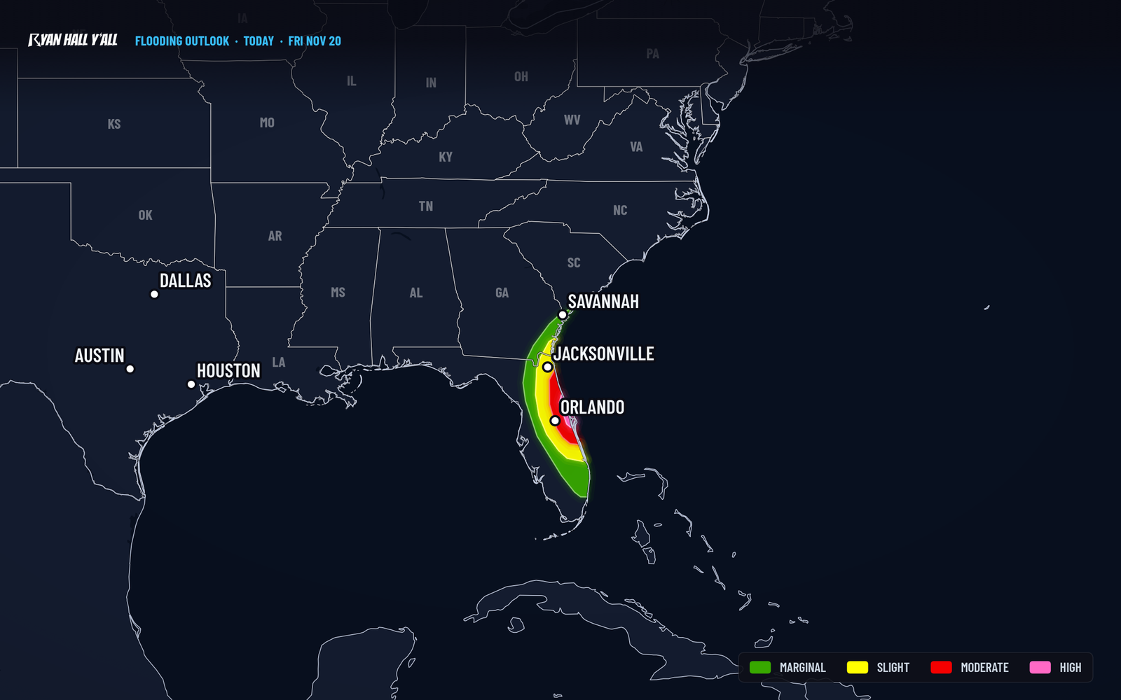
- Eastern Florida, today: Level 4 of 4 flash flood risk, with rain rates up to 2 to 3 inches per hour in the heaviest bands. Roads that flooded Thursday can flood again.
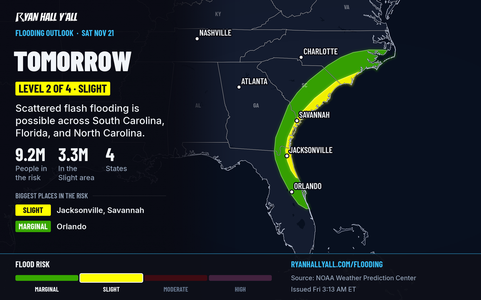
- South Carolina to North Carolina coast, Saturday: Level 2 of 4 flood risk from near Hilton Head to Wilmington, with gusty coastal winds and rough surf.
- Mid-Atlantic to New England coast, Sunday: Level 1 of 4 flood risk over Massachusetts, New Jersey and New York. How far inland the rain reaches is unsettled.
- Utah's Wasatch Range, today: Heavy mountain snow and a cold front this afternoon and evening, with sudden snow squalls possible on I-15 and I-80 near Salt Lake City.
- Kansas, Oklahoma and north Texas, Saturday: Isolated strong to severe storms are possible in a Level 1 of 5 (Marginal) risk, with severe hail or damaging wind.
A broad low pressure area has now formed over southeastern Florida, the northwestern Bahamas and adjacent waters, with a 30% chance of tropical or subtropical development within 48 hours and 50% within 7 days. It moves generally north to north-northeast near or just off the Southeast coast through the weekend, bringing heavy rain and a Level 2 of 4 flood risk near the coast from Hilton Head to Wilmington Saturday, Nov. 21, and rain with a Level 1 of 4 risk over Massachusetts, New Jersey and New York Sunday, Nov. 22; meanwhile, eastern Florida from Daytona Beach south through the Space Coast to Palm Bay remains at Level 4 of 4 today after 6 to 12 inches or more of rain.
Florida's east coast stays under a Level 4 of 4 flood risk today
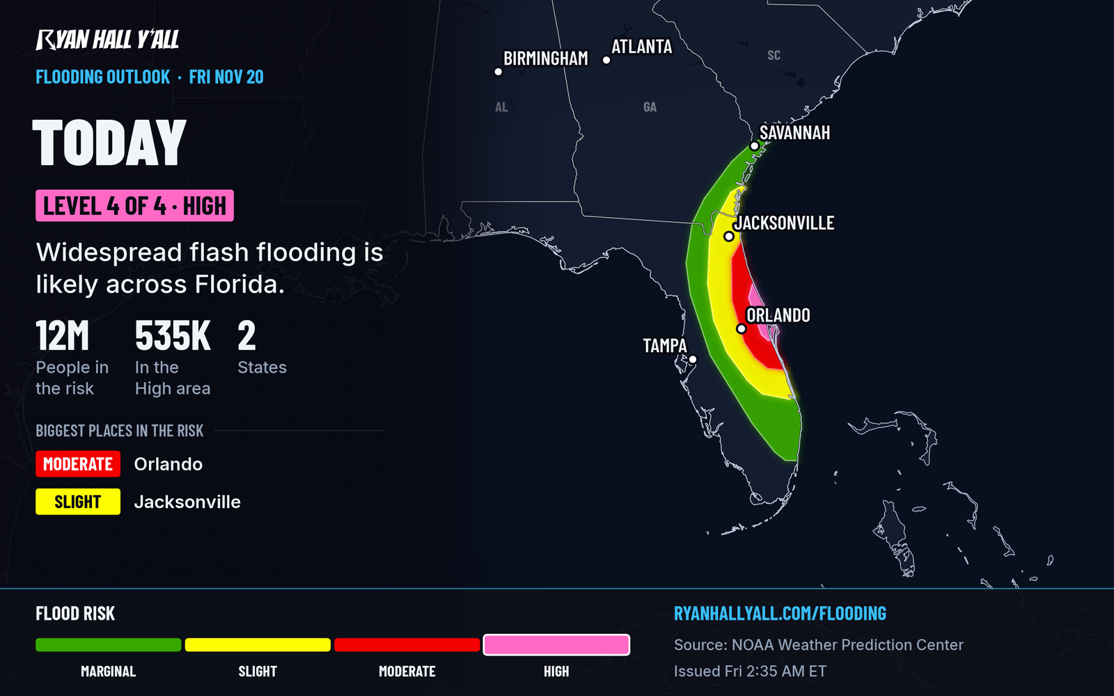
Another round of heavy rain is expected this morning across the east coast of Florida. Brevard County is the focus, with Volusia County just north of it. Easterly winds are feeding bands of rain onto the same stretch of coast, so the same neighborhoods keep getting hit. Rates of 2 to 3 inches per hour are possible in the strongest bands. With that much water on saturated ground, flooding comes fast.
The St. Johns River near Cocoa already set a record of 18.27 feet Thursday and is forecast to stay high into Monday, Nov. 23. We have the details in our St. Johns River desk story.
If you live or drive on the Space Coast, plan around the water today. Don't drive through water over the road. Check your route before you leave, because spots like SR 520 near the Beachline flooded Thursday. The heaviest rain should ease late tonight into early Saturday. The flood risk is at the highest level, and the river will not drop quickly even after the rain stops. Our flash flood outlook has the latest.
A coastal low pushes heavy rain from Georgia to the Carolinas Saturday
The low has formed over southeastern Florida, the northwestern Bahamas and the nearby waters. It moves north to north-northeast near or just off the Southeast coast through the weekend. The Hurricane Center gives it a 30% chance of becoming a subtropical or tropical storm within 48 hours and a 50% chance within 7 days. Even if it never gets a name, it can still bring heavy rain and gusty winds.
On Saturday the heaviest rain shifts north, from northeast Florida and coastal Georgia through coastal South Carolina to southeastern North Carolina. The highest risk is near the coast from around Hilton Head to Wilmington, where a Level 2 of 4 (Slight) flood risk is up. The strongest rain bands should stay near the coast or offshore. A track farther west could push heavy bands toward the I-95 corridor, and that track is not locked in. Expect gusty winds, rough surf and rip currents at the beaches, and avoid swimming. Airport delays are possible at Savannah, Charleston and Myrtle Beach.
Florida slowly improves Saturday, but rivers there stay high. Watch the tropical page for any change in the odds.
Rain reaches the Northeast coast Sunday
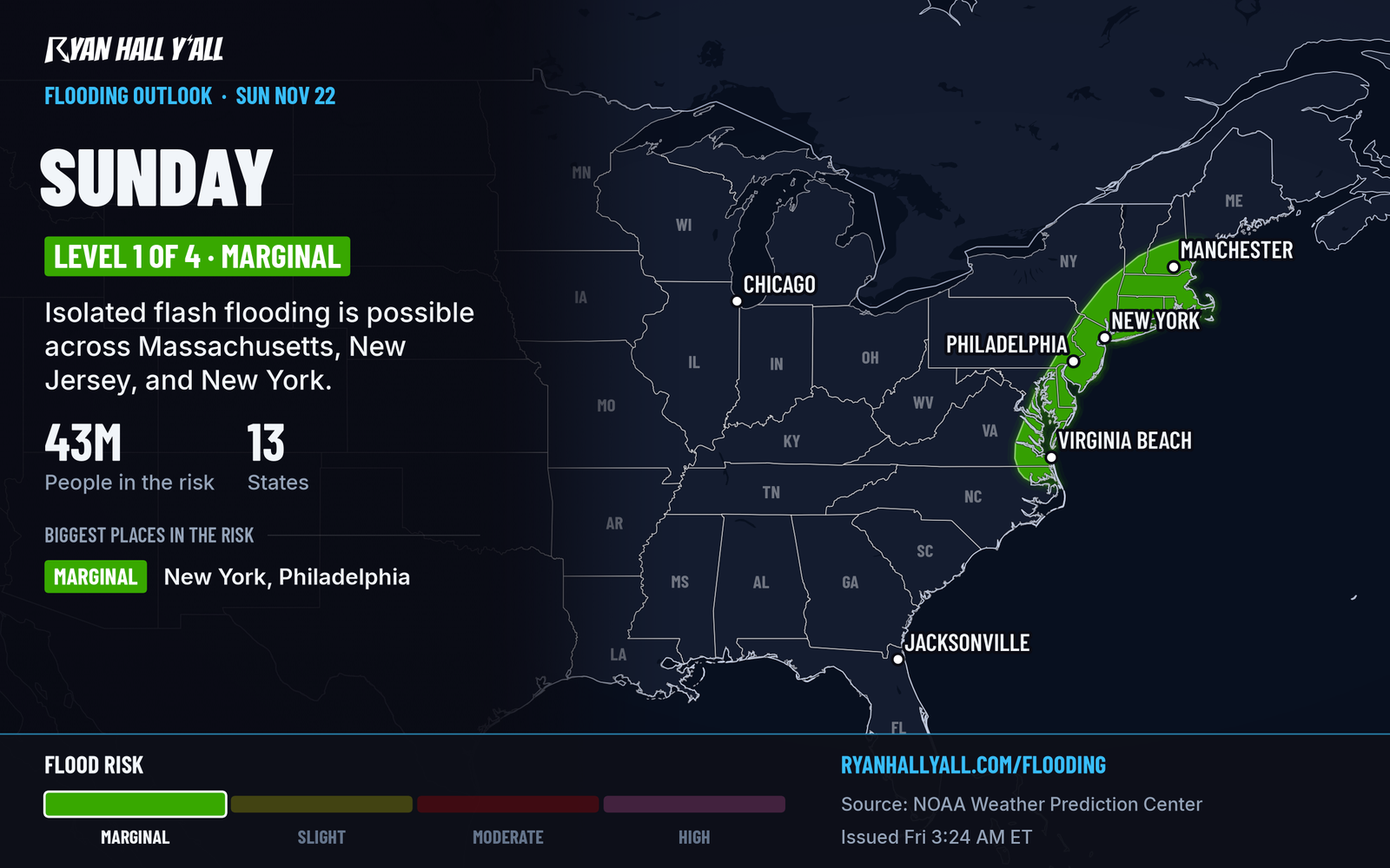
The low keeps lifting northeast Sunday. A Level 1 of 4 (Marginal) flood risk covers Massachusetts, New Jersey and New York, and the wider rain area runs from the Delmarva Peninsula to central New England. The big question is how far west the steady rain gets. Some forecast models keep it close to I-95 and the coast. Others push heavier rain inland toward I-81. If you're traveling Sunday from Washington to Boston, expect slow roads and possible delays at Northeast airports. Conditions should clear Monday.
Heavy snow continues in the Wasatch and the Rockies today
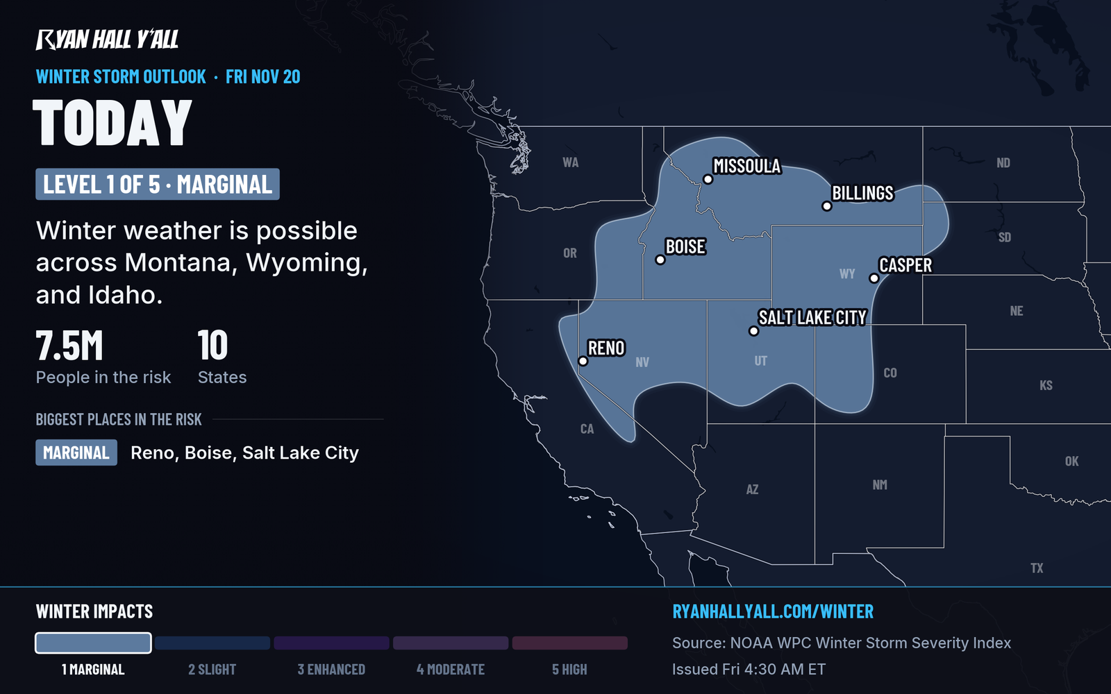
Utah's Wasatch Range is the heart of this one, with 12 to 24 inches expected in the mountains above Salt Lake City and Ogden. A cold front crosses Friday afternoon and evening and can bring sudden snow squalls and low visibility on I-15 and I-80 in the valleys. Our snow forecasts have totals by range. Mountain and Intermountain West snow keeps going in lighter form through the weekend. Saturday's interstate outlook has use-caution stretches on I-15, I-80, I-25, I-70 and I-90, mostly from cold temperatures and some snow.
Isolated storms possible in the southern Plains Saturday
A Level 1 of 5 (Marginal) risk covers parts of north Texas, western Oklahoma and central Kansas, including the Wichita, Lawton and Enid areas. Damaging wind and severe hail odds are each 5%, so any severe storms should be isolated. Keep an eye on the sky Saturday afternoon and evening. Today, strong south winds of 20 mph or more and dry air raise the fire danger on the central High Plains.
Looking ahead
The best weather Saturday is in a patchwork of Nice areas from the central Great Lakes and Ohio Valley through the Tennessee Valley. Sunday looks beautiful over southern Mississippi, Alabama, the Florida Panhandle and northwest Georgia. See our Nice Weather outlook for more. Next week, mountain snow returns to the Cascades and northern Rockies, and a coastal system could bring unsettled weather to the East heading into Thanksgiving. It is too early for details on that one.
Bottom line
If you're on Florida's Space Coast today, stay off flooded roads and plan around the rain. Then watch the coast from Georgia to New England this weekend, because the track of the low decides who gets the heaviest rain.
More on Florida flooding, November 2026
Places in this story: Salt Lake City, UT
Sources
- WPC Day 1 Excessive Rainfall Outlook, NOAA Weather Prediction Center, issued
- WPC Day 2 Excessive Rainfall Outlook, NOAA Weather Prediction Center, issued
- WPC Day 3 Excessive Rainfall Outlook, NOAA Weather Prediction Center, issued
- Ryan Hall, Y'all winter storm outlook, day 1 (our own outlook), Ryan Hall, Y'all, issued
- WPC Winter Storm Severity Index (WSSI), NOAA Weather Prediction Center