Weather news
October 2026 was Earth's warmest October, third month in a row above 1.5 C
By Ryan Hall, Y'all Weather Desk · Published · Updated
Written by our automated news desk from National Weather Service data.
What's new: Leads with the third straight month above 1.5 C and Europe's second-warmest October; South Texas flash flood risk and storm details refreshed
Europe's Copernicus climate service says October 2026 was the warmest October on record worldwide. It was 1.75 C above the pre-industrial average, the third straight month above 1.5 C, and Europe had its second-warmest October. The global number does not change your forecast, which today includes a Level 2 of 4 flash flood risk in South Texas.
Key points
- Where: The whole planet. This is a global average, not a U.S. number.
- When: October 2026, with the data published this week.
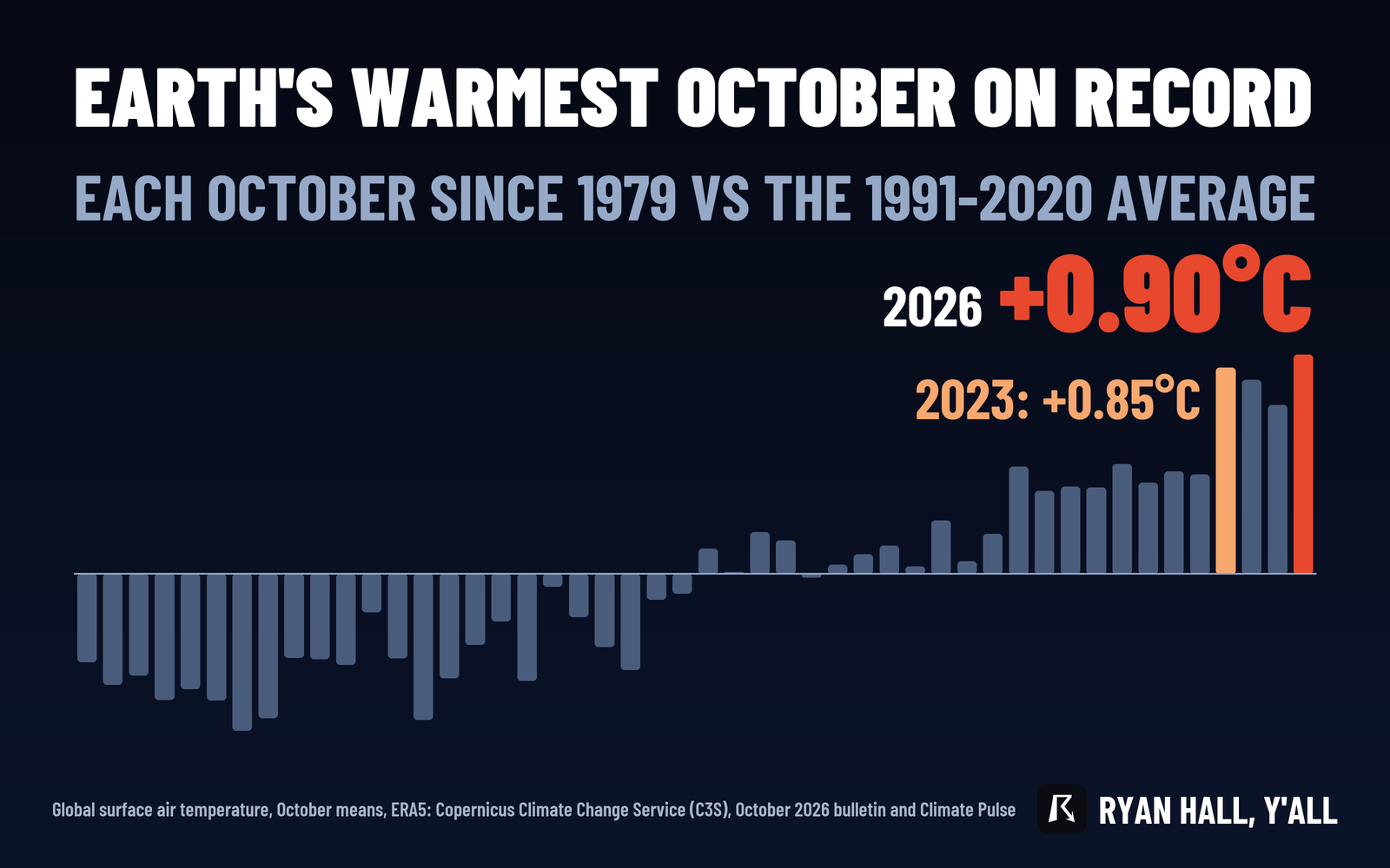
- What: The global surface air temperature averaged 15.35 C, which is 0.90 C above the 1991-2020 October average. That beats the old record from 2023, at 0.85 C above average.
- The 1.5 C mark: October ran 1.75 C above the 1850-1900 average, the third straight month above 1.5 C. Europe was second-warmest for the month.
- What it means for you: It's a climate measurement, not a forecast. Today's weather story is a Level 2 of 4 flash flood risk in South Texas.
Updated 12:45 PM ET Sunday.
The planet just had its warmest October on record, and it was the third month in a row more than 1.5 degrees Celsius above pre-industrial levels. Europe's Copernicus Climate Change Service also reports that Europe had its second-warmest October. NOAA's own global report is due around Thursday, Nov. 12, and we'll check how it ranks the month.
A record by a narrow margin
The margin over 2023 is small, just 0.05 C, but the old October mark has been beaten. Copernicus measures against the 1991-2020 average, so this is the figure to compare with earlier Octobers.
Land alone did not set a record. Land temperatures averaged 10.82 C, joint third highest for October. That matches October 2025 and trails only October 2023 and 2024. The global number includes the oceans, so the record came from the planet as a whole.
Third month in a row above 1.5 C
The 1.75 C figure compares October to the estimated average for the same month in 1850-1900, the pre-industrial baseline Copernicus uses. In Fahrenheit, that's about 3 degrees warmer than the late 1800s. October followed two other months above the 1.5 C line, so this is a run, not a one-month blip. One month over 1.5 C is not the same as the long-term warming level that international climate targets refer to, which is measured over many years.
Europe's second-warmest October
Copernicus ranks Europe's October as the second-warmest on record for the month. We don't have a temperature figure for the continent, so we'll leave it at the ranking.
What it means for your weather this week
A global record doesn't change the forecast where you live. Here is what's on the map.
South Texas is the main weather story. A Level 2 of 4 (Slight) flash flood risk covers South Texas through early Monday, now trimmed closer to the coast. Parts of the area have already soaked up more than 2 inches of rain, and some spots from east of Laredo to near Kingsville have picked up over 5 inches. Another round of storms is expected this evening and overnight on that wet ground, so flooding is a real concern. Flash Flood Warnings are in effect right now. Our flash flood outlook has the latest.
Monday brings a Level 1 of 4 (Marginal) risk. Rain should taper off south and southeast of I-10, with the best chance of trouble inland west and northwest of Corpus Christi down to the far South Texas coastal plain. Most places should see another half inch to an inch, though a few spots could get 2 to 4 inches. That is the less likely outcome.
Severe storms are a Level 1 of 5 (Marginal) risk along the Texas coast from near Kingsville to Port Mansfield. A brief, weak tornado or a damaging wind gust is possible today, but the odds are low.
Later this week, a coastal storm is forecast to form off the Mid-Atlantic coast Thursday into Friday. Most of the coast will see rain, but colder air wrapping in could change rain to accumulating snow on higher terrain in northern Pennsylvania, upstate New York and interior northern New England. Albany and Binghamton are in the area to watch. Confidence is moderate overall, and the exact track and the rain-snow line are still uncertain. See our winter storm outlook for updates.
What to do
- In South Texas, don't drive into water over the road this afternoon, tonight or early Monday. Ground that's already soaked can flood fast when the next round arrives. Check active warnings before you head out.
- If you plan to travel through the Northeast hills Thursday into Friday, watch for slick roads and check the forecast again midweek.
- Check back around Nov. 12 for NOAA's ranking of October.
Bottom line
October 2026 was the warmest October on record worldwide, the third month in a row above 1.5 C over pre-industrial levels, and Europe had its second-warmest. For your plans this week, keep your eyes on South Texas tonight.
Explained: What the flash flood risk levels mean, from Level 1 to Level 4
More on Weather records, October 2026
Sources
- Copernicus Climate Change Service (C3S), Surface air temperature for October 2026 (ERA5), Copernicus Climate Change Service (ECMWF)
https://ryanhallyall.com/news/october-2026-was-earths-warmest-october-on-record-copernicus-says